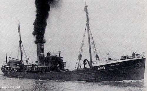
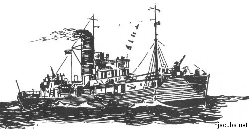
HMS Pentland Firth
- Type:
- shipwreck, trawler, Royal Navy
- Name:
- Pentland Firth is the channel between the northern tip of Scotland and the Islands that form Scapa Flow, the great British naval base, and today one of the best wreck diving locales in the world.
- Built:
- 1934, England
- Specs:
- ( 164 x 27 ft ) 485 gross tons
- Sunk:
- Saturday September 19, 1942
collision with minesweeper trawler USS Chaffinch (400 tons) - ? casualties - GPS:
- 40°25.433' -73°52.204' (AWOIS 1991)
- Depth:
- 70 ft
The Pentland Firth was an "antisubmarine trawler", on loan to US Navy.
The wreckage of the Pentland Firth is spread over a wide area just west of the shipping lane. Hull plates and twisted metal are the most notable features. She rises 10 ft or so off the bottom at best. Visibility is usually poor since she sits in an area once used as a dumping ground. Sometimes wrongly known as "Pentland First".
from AWOIS: 1595
H10224/86 -- OPR-C121-WH-86; WRECK WAS FOUND WITH A PNEUMATIC DEPTH GAUGE LEAST DEPTH OF 52 FT; WRECK WAS OF A METAL HULLED VESSEL APPROXIMATELY 110 FT LONG AND LAYING ON A PORT LIST INTO A SAND AND GRAVEL BOTTOM; IN APPROXIMATELY THE CENTER OF THE WRECK DIVERS FOUND A LARGE METALLIC CYLINDER LYING ON ITS SIDE WITH A SMALLER ONE EXTENDING UPWARDS FROM IT; LARGE AMOUNTS OF BENT AND TWISTED DECK PLATING, PIPING AND METAL BEAMS FOUND. (UPDATED MSD 4/91)
Questions or Inquiries?
Just want to say Hello? Sign the .