Dive Sites
Dive Sites - pick your starting point
Here is a comprehensive listing of dive sites in the New Jersey / Long Island area, covering shipwrecks, artificial reefs, beach dives, and selected inland sites. The emphasis is on recreational ( less than 130 ft ) diving in northern New Jersey, since that's where I live and dive. The current total is over 400 references, although this includes a few shipwrecks that are of purely historical interest.
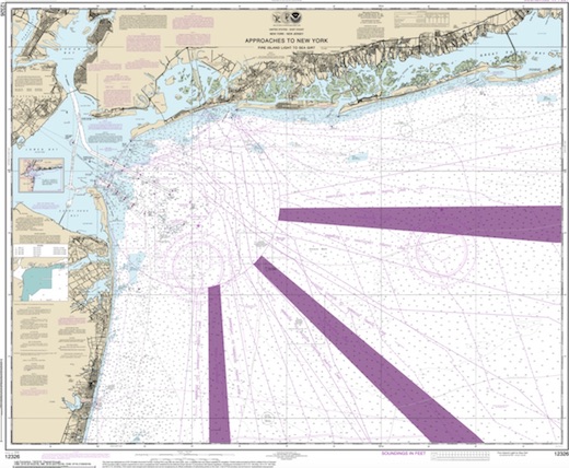
New Jersey is a superb place for wreck diving. Estimates of the number of wrecks off this coast are between 4000 and 7000. To get some idea of what a staggering figure this is, take a look at the charts here, and for every black cross denoting a shipwreck, imagine 15-20 more. As if this was not enough, every year many excellent new "shipwrecks" are added by active artificial reef programs in both New Jersey and New York. Wrecks vary in age from the 18th century to World Wars I & II to the present day.
- Home ...
- Dive Sites ...
- Artificial Reefs ...
- Marine Biology ...
- Artifacts ...
- Gear & Training ...
- Blog ...
- Cozumel ...
A Note on the "Numbers" Here
Anyone can look at the html source of this page and see the numbers that I have kept hidden for many years. Understand though, these numbers are not GPS and are not good enough for navigation, although they may appear to be. Most of them are the old Loran conversions I started with many years ago, which are still perfectly good for putting a spot on a digital map. Any accurate numbers that were given to me in confidence have been fudged.
About the Charts
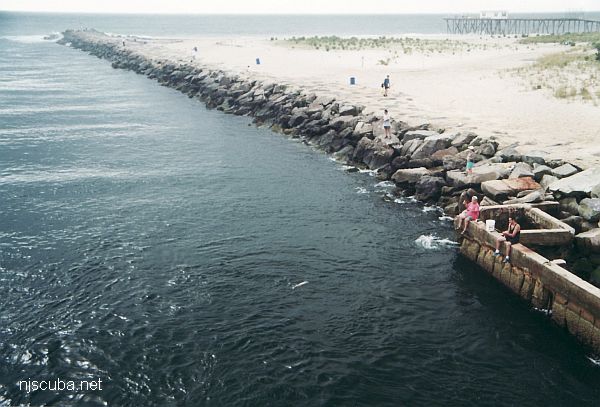
The thin red line is the state jurisdiction, nominally 3 nautical miles from shore. This is important for fishing and lobstering, as regulations vary from state to state. Outside the 3-mile limit Federal regulations apply. The thin blue line is 12 nautical miles from shore, which was once the Federal limit, now 200 miles. The pink bars are the shipping lanes.
You can navigate this site by clicking on the colored chart labels to bring up information or more detailed charts ( there are ten interlinked main charts, and a number of smaller detail charts ) Alternatively, you can use the table of contents and scroll through the pages manually. The text table of contents also contains a number of interesting web links for this section.
GPS Numbers
Many people ask for Loran GPS numbers for the sites described in these pages. My policy is to not list numbers, as many of them were given to me in confidence, and I will not accidentally release someone's secret. However, after I added all the highly accurate and public-domain GPS numbers in the Artificial Reefs section of the website, I have reconsidered that position, somewhat.
What I have done is collect "GPS numbers" from four public lists, and compile them into a single spreadsheet. I culled the obvious errors, cleaned up the names, and sorted all the data. The numbers are in both common formats: degrees-minutes and degrees-decimal. You can download it here.
You'll notice that there are multiple entries for many wrecks, each listing the source. Often, these numbers turn out to be a quarter-mile apart or more. If two numbers agree, that is more likely an indication that one was copied from the other than that they are right. Some of these numbers might be accurate, but I couldn't tell you which, or which source is the best.
The GPS in my phone helps me find my way out of the woods when I get lost with the dog. The GPS in your car will show you which lane of the highway you are in. These 'GPS Numbers' often can't agree within a quarter of a mile of each other. What this shows is just how awful these public GPS lists really are - they are little more than bad Loran conversions from twenty years ago. If you don't believe me, plug a few of the numbers into the calculator and see for yourself.
Here is one incredible example: two sets of numbers given for the Delaware are over 2 miles apart !!! The Delaware is only 3 miles off the beach, and you can find it by land ranges with no instruments at all:
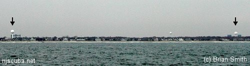
Note the locations of the two sets of water and bridge towers.
This is indicative of the quality of the entire list - it is garbage. This particular error is probably a typo, but that's what happens when the same junk gets handed down for 20 years.
On the scale of my graphical charts, most of the errors might move a marker one pixel - so for my purposes it doesn't matter. But if you want to actually go out and find a wreck with these numbers, pack a lunch - you're going to be 'mowing the lawn' for a while! That is not to say there are not accurate sources for GPS numbers, but you will have to pay for them. See References.
I have added a few GPS numbers from government sources where the accuracy is high. I'm not going to all the trouble and public disservice of posting all the trash numbers.
I found this online Loran conversion tool from NOAA.
Cape May Artificial Reef
8.5 Nautical Miles off Cape May, 5.34 sq miles
Depth: 50-75 ft [download]
More: Cape May Artificial Reef ...
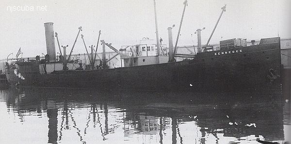
- Type:
- shipwreck, freighter, USA
- Name:
- Kennebec is a county and a major river in the state of Maine.
- Built:
- 1901, Jenks Shipbuilding, Port Huron MI USA
- Specs:
- ( 243 x 43 ft ) 2183 gross tons, 29 crew
- Sunk:
- Saturday June 18, 1921
sprung a leak - no casualties
More: Kennebec ...
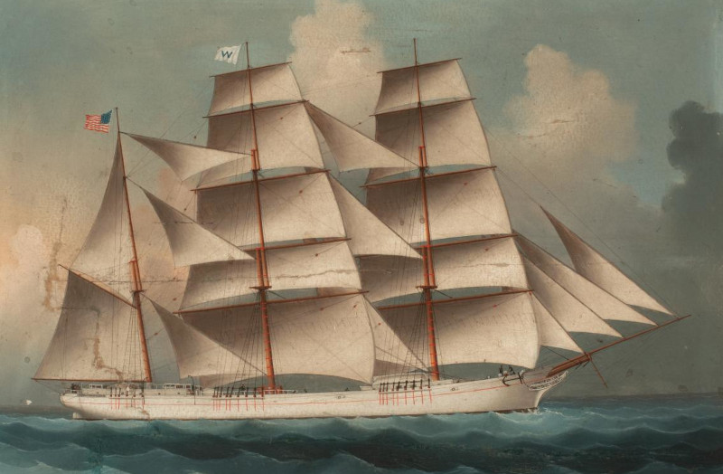
- Type:
- shipwreck, sailing ship
- Built:
- Russell Ship Building Company, East Deering ME, 1873
- Sunk:
- Saturday December 14, 1907
ran aground 72 mph gale - no casualties (incredible) - Depth:
- 25 ft
More: Edmund Phinney ...
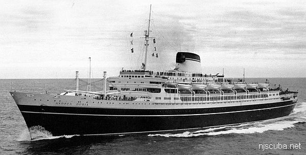

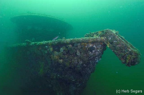
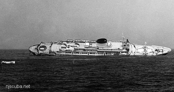
- Type:
- shipwreck, liner, Italy
- Name:
- A 16th century Genoese Admiral. This name had been previously carried by a number of Italian warships ( see page bottom )
- Built:
- 1951, Italy
- Specs:
- ( 700 x 90 ft ) 29083 displacement tons, 1706 passengers & crew
- Sunk:
- Thursday July 26, 1956
collision with freighter Stockholm ( 12000 tons) - 46 casualties - GPS:
- 40°29.405' -69°52.028' (AWOIS)
- Depth:
- 240 ft ( 190 ft minimum )
More: Andrea Doria ...
- Type:
- shipwreck, tugboat, USA
- Built:
- 1937, Bethlehem Beaumont, Beaumont TX USA
- Specs:
- ( 68 ft ) 4 crew
- Sunk:
- Tuesday November 25, 1971
structural failure during storm due to improper modifications - 2 casualties - Depth:
- 136 ft
More: Barataria ...
- Type:
- shipwreck, freighter, USA
- Name:
- Named for a town in eastern Wisconsin?
- Built:
- 1907, England, as Hogland
- Specs:
- ( 271 x 39 ft ) 1869 gross tons
- Sunk:
- Sunday June 2, 1918
bombed by U-151 - no casualties - Depth:
- 220 ft
More: Winneconne ...
Deep Sea Chart (pan right for more)
- Four Daughters
- USS Akron
- Andrea Doria
- Atlantic Princess
- Azua
- USS Baldwin
- Bidevind
- Brian C
- Carolina
- Catamount
- Cayru
- Champion
- USS Cherokee
- Coimbra
- Corvallis
- Deepwater Dump
- Durley Chine
- Edward H Cole
- Galimore's Cayru
- Lady Gertrude
- Herbert Parker
- Thomas Hebert
- Hvoslef
- Isabel B Wiley
- India Arrow
- USS Jacob Jones
- Jacob M Haskell
- Lady Mary
- Lillian
- Maiden Creek
- Miraflores
- Misty Blue
- Montgomery
- USS Moonstone
- USS Murphy
- Northern Pacific
- Norness
- Pan Pennsylvania
- Republic
- Rio Tercero
- RP Resor
- Southern Lillian
- USS S-5
- USS Salmon
- SC-209
- Sebastian
- Shookus
- Sommerstad
- USS Spikefish
- Suffolk
- Texas Tower
- Texel
- U-550
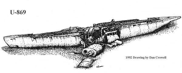
- U-869
- Varanger
- West Wreck
- Wily Fox
- Winneconne
More: Deep Sea Dive Sites ...
- Type:
- shipwreck, liner, Italy
- Name:
- A 16th century Genoese Admiral. This name had been previously carried by a number of Italian warships ( see page bottom )
- Built:
- 1951, Italy
- Specs:
- ( 700 x 90 ft ) 29083 displacement tons, 1706 passengers & crew
- Sunk:
- Thursday July 26, 1956
collision with freighter Stockholm ( 12000 tons) - 46 casualties - GPS:
- 40°29.405' -69°52.028' (AWOIS)
- Depth:
- 240 ft ( 190 ft minimum )
More: Andrea Doria ...
Marine distance measurements are expressed in terms of nautical miles. A nautical mile is significantly different from a common or statute mile. The conversion is 1 nautical mile = 1.151 statute miles, or approximately 6076 ft ( vs. 5280 ft for a statute mile. )
Why such a confounded thing as this? Here's why:
More: Distance & Navigation ...