Distance & Navigation
Marine distance measurements are expressed in terms of nautical miles. A nautical mile is significantly different from a common or statute mile. The conversion is 1 nautical mile = 1.151 statute miles, or approximately 6076 ft ( vs. 5280 ft for a statute mile. )
Why such a confounded thing as this? Here's why:
A nautical mile is actually one minute of latitude ( 1/60 degree of north-south measurement ) and is therefore much easier to use for navigational purposes. In this regard, it also makes much more sense than the rather arbitrary metric kilometer. Note that the length of a degree of latitude is invariant with location, unlike the length of a degree of longitude (east-west), which is longest at the equator and zero at the poles!
Three nautical miles make a league ( as in 20,000 Leagues Under the Sea, ) although this is not the only accepted definition. For many years, one league from the shore was considered to be the extent of a nation's maritime domain, based for practical purposes on the range of the artillery of the time. There was no point in claiming something you couldn't defend! Over time, this grew to 12, 50, and finally 200 miles, as nations sought to protect their maritime resources.
The scales on all the charts in this website are in nautical miles since this is the measure that is quoted in most references.
Latitude & Longitude
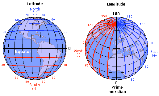
Laying out a coordinate system on a sphere is a little complicated, but it is absolutely essential for navigation out of sight of land. Earth coordinates are known as latitude and longitude. Latitude measures north-south location. It is zero at the equator, +90 at the North Pole, and -90 at the South Pole. Often, the sign is omitted or assumed and indicated by N or S. Thus 23°S is actually -23° while -23°S is redundant ( but understood not to be 23°N ! ) Degrees of latitude are constant distance, as explained above. Just remember the Jimmy Buffet song "Changes in Latitudes, Changes in Attitudes" - he's not singing about going east-west, but north-south to get away from the cold. And it's a clever rhyme.
Longitude is messier. Longitude begins at 0 at the Prime Meridian, which runs north-south through Greenwich England, the home of the British Admiralty, because they may not have thought of the idea, but they are the ones who standardized it. Longitudes run east from the Prime Meridian to +180 degrees, and west to -180 degrees, but as with latitude, the sign is often implicit and not stated. Note that +180 and -180 are the same place. Degrees of longitude are not constant distances. A degree of longitude is greatest at the equator, approximately 60.1 nautical miles, and shrinks away to zero at the poles. As with latitude, the sign is often omitted or implied.
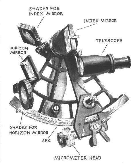
For a navigator, latitude can be determined fairly easily by sighting the angle of a known star above the horizon using a sextant. Longitude is more difficult to determine, as it requires a known star and the date and time. Nowadays we take accurate time measurement for granted, but it was not always so, and it took decades of development to come up with a clock mechanism that was not thrown off by the constant motion of a ship at sea. Again, it was the British Admiralty that was responsible. That's why they get to own the Prime Meridian.
Both latitude and longitude are expressed in degrees, minutes, and seconds. These units are similar to time units in that they are base-60, going back to the ancient Babylonian system. Thus 60 seconds = 1 minute, 60 minutes = 1 degree. Degrees-minutes-seconds are written out much the same way as time, thus:
DDD:MM:SS.SS
where seconds may have decimal places for greater accuracy
A colon is the standard separator, but you may also see a dash, a space, or some other character.
Seconds are seldom used, and coordinates are much more commonly expressed in minutes-decimal, thus:
DDD:MM.MMMM
where minutes has decimal places to the accuracy desired
DDDMM.MMMM
this form is often confusingly written without a separator
Mathematically, it is often easier to work with degrees-decimal:
DDD.DDDDDD
Note: decimal places shown give approximately +/- 1 yard precision.
Conversions are accomplished by multiplying or dividing by 60 as appropriate. The Babylonians had 10 fingers and 10 toes just like everyone else, but they found 60 to be very convenient, because it is divisible by 2, 3, 4, 5, 6, 10, 12, 15, 20, and 30. 10 is divisible by only 2 and 5, and fractional goats had a short shelf life before refrigeration.
Time zones are related to longitude. 360 degrees / 24 hours = 15° / hour. So each time zone should be 15 degrees wide, and one 360 degree rotation of the earth equals one 24 hour day. However, this is often adjusted for practical reasons, for example not wanting to split a state across two time zones. Sometimes it is messed-with for political reasons - those wacky North Koreans made up their own time zone just for themselves. So far they haven't made up their own Prime Meridian, yet, but if they do, no one will be able to find them !
There are two special lines of latitude: the Tropic of Cancer in the northern hemisphere, and the Tropic of Capricorn in the southern hemisphere. These are both at 23.4 degrees, which also happens to be the tilt of the earth's axis. The significance is that these are the northern-most and southernmost latitudes at which the sun can appear directly overhead. North or south of the 'Tropics', the sun can never reach a position directly overhead, but will always stay in the southern ( or northern, depending ) sky. This is the sort of thing ancient peoples were very aware of. The Tropic of Cancer passes between the tip of Florida and Cuba.
Compute distance and true course between two points
Coordinates may be entered in the following formats:
- DD.DDDD - degrees.decimal
- DD:MM.MM - degrees:minutes.decimal
- DD:MM:SS.SS - degrees:minutes:seconds.decimal
The sign (+/-) of the inputs is ignored, specify N/S/E/W instead.
The Model allows for the fact that the earth is not a perfect sphere, but is flattened at the poles and bulged at the equator by centrifical force.
Compute end coordinates given direction and distance from a starting point
Coordinates may be entered in the following formats:
- DD.DDDDDD - degrees.decimal
- DD:MM.MMMM - degrees:minutes.decimal
- DD:MM:SS.SS - degrees:minutes:seconds.decimal
The sign (+/-) of the inputs is ignored, specify N/S/E/W instead.
Note that if either point is very close to a pole, the course may be inaccurate, because of its extreme sensitivity to position and rounding error.
Calculators adapted from Great Circle Calculator by Ed Williams
with corrections & additions by ARG
Try plugging in some numbers from my "GPS" list and see just how poorly these published numbers agree with each other.
Direction
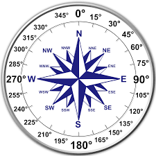
Directions are expressed as degrees around the compass from 0° to 360°. Due north = 0° or 360°, but 360° is never used. Due east = 90°, etc. Note that these are angles from due north, increasing clockwise around the compass. Latitude and longitude are also degrees of direction, measured from the center of the earth with respect to the equator and Prime Meridian. Note that unlike latitude and longitude, there are no negative directions.
In navigation, a direction is either a heading, a course or a bearing. A course is a direction of travel. It could be yourself, or something else. A heading is the direction you are pointed in, not necessarily the same as your course, owing to crosswinds, currents, etc. A bearing, or range, is a direction to an object, such as a landmark or another ship. For a ship, there is typically little difference between course and heading, but for an airplane it is significant. A major part of flight planning is calculating your heading so that your course takes you to your destination and not downwind of it.
When landing an airplane in a crosswind, one technique is to adjust your heading so your course matches the heading of the runway. For large low-wing aircraft, this is the only option and is known as 'crabbing' into the wind. There are lots of videos of wild cross-wind landings on the YouTubes, where you can clearly see the plane is not going in the same direction that the nose is pointed.
Little of this applies to driving a car, where you simply follow a path down a road, and crosswinds hardly matter. There's a joke in aviation, that IFR ( Instrument Flight Rules ) actually stands for "I Follow Roads". That is certainly something you can do over land; interstates and railroads are especially useful, so are rivers and coastlines. But it doesn't work at sea.
If you think having three different names for direction is confusing, it gets worse.
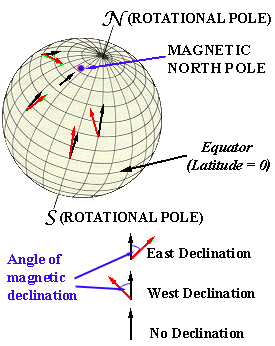
There are actually not one but two different "Norths". True north is the direction to the geographic North Pole, the point where the axis of the earth's rotation pierces the surface, where all the lines of longitude come together. That's interesting, but not terribly useful, as a magnetic compass does not point to true north, it points to magnetic north - the north pole of the earth's magnetic field. The magnetic north pole is about 300 miles from the geographic north pole, but it doesn't stay put. The magnetic pole is currently moving about 35 miles a year towards Russia. ( When it gets there, they probably won't let the rest of us use it. ) The magnetic pole also wobbles over the course of a day in response to solar wind and other factors.
But that doesn't matter, because what I said about a compass pointing to the magnetic pole isn't entirely true. At most points on the earth, a compass will point consistently in some direction, but almost never directly at the magnetic pole. That is because the earth's magnetic field is not uniform. It turns out, the precise location of the magnetic pole doesn't matter. In fact, it wasn't even found until the mid-twentieth century. However, the error between true north and where a compass points can be mapped out over the entire globe. That is the important thing.
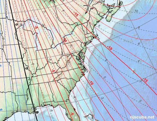
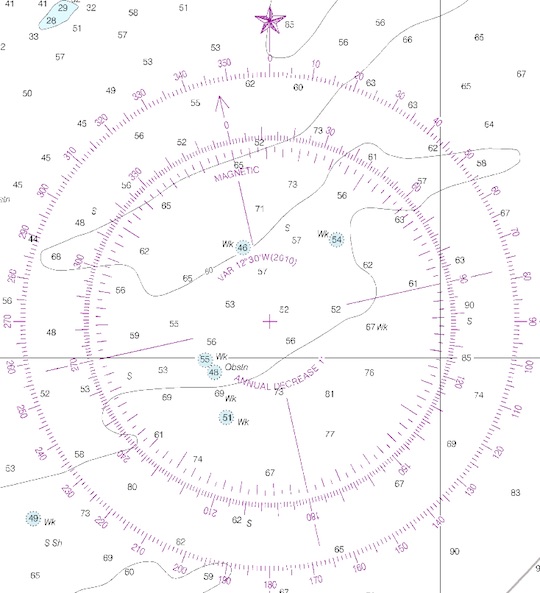
Knowing this error, known as the magnetic declination, or more commonly magnetic variation, you can subtract it from your compass reading to get true north. All navigational charts list this angle; here in New Jersey, it is about +13 degrees, or '13 west', as your compass is pointing west of true north. So subtract 13 degrees from what your compass reads to get true north. Magnetic variations can also be negative, or east. By coincidence, at present, the zero-line runs approximately down the Mississippi River. Like the magnetic pole itself, the magnetic variation changes over time, which is why it is important to use up-to-date charts.
Why is the earth's magnetic field so weird? Although it seems solid, the earth is actually a big blob of spinning goop with a thin crust and a solid core. The magnetic field is generated by convective currents of molten iron flowing in the outer core, what is known as a geodynamo. These currents are caused by coriolis force, the same thing that gives us much of our weather. The resulting magnetic field is not uniform like that of a bar magnet but varies over time and location as the flows change. Earth's magnetic field shields it from deadly solar radiation and allows a gaseous atmosphere and life on the surface. If the molten core ( which is heated by radioactivity ) should cool, the flows would cease, and the magnetic field would dissipate. The atmosphere would blow away into space, and the planet would die, much like Mars. So don't complain about it. Don't worry, though, it won't happen in your lifetime.

The star Polaris roughly marks due north in the night sky and has been used to navigate by for thousands of years. It is the visible star most closely aligned to the earth's axis of rotation in the northern sky. What you might not know is that Polaris was not always the "North Star", nor will it always be. Over the course of thousands of years, other visible stars may take the role of "North Star", or none, as is currently the case in the Southern Hemisphere, there is no visible "South Star".
Right: Polaris, almost at the center of the spinning sky in a long-exposure photograph. From wherever you are, that way is north, almost.
Compasses
A compass is a device that will align itself to the earth's magnetic field. At its simplest, it is just a magnet allowed to swing freely. You can build a basic compass by floating a small magnet on a cork in a cup of water. It is that simple. But using a compass is more complicated than you might think.
At the magnetic poles, a compass needle will try to point straight down - into the earth. That's actually how you find the magnetic pole. There is a similar magnetic South Pole, somewhere in Antarctica. Since opposites attract, and it is the north pole of a compass magnet that is attracted to the North Pole of the earth, the magnetic North Pole is actually the south pole of the earth's magnetic field. But it is still called the North Pole, and it really doesn't matter. Geologists have found evidence of numerous times that the earth's magnetic field has flipped, north for south, in fact, it is a regular occurrence. Many animals have a magnetic sense that they use for migration, and this must play havoc with that. But these animals also navigate by the sun, stars, moon, and landmarks, and probably soon enough get used to the change. It is fortunate for us that the magnetic poles right now roughly align with the geographic poles. They've been known to wander all over the globe, although the forces that create them keep them mostly aligned as they are now.
In some places, generally close to the magnetic poles, but not always, magnetic compasses become erratic and are useless. This was a big problem for Lindbergh when he made the first nonstop solo flight across the Atlantic in 1927. He was prepared for it though, with a semi-experimental "Earth Inductor" compass, that, luckily for him, worked. He dead-reckoned his way over open water and clouds from Long Island to Ireland, with only a 3-mile error. That's incredible. Lindbergh flew on several hundred more miles and landed at Paris. He later practically invented trans-oceanic flight and navigation, laying the groundwork for the air travel we today take for granted.
Dead-reckoning is the art of navigating with a compass, figuring your position based on speed, winds, and other factors. It's what you learned to do with your compass when you got certified. It is not an easy thing at all, so don't blame yourself if you were pretty bad at it. Navigating by landmarks is much easier, but most divers never learn how to do it. Dragging a wreck reel behind you isn't really navigating at all, but sometimes it is the only thing you can do. GPS doesn't work underwater.
In addition to magnetic variation, a compass is also subject to magnetic deviation - the error caused by all the local magnetic fields around it. This is very important in a ship or aircraft. The magnetic deviation of a compass is determined when it is installed, and marked directly on the device and handled the same way as variation. Magnetic deviations can arise apart from vehicles - a large magnetic deviation exists under the Shark River Bridge, making your compass all but useless there. Worse than useless in fact, if you don't realize what is happening!
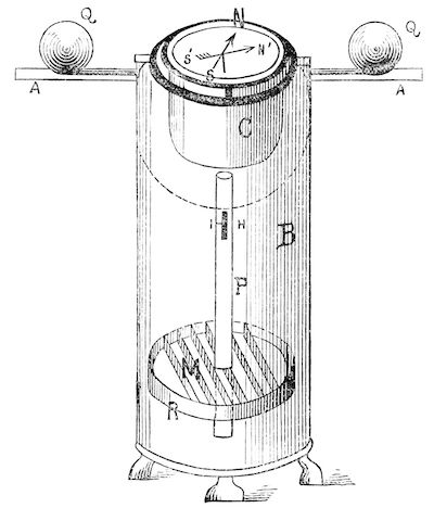
On a large ship, the compass is mounted in a compensating binnacle. In addition to being gimballed to allow for the roll and pitch of the ship, the binnacle includes large solid large iron balls 'Q', which are adjusted to zero-out the compass deviation. Of course, carrying heavy iron balls on an aircraft or a small boat is not practical.
So in addition to the three different names for direction, Course, Heading, and Bearing, there are three different types of direction: True, Magnetic, and Compass. True direction is with respect to true north, magnetic direction is with respect to magnetic north, and compass direction is the uncorrected reading of your compass. All three are related to each other by the correction factors: variation and deviation:
- Magnetic = Compass - Deviation
- True = Magnetic - Variation
British army training: "Grid to Mag: add; Mag to Grid: get rid (subtract)"
- Grid = Mag + Variation
- Mag = Grid - Variation
Where Grid is the map you are using, and Mag is your compass, which in the field should have a deviation of 0, so Compass = Magnetic.
Airport runways are named with the first two digits of their magnetic heading, thus one end might be 32, while the other end is the reciprocal: 14. Owing to changes in the local magnetic variation, runways have to be renamed from time to time.
Confused yet? I'll go easy on you and not even mention compass precession.
GPS
Everything is much simpler with GPS, or Global Positioning System. All directions are true north, and all the magnetic mucky-muck is irrelevant. The only time you need to know magnetic anything is when finding the correct runway in an airplane, and that is usually obvious. GPS can also give you altitude or elevation. One thing GPS can't give you is direction if you are not moving, as it can only compute bearings from changes in position. GPS is based on calculating fantastically fine timing differences of radio signals from orbiting satellites. My phone makes this all so easy, it's disgusting.
Before GPS was a system known as Loran, which also worked by measuring time differences or "TDs" between very accurately timed radio signals, but in this case from ground-based transmitters. Loran generated a very skewed coordinate grid, but was surprisingly accurate for its time, although no two individual Loran receivers ever read exactly the same. The first Loran systems were implemented during World War II. GPS made Loran obsolete, and the Loran transmitting stations were allowed to fail one by one until by the 2000s the system was no longer operational in North America.
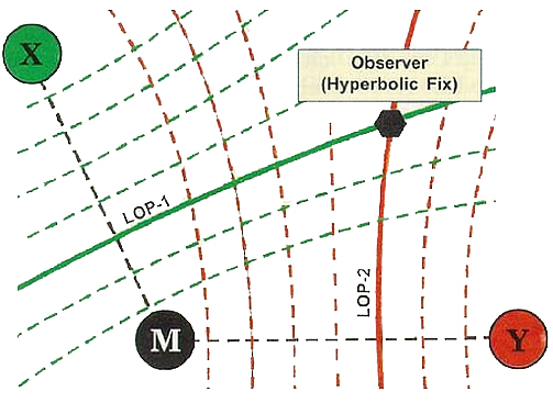
M is the master timing station, X and Y are the transmitting stations. The Loran receiver compared the signals from M to the signals from X and Y to determine its distance from each, which is its location along a specific curve or "TD". The intersection of two "TDs" gave the location. Accuracy was dependent on the orientation of the curves to each other. If more stations were available, they could be used to increase accuracy, but most areas were only covered by two stations. All of this worked very well in an era before satellites and digital computers.
Locally, the TDs were 26xxx running more or less east-west, and 43xxx similarly running north-south. They were typically quoted with one decimal place of accuracy, although an individual Loran unit might be able to repeatably achieve more. Wreck lists were usually ordered by descending 43-number, roughly north to south.
Loran required two ground-based position transmitters and a master timing transmitter to work, and it only gave your position in two dimensions. GPS requires 4 satellites for a good fix ( you can get a less-precise fix with just three ) and will use as many satellites as it can see in the sky, often six. GPS gives your location in three dimensions, ie, you get altitude as well, and is capable of an accuracy measured in feet. Originally, only the military had access to this kind of accuracy, but with "Differential GPS" it became available to anyone. Differential GPS adds civilian ground-based transmitters to bring the system up to military standards. Future systems will have accuracies measured in fractions of inches.
GPS is an American system; the Russians have a comparable system known as GLONASS, and the Europeans are working on a system called Galileo. Galileo is planned to be interoperable with GPS, but GLONASS is not. Future receivers will likely support all three at once, using them to increase accuracy and speed.
Finding a wreck with Loran was something of an art, as it was not perfectly repeatable, even on the same unit. Loran units also had a time lag to them, which meant you had to anticipate the wreck as you motored up to it, while factoring in wind and current. Then you found it on the depth finder, tossed the hook in, drifted back, and felt for it. This was the difference between a good captain and crew, and a not-so-good one. Hardly anyone even knows how to do this anymore. Ahh, the old days ...
Finding a wreck nowadays with GPS is a no-brainer if your numbers are good. I could use my phone, although a tablet or laptop would work better. However, most of the publicly available "GPS" wreck numbers are utter garbage, with the exception of the artificial reefs.
Speed
A knot is one nautical mile per hour. Note that this is a measurement of speed rather than distance, so the often-seen phrase "knots per hour" actually makes no sense. ( Actually, it does make sense - speed/time = acceleration. But the next time you see some TV reporter saying "knots per hour", rest assured they have no idea what they are talking about. ) Because a nautical mile is longer than a statute mile, one knot is significantly faster than 1 mph. So a speedy destroyer making 35 knots is actually going something in excess of 40 mph.
The term knot is derived from the days when a ship's speed was determined by throwing out a drag ( in the earliest days, simply a wooden log ) with a line attached, and counting the amount of line that was paid out over a period of time. Evenly spaced knots were tied in the line for this purpose. Obviously, one knot in the line did not correspond to one nautical mile, but the term has stuck with us through the years, as has the term log, which was originally simply the book in which the measurements of the "log" were kept. "Blog" is a contraction of "web log," obviously by someone who couldn't spell. Most bloggers today think boats go "knots per hour."
Depth
Shallow inshore depths, or soundings, are usually charted in feet. Deeper offshore waters are charted in fathoms. Six feet make up a fathom, which is the standard nautical measure of depth. This was originally derived from the approximate length of one's arm span, a quick and dirty way of measuring a sounding line as you pull it up.