Fisherman
- Type:
- artificial reef, tanker barge
- Specs:
- ( 242 x 42 ft )
- Sponsor:
- Spentonbush Red Star Company, Sportfish Fund
- Sunk:
- Thursday August 7, 1997 - Sea Girt Artificial Reef
- GPS:
- 40°07.930' -73°55.942'
- Depth:
- 70 ft
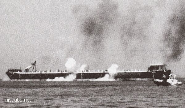
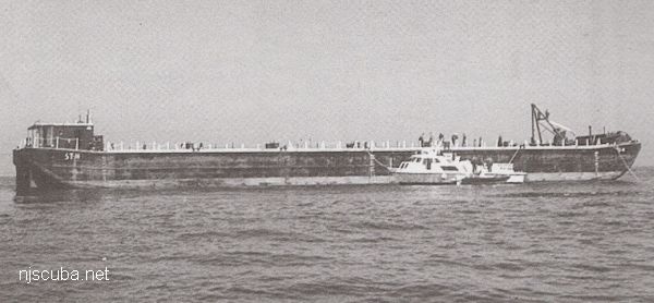
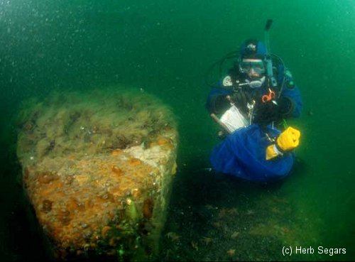
This very big barge was connected to the Rockland County by a heavy hawser or rope. This is the line that was used to moor her to the already-sunk Rockland County while she was prepared for sinking by the demolitions crew. The Fisherman barge is named for the Fisherman magazine, which sponsored her. It was donated to the reef program after the bow was damaged in a collision.
The Fisherman barge is flipped-over, and so presents a smooth upper surface, punctured in places by man-sized holes that probably allow access to the interior. The holes are either the result of the explosives used to sink the barge or were punched through by the large chunks of rock and concrete that were dropped on and around the wreck. The barge also stands slightly off the bottom, not enough to get under, but enough for some nice lobsters to make homes well out of reach.
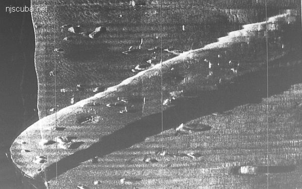
Side-scan sonar image of the Fisherman barge, bow at lower-left, showing blast holes and concrete blocks all around and on the wreck. The side-scan didn't pick up the hawser. I'm sure by now it is gone.

Artificial Reef Sites, Artificial Reefs, Barges, New Jersey Artificial Reef Sites, New Jersey Artificial Reefs, Sea Girt Artificial Reef,
Sea Girt Artificial Reef
- Boy Scout Reef
- car float
- Carlson II
- Cinderella
- Cranford
- drydock
- DVD Barge
- Dykes
- Captain Etzel
- Fisherman Barge
- Golden Eagle
- Horseshoe Wrecks
- Kiley B
- Lewis F Boyer (Travis)
- Liberty Barge 1
- Liberty Barge 2
- Liberty Barge 3
- Liberty Barge 4
- Manasquan Inlet
- Marion
- Matt Turecamo
- Morania 180
- OWD IV
- PATH subway cars
- Railroad barge
- Response
- Restorer
- Rockland County
- Ronde Joyce
- Shark River Inlet
- Smoke II
- Spartan
- Swenson I
- Swenson II
- army tanks
- Wedding Barge
3.6 Nautical Miles off Sea Girt, 1.33 sq miles
Depth: 60-75 ft [download]
More: Sea Girt Artificial Reef ...
Manasquan Chart
- Barge #10
- 120 Wreck
- 3 Sisters
- Ambrose Buoy
- A Street - Shark River
- Across
- Adele
- Ajace
- Alex Mac
- Allenhurst Jetty
- Anastasia
- Antioch
- Arnoff
- Arundo
- Asfalto
- Aurora
- Ayuruoca
- BA Wreck
- Shark River - Back Bay
- Balaena
- Bald Eagle
- Barnegat Inlet
- BD1738
- USS Benson
- Beth Dee Bob
- Blue Boy
- Bonanza
- Brick barge
- Bronx Queen
- Brunette
- Cecilia M Dunlap
- Cornelius Grinnell
- Catherine Jackson
- Chauncy Jerome
- Caddo
- Cadet
- Capt Smitty
- Catamount
- Charlemagne Tower
- Chaparra
- Chesapeake
- Choapa
- clam boat
- Continent
- crane barge
- Creole
- Daghestan
- Delaware
- drydock
- Dryland
- dump
- Duncan
- Edmund Phinney
- Elberon Rocks
- Emerald / USS Hibiscus
- Eureka
- Francis A Perkins
- William R Farrell
- FF Clain
- Finance
- Fort Victoria
- Gassoon
- German
- Lady Gertrude
- GL78
- Glen II
- Glory Wreck
- I.P. Goulandris
- Granite Wreck
- Great Isaac
- Gulftrade (stern)
- Gulftrade (bow)
- Gypsy
- Horseshoe Cove
- Alexander Hamilton
- Hankins (Big)
- Hankins (Offshore)
- Hankins 3
- Happy Days
- Cornelius Hargraves
- Harry Rush
- Harvey's Schooner
- Thomas Hebert
- Ida K
- Immaculata
- Inshore barge/tug
- Irene/Truro
- Irma C
- John Minturn
- Jack I
- Joan La Rie III
- Klondike Rocks
- Lizzie H. Brayton
- Lana Carol
- Larsen
- Lavallette Wreck
- Leon Walter
- Lillian
- Lizzie D
- Long Branch locomotives
- Logwood
- H.W. Long
- Macedonia
- Mahogany
- Malta
- Manasquan Inlet
- Marion
- Maurice Tracy
- Mediator
- Meta
- Middle Barge
- Mistletoe
- R.C. Mohawk
- Mohawk
- Manasquan Wreck
- Nautilus
- Navesink River
- Northeast Sailor
- New Reef
- New Deal
- New Era
- NW Barges
- Olsen
- HMS Pentland Firth
- Park City
- Peerless
- Persephone
- Long Branch Pier Rubble
- Pinta
- Pliny
- Plymouth
- Pocopson
- Remedios Pascual
- Ruth Shaw
- Ramos
- Ranger
- Reliable
- Relief Lightship
- Rickseckers
- Ridge Schooner
- Riggy
- Rjukan
- Rockaway Belle
- Roy's barge
- RP Resor
- Manasquan River Railroad Bridge
- Rudder Wreck - Pocono
- Rump
- Rusland / Adonis
- Scotland Buoy
- San Saba
- Sandy Hook Pilot Boat
- SC-60
- Sea Girt Inlet
- Sea Girt Wreck
- Sea Hag
- Seaside Crane Barge
- Shark River Inlet
- Shrewsbury Rocks
- Simala
- Spring Lake Sailor
- Steel Wreck
- Stolt Dagali
- Sumner
- Southwest Mohawk
- Sylvanus
- Tampa III
- Thurmond
- Tolten
- Train Wheel
- Troop Carrier
- USS Turner
- AWOIS 8087
- AWOIS 8097
- u11
- AWOIS 7509
- AWOIS 7932
- AWOIS 9768
- AWOIS 12966/11422
- AWOIS 1609
- AWOIS 8084
- AWOIS 7940
- AWOIS 7938
- AWOIS 8076
- AWOIS 4600
- AWOIS 8075
- Valerie E
- Vega
- Vivian
- Vizcaya
- Warrior
- Western World
- Edward W Winslow
- Yankee (G+D)
- Yellow Flag
- ZPG-3W
More: Manasquan Dive Sites Chart ...
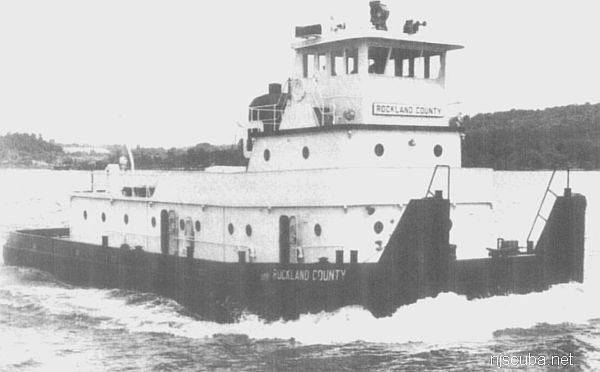
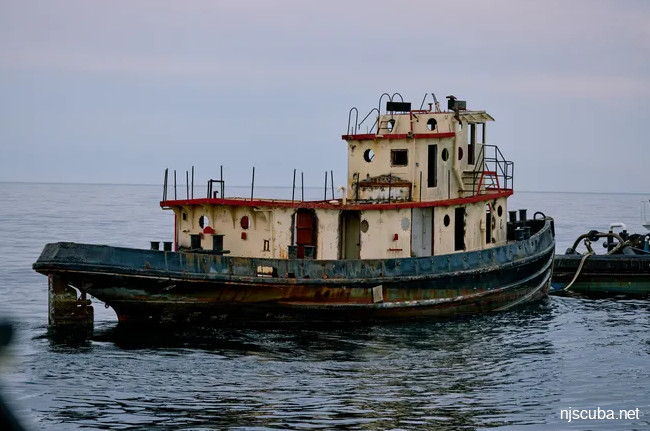
- Type:
- artificial reef, towboat
- Built:
- 1960, Dravo, Wilmington DE USA
- Specs:
- ( 105 x 24 ft )
- Sponsor:
- Spentonbush Red Star Company
- Sunk:
- Friday February 14, 1986 - Sea Girt Artificial Reef
- GPS:
- 40°07.942' -73°55.879'
- Depth:
- 80 ft
More: Rockland County ...
Questions or Inquiries?
Just want to say Hello? Sign the .