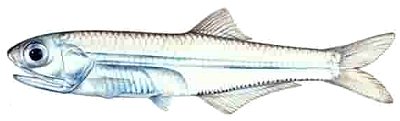
Anchoa mitchilli
Size: to 4"
Habitat: coastal and estuarine waters
Notes: Another small herring-like fish that forms large schools. These, as well as those above, can form huge schools that swirl around the upper reaches of inshore reefs - a sight that easily rivals the tropics. I have seen them school together with the larger and more striking Silver Anchovy. Note the large underslung mouth, which makes identification from other baitfishes easy. Anchovies are physically fragile, yet tolerate an amazing range of environmental conditions. Fishermen call them "Rainfish".
More: Bay Anchovy ...