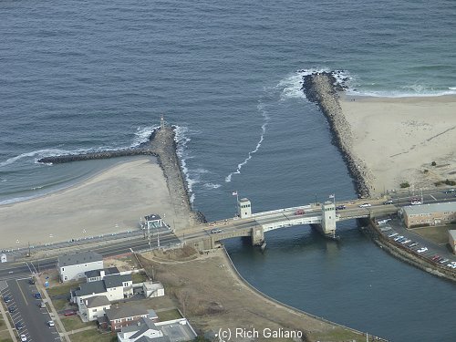
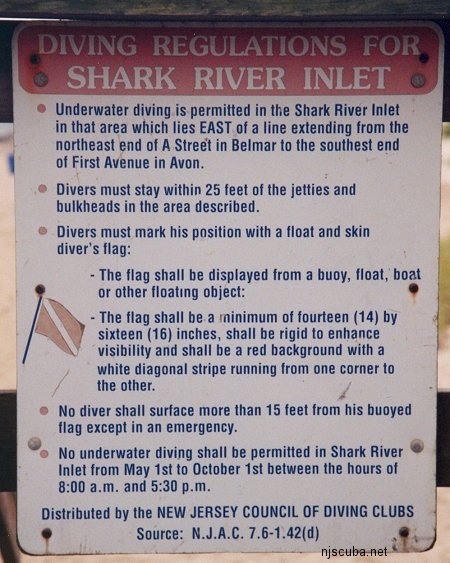
Shark River Inlet
Shark River Inlet
- Type:
- smallish tidal river inlet with stone jetties or bulkheads on both sides
- Depth:
- 15 ft
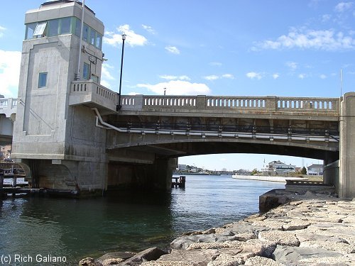
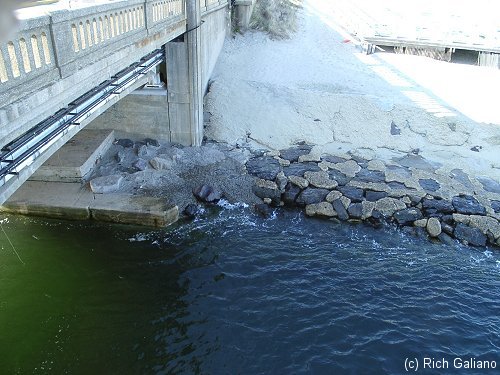
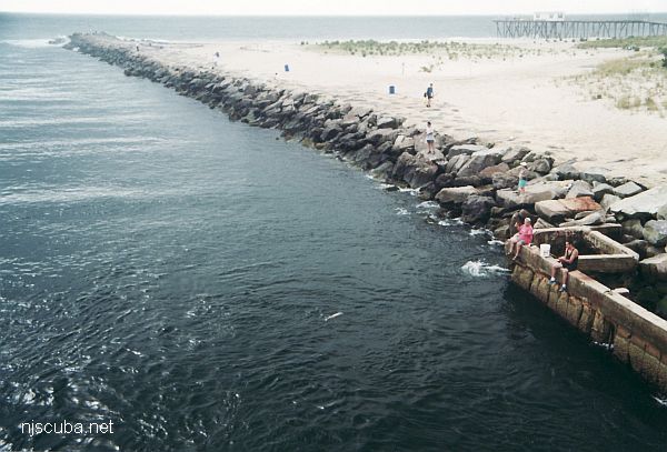
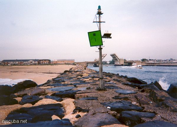
This inlet has an L-shaped jetty on the north side and a longer straight jetty on the south side. Both jetties are made of loose stones - hardly any concrete - and the bottom is sandy and usually clean. You can walk over the bridge from one side of the inlet to the other in about five minutes.
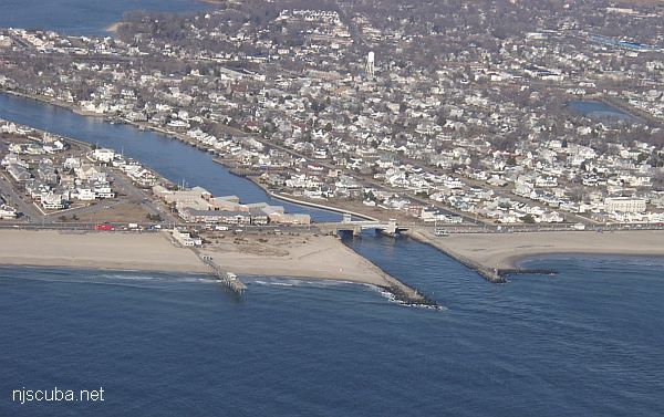
The north side has an easy giant-stride entry into deep water under the bridge, and small rocks to climb out on. For this reason, it is often overrun with O/W students. The south side has a more difficult climb down or up the rocks. Don't do a stride off the concrete wall - you could be impaled on sharp rusty rebar. On both sides, it is possible to climb up the rocks almost anywhere in a pinch, although it may not be easy.

If you get in early, you can ride the current upstream, and then back to your starting point when it reverses. If you are late, you can ride the current out past the end and swim around to the beach, although obviously, this will mean slogging across the sand.
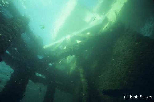
The south side is more interesting than the north side. Around the bridge and for quite a ways upstream, there is a steep rocky slope below the large jetty stones, down to almost 30 feet. This can harbor all kinds of small creatures, and gets covered with a riot of colors by fall. I have seen this area in bright sunny clear conditions and would compare it to a Caribbean wall dive, but days like that are rare. There are also deep spots under the bridge where larger fishes may congregate.
By comparison, on the north side, the jetty stones meet the sandy bottom directly, except where they are replaced by a bulkhead upstream. Directly under the north side of the bridge used to be quite a bit of rubble and debris that could be searched-over, but most of it has been removed by misguided river clean-ups, leaving a much more barren environment. Downstream from the bridge, both sides are pretty much the same - big rocks meeting a sandy bottom; the north side might be a little better for lobsters.
This is my favorite shore dive. The river is generally clean and the visibility is decent. Early in the season, you can catch quite a few lobsters here, but it seems to tail off as the water warms, and by mid to late July it is over. There are also crabs, smallish fluke in the sand, eels, small Blackfish, the ever-present cunners, tropicals late in the season, and all the free fishing sinkers you could want.
Parking is free in Avon on the north side, metered in Belmar on the south, and can be hard to find close by. Either way, you will have to hike a short way with your gear to get to the water. There is a 7-11 store not far south of the bridge where you can get ice, etc; and there are showers on the north side.
Dive Sites, Manasquan Dive Sites, New Jersey Dive Sites, Sandy Hook Dive Sites,
Manasquan Chart
- Barge #10
- 120 Wreck
- 3 Sisters
- Ambrose Buoy
- A Street - Shark River
- Across
- Adele
- Ajace
- Alex Mac
- Allenhurst Jetty
- Anastasia
- Antioch
- Arnoff
- Arundo
- Asfalto
- Aurora
- Ayuruoca
- BA Wreck
- Shark River - Back Bay
- Balaena
- Bald Eagle
- Barnegat Inlet
- BD1738
- USS Benson
- Beth Dee Bob
- Blue Boy
- Bonanza
- Brick barge
- Bronx Queen
- Brunette
- Cecilia M Dunlap
- Cornelius Grinnell
- Catherine Jackson
- Chauncy Jerome
- Caddo
- Cadet
- Capt Smitty
- Catamount
- Charlemagne Tower
- Chaparra
- Chesapeake
- Choapa
- clam boat
- Continent
- crane barge
- Creole
- Daghestan
- Delaware
- drydock
- Dryland
- dump
- Duncan
- Edmund Phinney
- Elberon Rocks
- Emerald / USS Hibiscus
- Eureka
- Francis A Perkins
- William R Farrell
- FF Clain
- Finance
- Fort Victoria
- Gassoon
- German
- Lady Gertrude
- GL78
- Glen II
- Glory Wreck
- I.P. Goulandris
- Granite Wreck
- Great Isaac
- Gulftrade (stern)
- Gulftrade (bow)
- Gypsy
- Horseshoe Cove
- Alexander Hamilton
- Hankins (Big)
- Hankins (Offshore)
- Hankins 3
- Happy Days
- Cornelius Hargraves
- Harry Rush
- Harvey's Schooner
- Thomas Hebert
- Ida K
- Immaculata
- Inshore barge/tug
- Irene/Truro
- Irma C
- John Minturn
- Jack I
- Joan La Rie III
- Klondike Rocks
- Lizzie H. Brayton
- Lana Carol
- Larsen
- Lavallette Wreck
- Leon Walter
- Lillian
- Lizzie D
- Long Branch locomotives
- Logwood
- H.W. Long
- Macedonia
- Mahogany
- Malta
- Manasquan Inlet
- Marion
- Maurice Tracy
- Mediator
- Meta
- Middle Barge
- Mistletoe
- R.C. Mohawk
- Mohawk
- Manasquan Wreck
- Nautilus
- Navesink River
- Northeast Sailor
- New Reef
- New Deal
- New Era
- NW Barges
- Olsen
- HMS Pentland Firth
- Park City
- Peerless
- Persephone
- Long Branch Pier Rubble
- Pinta
- Pliny
- Plymouth
- Pocopson
- Remedios Pascual
- Ruth Shaw
- Ramos
- Ranger
- Reliable
- Relief Lightship
- Rickseckers
- Ridge Schooner
- Riggy
- Rjukan
- Rockaway Belle
- Roy's barge
- RP Resor
- Manasquan River Railroad Bridge
- Rudder Wreck - Pocono
- Rump
- Rusland / Adonis
- Scotland Buoy
- San Saba
- Sandy Hook Pilot Boat
- SC-60
- Sea Girt Inlet
- Sea Girt Wreck
- Sea Hag
- Seaside Crane Barge
- Shark River Inlet
- Shrewsbury Rocks
- Simala
- Spring Lake Sailor
- Steel Wreck
- Stolt Dagali
- Sumner
- Southwest Mohawk
- Sylvanus
- Tampa III
- Thurmond
- Tolten
- Train Wheel
- Troop Carrier
- USS Turner
- AWOIS 8087
- AWOIS 8097
- u11
- AWOIS 7509
- AWOIS 7932
- AWOIS 9768
- AWOIS 12966/11422
- AWOIS 1609
- AWOIS 8084
- AWOIS 7940
- AWOIS 7938
- AWOIS 8076
- AWOIS 4600
- AWOIS 8075
- Valerie E
- Vega
- Vivian
- Vizcaya
- Warrior
- Western World
- Edward W Winslow
- Yankee (G+D)
- Yellow Flag
- ZPG-3W
More: Manasquan Dive Sites Chart ...
- Type:
- smallish tidal river inlet with stone jetties or bulkheads on both sides
- Depth:
- 15 ft
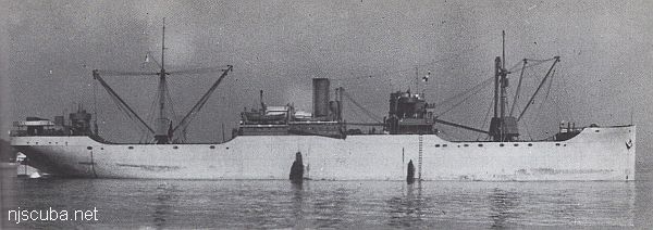
The Shark River is your best bet for shore diving in the northern half of the New Jersey coastline, far better than the Manasquan River. Shark River offers at least four different locations to dive: either side of the inlet, with rock jetties to explore, slightly upstream at A Street in Belmar, and upriver in the back bay area at L Street, Belmar. The wreck of the Malta is also just a few blocks south on the beach, but hardly worth diving.
More: Shark River ...
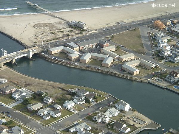
Yet another place to dive the Shark River is on the south side, near the intersection of 1st Avenue and A Street, behind the apartments. There is limited but very convenient free parking. A small cement stairway leads down to a concrete ledge above the water. Climb down between the big rock and the bulkhead, where you will find more steps underwater. ( Whoever B.M and M.M. are - thank you! )
More: Shark River - A Street ...
- Type:
- inland tidal bay
- Depth:
- 20 ft max, 15 ft in most places
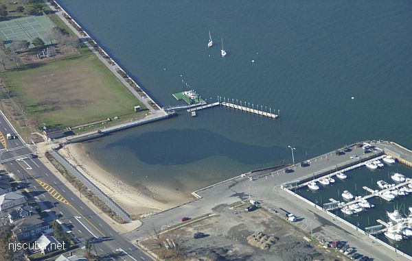
This dive site, formerly known as 'L Street' has changed completely, and for the better. The town of Belmar has done something really nice for us divers and installed wide wooden steps down the bulkhead in Maclearie Park. This more than makes up for the loss of the boat ramp area, which is off-limits to all swimmers since it was rebuilt. I suppose the little cove by the ramp is still accessible from the beach, but the new site is much better, and far from all the dangerous boat traffic around the ramp and marina.
More: Shark River - Back Bay ...
Sandy Hook / Rockaway Inlet Chart
- Barge #10
- 120 Wreck
- 3 Sisters
- Ambrose Buoy
- A Street - Shark River
- Acara
- Across
- Adele
- Ajace
- Alex Mac
- Allenhurst Jetty
- Antioch
- Arnoff
- Arundo
- Asfalto
- Aurora
- Ayuruoca
- BA Wreck
- Shark River - Back Bay
- Balaena
- Bald Eagle
- BD1738
- USS Benson
- Beth Dee Bob
- Blue Boy
- Bronx Queen
- Bug Light
- Charles Dunlap
- Cecilia M Dunlap
- Catherine Jackson
- Chauncy Jerome
- Cornelia Soule
- Choapa
- coal (Lido)
- Continent
- crane barge
- Daghestan
- Dragger
- drydock
- Dryland
- Edwin Duke / Stone Barge
- dump
- Dutch Springs
- Edmund Phinney
- East Rockaway Inlet
- Ed's Schooner
- Elberon Rocks
- Eureka
- Finance
- Fort Victoria
- German
- GL78
- Glen II
- I.P. Goulandris
- Gypsy
- Horseshoe Cove
- Alexander Hamilton
- Howard
- Iberia
- Immaculata
- Inshore Schooner
- Jack I
- Joan La Rie III
- Jones Inlet
- Jones Tug
- Klondike Rocks
- Larsen
- Lizzie D
- Long Branch locomotives
- Logwood
- H.W. Long
- Macedonia
- Mahogany
- Malta
- Manasquan Inlet
- Margaret
- Marion
- Mistletoe
- R.C. Mohawk
- Manasquan Wreck
- Nautilus
- Navesink River
- Northeast Sailor
- New Reef
- New Deal
- New Era
- HMS Pentland Firth
- Long Branch Pier Rubble
- Pinta
- Pipe Barge
- Pliny
- Plymouth
- Pocopson
- Princess Anne
- Ruth Shaw
- Robert A Snow
- Ramos
- Ranger
- Relief Lightship
- Rickseckers
- Rjukan
- Rockaway Inlet
- Rockaway Belle
- Round Valley
- Roy's barge
- Rudder Wreck - Pocono
- Rusland / Adonis
- Scotland Buoy
- Sandy Hook Pilot Boat
- SC-60
- Sea Girt Inlet
- Sea Girt Wreck
- Shark River Inlet
- Shrewsbury Rocks
- Spring Lake Sailor
- Steel Wreck
- Stolt Dagali
- Sylvanus
- Tampa III
- USS Turner
- AWOIS 8087
- AWOIS 8097
- u11
- AWOIS 7509
- AWOIS 7932
- AWOIS 9768
- AWOIS 12966/11422
- AWOIS 1609
- AWOIS 8084
- AWOIS 7940
- AWOIS 7938
- AWOIS 8076
- AWOIS 4600
- AWOIS 8075
- Valerie E
- Vega
- Warrior
- Delaware River Water Gap
- Western World
- Edward W Winslow
More: Sandy Hook Dive Sites Chart ...
Questions or Inquiries?
Just want to say Hello? Sign the .