
SW Mohawk "Coffee"

Shipwreck Southwest Mohawk
Type:
shipwreck, sailing ship
Depth:
75 ft

The "Southwest Mohawk" or "Coffee Wreck" is nothing like its namesake. Artifacts found on the wreck indicated that it was a late eighteenth-century sailing ship and not a barge.

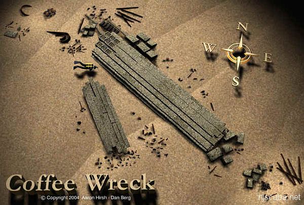
An assembly of fairly large timbers forms a low solid deck over most of the wreck, with bundles of iron pipes and stone ballast blocks scattered around. The bottom is clean, white, almost Caribbean sand. Visibility tends to be relatively good, and it is very easy to follow around the edges of the wreck or explore over the top without getting lost. Caverns and gaps around the edges of the wreckage provide homes for swarms of Sea Bass, some of them huge, and a few Tautogs.

Captain John Bogan recounts the naming of the wreck:

My dad ran the Shamrock out of Broadway (Point Pleasant), where the Dauntless is today. My brother Bob was first and sometimes second mate. He used to drive my father crazy when he'd ask, "What spot is this, what spot are we going to?" Dad had been fishing the Mohawk and was heading towards Hankins. A commercial fisherman/friend held up 2 giant blackfish when he was going by. Dad slowed, and just off the buoys drifted over and found the wreck. My brother, as usual, was giving him the third degree. So dad said, "This is the Coffee Ground spot."

Drawing courtesy of Aaron Hirsh

Comments on SW Mohawk

Questions or Inquiries?

Just want to say Hello? Sign the .

Submit a Comment

Your email address will not be published. Required fields are marked *


Click image to replace if unable to read.

Enter the digits from the image above, except for the last one:

This site uses Akismet to reduce spam. Learn how your comment data is processed.


from AWOIS: 1607

NM47/66 -- DANGEROUS WRECK OF DREDGE DRYLAND, 62 FT. LONG. 22 FT. WIDE REPORTED SUNK IN ABOUT 90 FT. COVERED ABOUT 55 FT.

CL1540/78 -- MAR, OPR-C622-RU/HE-78; ITEM 4; INVESTIGATION BEGAN 30 AUGUST AND WAS COMPLETED ON 18 SEPTEMBER. EFFECTIVELY CLEARED TO MIN. OF 45.5 FT., (38.5 FT. ON A 40 FT. SHOAL), WITH NO HANGS ENCOUNTERED.

FE221/78-79 -- OPR-C622-RU/HE; ITEM 4; REQUIRED CLEARANCE TO 45 FT. DUE TO POSSIBLE HAZARDS ON THE BOTTOM. 1 MILE, RADIUS CIRCLE DRAGGED TO 45 FT. EXCEPT TO 38 FT. ON 40 FT. SHOAL (SEE AWOIS NO.00752) NW OF AMBROSE LIGHT TOWER. NO HANGS ENCOUNTERED. RECOMMENDED THAT CLEARED AREA BE CHARTED WITH GREEN TINT WITH 45 FT. CLEARANCE NOTE WHERE APPROPRIATE.

H10224/86-87 -- OPR-C121-WH-86-87; WRECK FOUND DURING MAIN SCHEME HYDROGRAPHY AND SIDE-SCAN SONAR OPERATION 850M EAST OF REPORTED POSITION; SIX DIVES PERFORMED; 2-15 FT VISIBILITY; PNEUMATIC DEPTH GAUGE LEAST DEPTH OF 86 FT TAKEN ON TOP OF A 20 FT LONG DREDGE PIPE FLOAT FOUND 841.6M EAST OF AWOIS POSITION; WRECK SITE REVEALED PIPES, FLOATS, AND DREDGING EQUIPMENT. (UPDATED MSD 4/91)