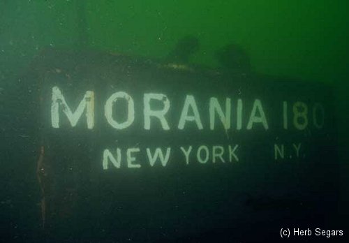
Morania 180
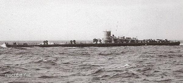
- Type:
- artificial reef, barge
- Built:
- 1961, Bethlehem Beaumont, Beaumont TX USA
- Specs:
- ( 230 ft )
- Sponsor:
- Morania Oil Company
- Sunk:
- Monday June 6, 1988 - Sea Girt Artificial Reef
- GPS:
- 40°06.301' -73°57.424'
- Depth:
- 75 ft
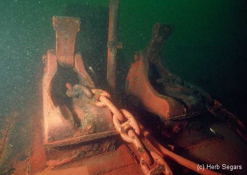
This is a very big flat-topped asphalt tanker barge. The stern is the most interesting area, with a small platform and myriad big pipes and valves, and a big notch in the transom where the tugboat would go. Good spearfishing in this area as well. The bow of the barge is less interesting. A number of open hatches in the deck at 65 ft allow access to the interior, which is very dark.
285129
Artificial Reef Sites, Artificial Reefs, Barges, New Jersey Artificial Reef Sites, New Jersey Artificial Reefs, Sea Girt Artificial Reef,
Sea Girt Artificial Reef
- Boy Scout Reef
- car float
- Carlson II
- Cinderella
- Cranford
- drydock
- DVD Barge
- Dykes
- Captain Etzel
- Fisherman Barge
- Golden Eagle
- Horseshoe Wrecks
- Kiley B
- Lewis F Boyer (Travis)
- Liberty Barge 1
- Liberty Barge 2
- Liberty Barge 3
- Liberty Barge 4
- Manasquan Inlet
- Marion
- Matt Turecamo
- Morania 180
- OWD IV
- PATH subway cars
- Railroad barge
- Response
- Restorer
- Rockland County
- Ronde Joyce
- Shark River Inlet
- Smoke II
- Spartan
- Swenson I
- Swenson II
- army tanks
- Wedding Barge
3.6 Nautical Miles off Sea Girt, 1.33 sq miles
Depth: 60-75 ft [download]
More: Sea Girt Artificial Reef ...
Manasquan Chart
- Barge #10
- 120 Wreck
- 3 Sisters
- Ambrose Buoy
- A Street - Shark River
- Across
- Adele
- Ajace
- Alex Mac
- Allenhurst Jetty
- Anastasia
- Antioch
- Arnoff
- Arundo
- Asfalto
- Aurora
- Ayuruoca
- BA Wreck
- Shark River - Back Bay
- Balaena
- Bald Eagle
- Barnegat Inlet
- BD1738
- USS Benson
- Beth Dee Bob
- Blue Boy
- Bonanza
- Brick barge
- Bronx Queen
- Brunette
- Cecilia M Dunlap
- Cornelius Grinnell
- Catherine Jackson
- Chauncy Jerome
- Caddo
- Cadet
- Capt Smitty
- Catamount
- Charlemagne Tower
- Chaparra
- Chesapeake
- Choapa
- clam boat
- Continent
- crane barge
- Creole
- Daghestan
- Delaware
- drydock
- Dryland
- dump
- Duncan
- Edmund Phinney
- Elberon Rocks
- Emerald / USS Hibiscus
- Eureka
- Francis A Perkins
- William R Farrell
- FF Clain
- Finance
- Fort Victoria
- Gassoon
- German
- Lady Gertrude
- GL78
- Glen II
- Glory Wreck
- I.P. Goulandris
- Granite Wreck
- Great Isaac
- Gulftrade (stern)
- Gulftrade (bow)
- Gypsy
- Horseshoe Cove
- Alexander Hamilton
- Hankins (Big)
- Hankins (Offshore)
- Hankins 3
- Happy Days
- Cornelius Hargraves
- Harry Rush
- Harvey's Schooner
- Thomas Hebert
- Ida K
- Immaculata
- Inshore barge/tug
- Irene/Truro
- Irma C
- John Minturn
- Jack I
- Joan La Rie III
- Klondike Rocks
- Lizzie H. Brayton
- Lana Carol
- Larsen
- Lavallette Wreck
- Leon Walter
- Lillian
- Lizzie D
- Long Branch locomotives
- Logwood
- H.W. Long
- Macedonia
- Mahogany
- Malta
- Manasquan Inlet
- Marion
- Maurice Tracy
- Mediator
- Meta
- Middle Barge
- Mistletoe
- R.C. Mohawk
- Mohawk
- Manasquan Wreck
- Nautilus
- Navesink River
- Northeast Sailor
- New Reef
- New Deal
- New Era
- NW Barges
- Olsen
- HMS Pentland Firth
- Park City
- Peerless
- Persephone
- Long Branch Pier Rubble
- Pinta
- Pliny
- Plymouth
- Pocopson
- Remedios Pascual
- Ruth Shaw
- Ramos
- Ranger
- Reliable
- Relief Lightship
- Rickseckers
- Ridge Schooner
- Riggy
- Rjukan
- Rockaway Belle
- Roy's barge
- RP Resor
- Manasquan River Railroad Bridge
- Rudder Wreck - Pocono
- Rump
- Rusland / Adonis
- Scotland Buoy
- San Saba
- Sandy Hook Pilot Boat
- SC-60
- Sea Girt Inlet
- Sea Girt Wreck
- Sea Hag
- Seaside Crane Barge
- Shark River Inlet
- Shrewsbury Rocks
- Simala
- Spring Lake Sailor
- Steel Wreck
- Stolt Dagali
- Sumner
- Southwest Mohawk
- Sylvanus
- Tampa III
- Thurmond
- Tolten
- Train Wheel
- Troop Carrier
- USS Turner
- AWOIS 8087
- AWOIS 8097
- u11
- AWOIS 7509
- AWOIS 7932
- AWOIS 9768
- AWOIS 12966/11422
- AWOIS 1609
- AWOIS 8084
- AWOIS 7940
- AWOIS 7938
- AWOIS 8076
- AWOIS 4600
- AWOIS 8075
- Valerie E
- Vega
- Vivian
- Vizcaya
- Warrior
- Western World
- Edward W Winslow
- Yankee (G+D)
- Yellow Flag
- ZPG-3W
More: Manasquan Dive Sites Chart ...

Questions or Inquiries?
Just want to say Hello? Sign the .