
Hudson/East Rivers
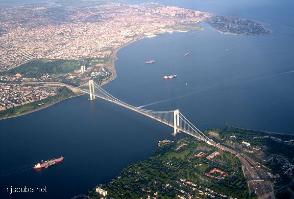
Looking roughly south: Sandy Hook is barely visible at upper-right, Rockaway inlet at the upper-left, Brooklyn at lower-left, Staten Island at lower-right. The shipping channel is also plainly obvious.
Hudson River
Dive Sites, Long Island West Dive Sites, New Jersey Dive Sites, New York Dive Sites, Sandy Hook Dive Sites,
Long Island - Central Chart
- 3 Sisters
- 3/4 Tug
- 59-Pounder
- Acara
- Across
- Arnoff
- Arundo
- Asfalto
- Ayuruoca
- BA Wreck
- Balaena
- Bald Eagle
- USS Benson
- Beth Dee Bob
- Blue Boy
- Burnside
- Catamount
- Choapa
- coal (Lido)
- Coastwise
- Continent
- Dodger
- Dragger
- Drumelzier
- drydock
- Edwin Duke / Stone Barge
- dump
- East Rockaway Inlet
- Eureka
- Fire Island Inlet
- Gate City
- Gluckauf
- I.P. Goulandris
- Gypsy
- Happy Days
- Harvey's Schooner
- Howard
- Hylton Castle
- Iberia
- Immaculata
- Irma C
- Jones Inlet
- Jones Tug
- Kenosha
- Kismet Artificial Reef
- Larsen
- Linda
- Lizzie D
- Margaret
- R.C. Mohawk
- Moriches Inlet
- Old Yankee
- Oregon
- Pipe Barge
- Ponquogue Bridge
- Ruth Shaw
- Reggie
- Rockaway Belle
- Roda
- USS San Diego
- SC-209
- Sea Wolf
- Shinnecock Inlet
- Sommerstad
- Steel Wreck
- Stolt Dagali
- USS Tarantula
- Train Wheel
- Valerie E
- Wolcott
- Yankee (G+D)
- Yellowbar Artificial Reef
More: Long Island Central Dive Sites Chart ...
Sandy Hook / Rockaway Inlet Chart
- Barge #10
- 120 Wreck
- 3 Sisters
- Ambrose Buoy
- A Street - Shark River
- Acara
- Across
- Adele
- Ajace
- Alex Mac
- Allenhurst Jetty
- Antioch
- Arnoff
- Arundo
- Asfalto
- Aurora
- Ayuruoca
- BA Wreck
- Shark River - Back Bay
- Balaena
- Bald Eagle
- BD1738
- USS Benson
- Beth Dee Bob
- Blue Boy
- Bronx Queen
- Bug Light
- Charles Dunlap
- Cecilia M Dunlap
- Catherine Jackson
- Chauncy Jerome
- Cornelia Soule
- Choapa
- coal (Lido)
- Continent
- crane barge
- Daghestan
- Dragger
- drydock
- Dryland
- Edwin Duke / Stone Barge
- dump
- Dutch Springs
- Edmund Phinney
- East Rockaway Inlet
- Ed's Schooner
- Elberon Rocks
- Eureka
- Finance
- Fort Victoria
- German
- GL78
- Glen II
- I.P. Goulandris
- Gypsy
- Horseshoe Cove
- Alexander Hamilton
- Howard
- Iberia
- Immaculata
- Inshore Schooner
- Jack I
- Joan La Rie III
- Jones Inlet
- Jones Tug
- Klondike Rocks
- Larsen
- Lizzie D
- Long Branch locomotives
- Logwood
- H.W. Long
- Macedonia
- Mahogany
- Malta
- Manasquan Inlet
- Margaret
- Marion
- Mistletoe
- R.C. Mohawk
- Manasquan Wreck
- Nautilus
- Navesink River
- Northeast Sailor
- New Reef
- New Deal
- New Era
- HMS Pentland Firth
- Long Branch Pier Rubble
- Pinta
- Pipe Barge
- Pliny
- Plymouth
- Pocopson
- Princess Anne
- Ruth Shaw
- Robert A Snow
- Ramos
- Ranger
- Relief Lightship
- Rickseckers
- Rjukan
- Rockaway Inlet
- Rockaway Belle
- Round Valley
- Roy's barge
- Rudder Wreck - Pocono
- Rusland / Adonis
- Scotland Buoy
- Sandy Hook Pilot Boat
- SC-60
- Sea Girt Inlet
- Sea Girt Wreck
- Shark River Inlet
- Shrewsbury Rocks
- Spring Lake Sailor
- Steel Wreck
- Stolt Dagali
- Sylvanus
- Tampa III
- USS Turner
- AWOIS 8087
- AWOIS 8097
- u11
- AWOIS 7509
- AWOIS 7932
- AWOIS 9768
- AWOIS 12966/11422
- AWOIS 1609
- AWOIS 8084
- AWOIS 7940
- AWOIS 7938
- AWOIS 8076
- AWOIS 4600
- AWOIS 8075
- Valerie E
- Vega
- Warrior
- Delaware River Water Gap
- Western World
- Edward W Winslow
More: Sandy Hook Dive Sites Chart ...
Raritan Bay
This bay is muddy and turbid, although some folks dive the several small wrecks around the inside of Sandy Hook. Bottle hunting around the old piers and pilings in Keyport harbor is also a possibility, but most of the structures along the bay shore are too small and shallow to be of interest. I have scouted the shoreline from Atlantic Highlands to Laurence Harbor, and nothing looks too promising. See also entries on Navesink River and Horseshoe Cove.
More: Raritan Bay ...
Questions or Inquiries?
Just want to say Hello? Sign the .