Long Island Central Dive Sites Chart
Long Island - Central Chart
- 3 Sisters
- 3/4 Tug
- 59-Pounder
- Acara
- Across
- Arnoff
- Arundo
- Asfalto
- Ayuruoca
- BA Wreck
- Balaena
- Bald Eagle
- USS Benson
- Beth Dee Bob
- Blue Boy
- Burnside
- Catamount
- Choapa
- coal (Lido)
- Coastwise
- Continent
- Dodger
- Dragger
- Drumelzier
- drydock
- Edwin Duke / Stone Barge
- dump
- East Rockaway Inlet
- Eureka
- Fire Island Inlet
- Gate City
- Gluckauf
- I.P. Goulandris
- Gypsy
- Happy Days
- Harvey's Schooner
- Howard
- Hylton Castle
- Iberia
- Immaculata
- Irma C
- Jones Inlet
- Jones Tug
- Kenosha
- Kismet Artificial Reef
- Larsen
- Linda
- Lizzie D
- Margaret
- R.C. Mohawk
- Moriches Inlet
- Old Yankee
- Oregon
- Pipe Barge
- Ponquogue Bridge
- Ruth Shaw
- Reggie
- Rockaway Belle
- Roda
- USS San Diego
- SC-209
- Sea Wolf
- Shinnecock Inlet
- Sommerstad
- Steel Wreck
- Stolt Dagali
- USS Tarantula
- Train Wheel
- Valerie E
- Wolcott
- Yankee (G+D)
- Yellowbar Artificial Reef
- 3/4 Tug
- 59-Pounder
- Acara
- Ajace
- Arnoff
- Asfalto
- Atlantic Beach Reef ...
- Ayuruoca
- BA Wreck
- Bald Eagle
- Beach Jetties
- Black Warrior
- Bronx Queen
- Bug Light
- Burnside
- Celtic / Cape Race
- Charles Dunlap
- Choapa
- Coastwise
- Coimbra
- Condor
- Continent
- Cornelia Soule
- Dodger
- Dragger
- Drumelzier
- drydock barge
- E. Rockaway Inlet / 8th St
- Ed's Schooner
- Edwin Duke
- Eureka
- Fire Island Inlet
- Fire Island Reef ...
- Fort Victoria
- Glen Island
- Gluckauf
- Goulandris
- Gwendoline Steers
- Happy Days
- Harvey's Schooner
- Hempstead Reef ...
- Howard
- Hudson/East Rivers
- Hylton Castle
- Iberia
- Immaculata
- Inshore Schooner
- Irma C
- Jones Inlet / Wreck
- Kenosha
- Kismet Reef ...
- Lexington
- Lido (Coal Wreck)
- Linda
- Lizzie D
- Long Island Sound Chart ...
- Macedonia
- Maine
- Margaret
- McAllister Reef ...
- Mistletoe
- Moriches Reef ...
- Mud Hole
- Myronus
- New Deal
- Oregon
- Pinta
- Pipe Barge
- Poling Brothers #2
- Princess Anne
- R.C. Mohawk
- Reggie
- Relief Lightship
- Rickseckers
- Robert A Snow
- Rockaway Inlet
- Rockaway Reef ...
- Roda
- Ruth Shaw
- Sandy Hook Pilot
- Sandy Hook Reef ...
- Seawolf
- Shark River Reef ...
- Shrewsbury Rocks
- Steel Wreck
- Stolt Dagali
- Three Sisters
- Train Wheel Wreck
- USS Algol
- USS San Diego
- USS Tarantula
- USS Turner
- Valerie E
- Wolcott
- Yankee (G&D)
- Yankee (Old)
- Yellowbar Reef ...
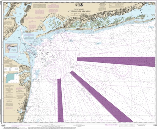
Rockaway Artificial Reef
1.6 nautical miles south of Rockaway Beach, 1.00 sq miles
Depth: 32 - 40 ft
More: Rockaway Artificial Reef ...
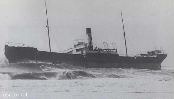
- Type:
- shipwreck, collier, USA
- Name:
- Kenosha, the seat of Kenosha County, is a city in southeastern Wisconsin on Lake Michigan.
- Built:
- 1894, Davidson Shipbuilding, West Bay City MI USA, as Madagascar
- Specs:
- ( 244 x 37 ft ) 1677 gross tons, 12 crew
- Sunk:
- Saturday July 24, 1909
foundered in storm - no casualties - Depth:
- 100 ft
More: Kenosha ...
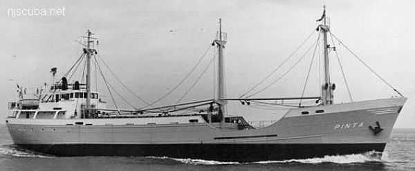
- Type:
- shipwreck, freighter, Netherlands
- Name:
- The Pinta was one of three sister ships named for Columbus' original three vessels, the Nina, the Pinta, and the Santa Maria.
- Built:
- 1959, Denmark
- Specs:
- ( 194 x 31 ft ) 1000 gross tons, 12 crew
- Sunk:
- Wednesday May 8, 1963
collision with freighter City of Perth ( 7547 tons) - no casualties - GPS:
- 40°13.827' -73°50.625' (AWOIS 1988)
- Depth:
- 85 ft, starts at 55 ft
More: Pinta ...
- Type:
- shipwreck, schooner
- Depth:
- 120 ft
The Harvey's Woody is an unidentified wooden schooner that sits in 120 feet of water about 24 miles out of Jones Inlet NY. According to diver Jim Fazzolare diver can find not only low lying ribs but a large pile of anchor chain, a large fluted anchor, and winch. This wreck is excellent for lobsters.
More: Harvey's Schooner ...