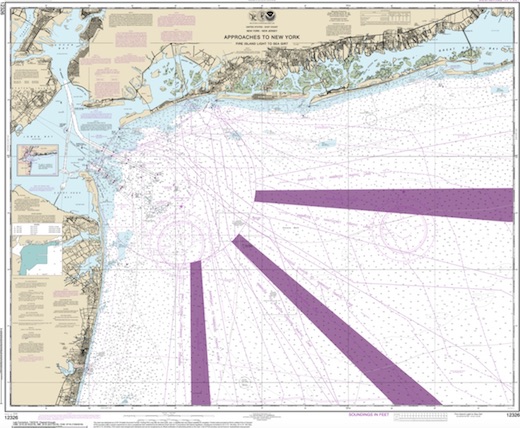
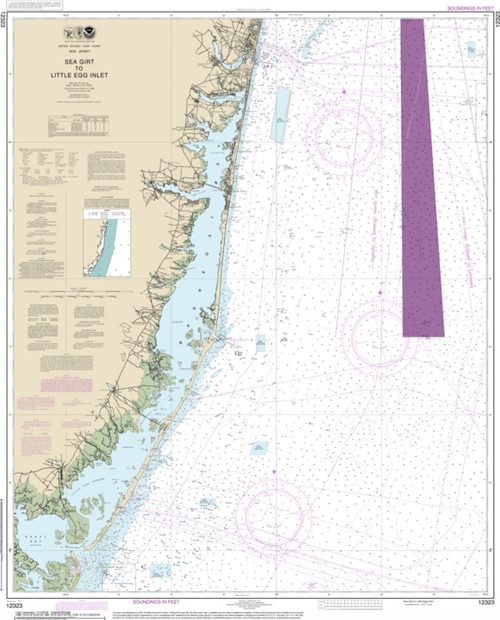
Manasquan Dive Sites Chart
Manasquan Chart
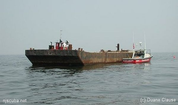
- Barge #10
- 120 Wreck
- 3 Sisters
- Ambrose Buoy
- A Street - Shark River
- Across
- Adele
- Ajace
- Alex Mac
- Allenhurst Jetty
- Anastasia
- Antioch
- Arnoff
- Arundo
- Asfalto
- Aurora
- Ayuruoca
- BA Wreck
- Shark River - Back Bay
- Balaena
- Bald Eagle
- Barnegat Inlet
- BD1738
- USS Benson
- Beth Dee Bob
- Blue Boy
- Bonanza
- Brick barge
- Bronx Queen
- Brunette
- Cecilia M Dunlap
- Cornelius Grinnell
- Catherine Jackson
- Chauncy Jerome
- Caddo
- Cadet
- Capt Smitty
- Catamount
- Charlemagne Tower
- Chaparra
- Chesapeake
- Choapa
- clam boat
- Continent
- crane barge
- Creole
- Daghestan
- Delaware
- drydock
- Dryland
- dump
- Duncan
- Edmund Phinney
- Elberon Rocks
- Emerald / USS Hibiscus
- Eureka
- Francis A Perkins
- William R Farrell
- FF Clain
- Finance
- Fort Victoria
- Gassoon
- German
- Lady Gertrude
- GL78
- Glen II
- Glory Wreck
- I.P. Goulandris
- Granite Wreck
- Great Isaac
- Gulftrade (stern)
- Gulftrade (bow)
- Gypsy
- Horseshoe Cove
- Alexander Hamilton
- Hankins (Big)
- Hankins (Offshore)
- Hankins 3
- Happy Days
- Cornelius Hargraves
- Harry Rush
- Harvey's Schooner
- Thomas Hebert
- Ida K
- Immaculata
- Inshore barge/tug
- Irene/Truro
- Irma C
- John Minturn
- Jack I
- Joan La Rie III
- Klondike Rocks
- Lizzie H. Brayton
- Lana Carol
- Larsen
- Lavallette Wreck
- Leon Walter
- Lillian
- Lizzie D
- Long Branch locomotives
- Logwood
- H.W. Long
- Macedonia
- Mahogany
- Malta
- Manasquan Inlet
- Marion
- Maurice Tracy
- Mediator
- Meta
- Middle Barge
- Mistletoe
- R.C. Mohawk
- Mohawk
- Manasquan Wreck
- Nautilus
- Navesink River
- Northeast Sailor
- New Reef
- New Deal
- New Era
- NW Barges
- Olsen
- HMS Pentland Firth
- Park City
- Peerless
- Persephone
- Long Branch Pier Rubble
- Pinta
- Pliny
- Plymouth
- Pocopson
- Remedios Pascual
- Ruth Shaw
- Ramos
- Ranger
- Reliable
- Relief Lightship
- Rickseckers
- Ridge Schooner
- Riggy
- Rjukan
- Rockaway Belle
- Roy's barge
- RP Resor
- Manasquan River Railroad Bridge
- Rudder Wreck - Pocono
- Rump
- Rusland / Adonis
- Scotland Buoy
- San Saba
- Sandy Hook Pilot Boat
- SC-60
- Sea Girt Inlet
- Sea Girt Wreck
- Sea Hag
- Seaside Crane Barge
- Shark River Inlet
- Shrewsbury Rocks
- Simala
- Spring Lake Sailor
- Steel Wreck
- Stolt Dagali
- Sumner
- Southwest Mohawk
- Sylvanus
- Tampa III
- Thurmond
- Tolten
- Train Wheel
- Troop Carrier
- USS Turner
- AWOIS 8087
- AWOIS 8097
- u11
- AWOIS 7509
- AWOIS 7932
- AWOIS 9768
- AWOIS 12966/11422
- AWOIS 1609
- AWOIS 8084
- AWOIS 7940
- AWOIS 7938
- AWOIS 8076
- AWOIS 4600
- AWOIS 8075
- Valerie E
- Vega
- Vivian
- Vizcaya
- Warrior
- Western World
- Edward W Winslow
- Edward W Winslow
- Yankee (G+D)
- Yellow Flag
- ZPG-3W
- 120 Wreck
- Across Wreck
- Adele
- Alex Mac
- Allenhurst Jetty
- Anastasia
- Antioch
- Arundo
- Axel Carlson Reef ...
- Ayrshire
- Ayuruoca
- Balaena
- Barge #10
- Barnegat Bay
- Beach Jetties
- Benson
- Beth Dee Bob
- Blue Boy
- Bluff's Wreck
- Bonanza
- Brunette
- Cadet
- Capt. Smitty
- Catherine Jackson
- Charlemagne Tower
- clam boat
- Delaware
- drydock barge
- Duncan
- Edward W. Winslow
- Ellie B
- Emerald
- Francis A Perkins
- Gassoon
- German
- Glory Wreck
- Goulandris
- Granite Wreck
- Gulf Trade
- Gypsy
- Hankins Wrecks
- Ida K SC-1282
- Irene/Truro
- Joan LaRie III
- John Minturn
- Klondike Rocks
- Lana Carol
- Larsen
- Lavallette Wreck
- Leon Walter
- Lillian
- Lizzie H. Brayton
- Logwood
- Mahogany
- Malta
- Manasquan Inlet
- Manasquan Reef ...
- Manasquan River
- Manasquan Wreck
- Marion
- Maurice Tracy
- Meta
- Middle Barge
- Mohawk
- Mud Hole
- New Deal
- New Era
- New Jersey Aquarium
- Northeast Sailor
- Olsen
- Park City
- Pinta
- Pliny
- Plymouth
- Pocopson
- Railroad Bridge
- Ranger
- Ridge Schooner
- Riggy Barge
- Rjukan
- Rockaway Belle
- Roy's Barge
- Rump
- Sea Girt Inlet
- Sea Girt Reef ...
- Sea Girt Wreck
- Seaside Crane barge
- Shark River
- Shark River - A Street
- Shark River - Back Bay
- Shark River Inlet
- Shark River Reef ...
- Spring Lake Sailor
- Stolt Dagali
- SW Mohawk
- Thurmond
- Tolten
- Vega
- Vivian
- Western World
Mud Hole
- Barge #10
- 120 Wreck
- 3 Sisters
- 3/4 Tug
- 59-Pounder
- Ambrose Buoy
- A Street - Shark River
- Acara
- Across
- Adele
- Ajace
- Alex Mac
- Allenhurst Jetty
- Anastasia
- Antioch
- Arnoff
- Arundo
- Asfalto
- Aurora
- Ayuruoca
- BA Wreck
- Shark River - Back Bay
- Balaena
- Bald Eagle
- BD1738
- USS Benson
- Beth Dee Bob
- Blue Boy
- Bonanza
- Bronx Queen
- Brunette
- Bug Light
- Burnside
- Charles Dunlap
- Cecilia M Dunlap
- Cornelius Grinnell
- Catherine Jackson
- Chauncy Jerome
- Cornelia Soule
- Cadet
- Capt Smitty
- Catamount
- Charlemagne Tower
- Choapa
- clam boat
- coal (Lido)
- Continent
- crane barge
- Creole
- Daghestan
- Delaware
- Dragger
- drydock
- Dryland
- Edwin Duke / Stone Barge
- dump
- Duncan
- Edmund Phinney
- East Rockaway Inlet
- Ed's Schooner
- Elberon Rocks
- Emerald / USS Hibiscus
- Eureka
- Francis A Perkins
- FF Clain
- Finance
- Fort Victoria
- Gassoon
- German
- Lady Gertrude
- GL78
- Glen II
- Glory Wreck
- I.P. Goulandris
- Granite Wreck
- Gulftrade (stern)
- Gypsy
- Horseshoe Cove
- Alexander Hamilton
- Hankins (Big)
- Hankins (Offshore)
- Hankins 3
- Happy Days
- Cornelius Hargraves
- Harvey's Schooner
- Howard
- Iberia
- Ida K
- Immaculata
- Inshore Schooner
- Irene/Truro
- Irma C
- John Minturn
- Jack I
- Joan La Rie III
- Jones Inlet
- Jones Tug
- Kenosha
- Klondike Rocks
- Lizzie H. Brayton
- Lana Carol
- Larsen
- Lavallette Wreck
- Leon Walter
- Lillian
- Lizzie D
- Long Branch locomotives
- Logwood
- H.W. Long
- Macedonia
- Mahogany
- Malta
- Manasquan Inlet
- Margaret
- Marion
- Maurice Tracy
- Meta
- Middle Barge
- Mistletoe
- R.C. Mohawk
- Mohawk
- Manasquan Wreck
- Nautilus
- Navesink River
- Northeast Sailor
- New Reef
- New Deal
- New Era
- Old Yankee
- Olsen
- HMS Pentland Firth
- Park City
- Long Branch Pier Rubble
- Pinta
- Pipe Barge
- Pliny
- Plymouth
- Pocopson
- Princess Anne
- Ruth Shaw
- Robert A Snow
- Ramos
- Ranger
- Relief Lightship
- Rickseckers
- Ridge Schooner
- Riggy
- Rjukan
- Rockaway Inlet
- Rockaway Belle
- Roda
- Roy's barge
- Manasquan River Railroad Bridge
- Rudder Wreck - Pocono
- Rump
- Rusland / Adonis
- Scotland Buoy
- Sandy Hook Pilot Boat
- SC-209
- SC-60
- Sea Girt Inlet
- Sea Girt Wreck
- Sea Hag
- Seaside Crane Barge
- Shark River Inlet
- Shrewsbury Rocks
- Spring Lake Sailor
- Steel Wreck
- Stolt Dagali
- Southwest Mohawk
- Sylvanus
- Tampa III
- USS Tarantula
- Thurmond
- Tolten
- Train Wheel
- USS Turner
- AWOIS 8087
- AWOIS 8097
- u11
- AWOIS 7509
- AWOIS 7932
- AWOIS 9768
- AWOIS 12966/11422
- AWOIS 1609
- AWOIS 8084
- AWOIS 7940
- AWOIS 7938
- AWOIS 8076
- AWOIS 4600
- AWOIS 8075
- Valerie E
- Vega
- Vivian
- Vizcaya
- Warrior
- Western World
- Edward W Winslow
- Edward W Winslow
- Yankee (G+D)
Deep and dark, the Mud Hole is the Hudson River's channel from a time when the oceans were much lower. Today it collects all the silt and sediment that the river carries out to the sea, making it a very fertile fishing ground, frequented by pelagic fishes and sharks. The contour shown on the chart is not any particular depth, but do give an idea of the location.
More: Mud Hole ...
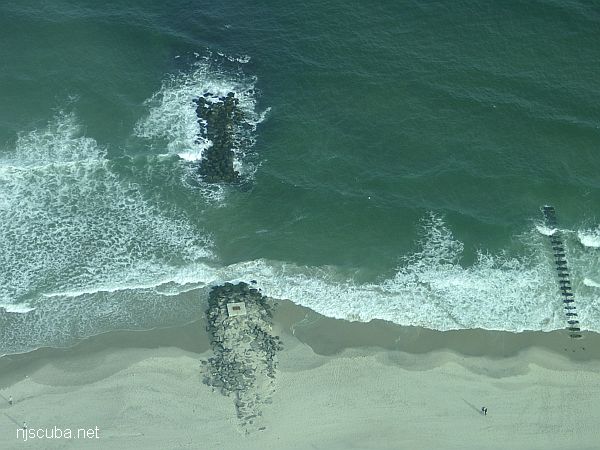
Dozens of jetties up and down the coast have been cut-though at the base like this one, making them inaccessible to fishermen, but not divers !
More: Beach Jetties ...
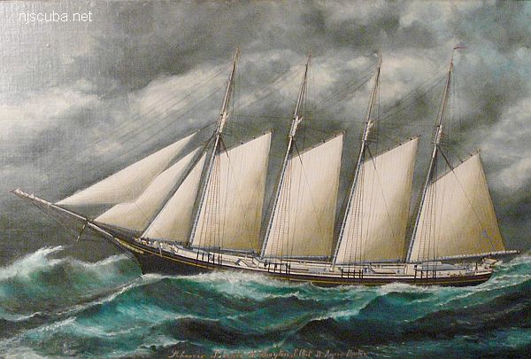
- Type:
- shipwreck, schooner, USA
- Built:
- 1891, Bath ME USA
- Specs:
- ( 201 ft ) 979 tons, 9 crew
- Sunk:
- Sunday March 27, 1914
ran aground in storm - no casualties - Depth:
- 15 ft
More: Lizzie H. Brayton ...
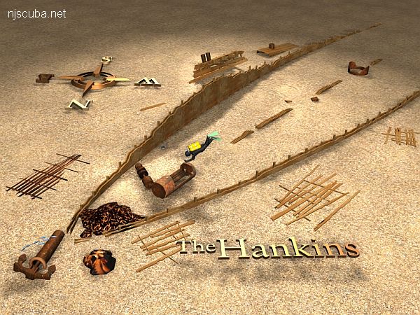
- Type:
- shipwreck, schooner barge(s)
- Sunk:
- late 1800s
- Depth:
- 80 ft
More: Hankins Wrecks ...
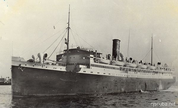
- Type:
- shipwreck, liner, USA, Clyde-Mallory Lines ( sailing under Ward Lines )
- Name:
- A tribe of Iroquoian Indians of the eastern New York area.
Three identical sisters were named Cherokee, Seminole, and Algonquin - Built:
- 1926, Newport News Shipbuilding, Newport News VA USA
- Specs:
- ( 387 x 54 ft ) 5897 gross tons, 163 passengers & crew
- Sunk:
- Thursday January 25, 1935
collision with Norwegian freighter Talisman - 45 casualties - Depth:
- 80 ft max
More: Mohawk ...