Weather Forecast
Weather Stations
44402 is a tsunami warning buoy, it doesn't do anything else.

Marine Forecasts
Forecasts issued at 9:30AM, 3:30PM, 9:30PM, 3:30AM local time.
Buoys
Buoys 44025 and 44065 now have cameras on them, although they never seem to show anything interesting.
Tides
High Tides and Tidal Differences from Sandy Hook, NJ

| Sandy Hook ( minutes ) | 0 |
|---|---|
| Navesink River ( bridge ) | +73 |
| Long Branch ( ocean ) | -26 |
| Belmar (inlet/ocean) | -30 |
| Shark River ( bay ) | -13 |
| Manasquan River ( inlet ) | -13 |
| Manasquan River ( bridges ) | -6 |
| Sea Girt ( ocean ) | -30 |
| Barnegat Inlet | current | -11 |
Always arrive early, just in case. The ocean doesn't really care what we humans predict, and tides can run early or late, especially inland, depending on the wind, weather, and other factors. Tide and current calculations are highly complex and approximate at best.
Notes
Marine forecasts especially should be taken with a grain of salt - they usually try to err on the safe side, and predict worse conditions than actually happen, but not always. At any rate, they seldom forecast more than three days in advance, usually just two.
Long-term forecasting ( say, for making reservations for next week ) is pretty much impossible, except late in the season, when you can watch the hurricanes come and go. I put a lot more stock in the real-time reports from the buoys and beach sites. It is difficult to plan anything based on this information, however. My recommendation concerning the weather and diving: make your plans anyway and hope for the best.
Marine forecasts are issued at 9:30AM, 3:30PM, 9:30PM, 3:30AM local time. I have no way of knowing, but I assume the weather service works round-the-clock in three 8-hour shifts, or something like that. Assuming this, the team that prepares the afternoon ( 3:30PM ) forecast is extremely pessimistic. The afternoon forecast is almost always worse than the one that preceded it, and the one to follow. Generally, when all is said and done, the afternoon forecast proves to be much less accurate than the rest, and I have learned to simply ignore it, and wait for the evening version. You can also make your own forecast by looking at the wind and wave time-trends on the weather buoys, something that the weather service sometimes seems to have not thought of!
Too bad the old adage about the weather forecast is still true:
Wrong too often to believe,
right too often to ignore.
Beginning divers should check out the page on Local Diving Conditions.
National Weather Service Terms
The weather service issues marine weather warnings of the following form,
based on observed or forecast winds:
| Small Craft Advisory / Small Craft Warning |
18 - 34 (knots) |
... and/or seas greater than 7 feet.Small Craft Advisories may also be issued for hazardous sea conditions or lower wind speeds that may affect small craft operations. Advisories are issued up to 12 hours in advance; Warnings are issued 24 hours in advance. Note: there is no legal definition of the term "small craft" |
| Gale Warning |
34 - 47 | Associated with a non-tropical storm. Issued up to 24 hours ahead of conditions. |
| Storm Warning |
48+ | Associated with a non-tropical storm. Issued up to 24 hours ahead of conditions. |
| Tropical Storm Warning |
34 - 63 | Associated with a tropical storm. Issued up to 24 hours ahead of conditions. |
| Hurricane Warning | 64+ | Associated with a hurricane or tropical storm. Issued up to 24 hours ahead of conditions. |
| Special Marine Warning |
34+ | Associated with a squall or thunderstorm and expected to last for 2 hours or less. Issued up to 24 hours ahead of conditions. |
Storm Warning Flags
These flags are flown at inlets, marinas, Coast Guard Stations, and other port locations to indicate hazardous weather conditions. The meaning depends on whether the flags are flown singly or in pairs.
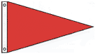 Small Craft Warning Gale Warning |  Storm Warning Hurricane Warning |
Unfortunately, there is no standardization in beach warning flags. Different colors indicate safe or hazardous surf, no swimming, no surfing, undertows, jellyfish, and other conditions, but the pattern varies from place to place.
Weather Links
- Weather.com - Belmar
- Radar
more | more
- Home ...
- Dive Sites ...
- Artificial Reefs ...
- Marine Biology ...
- Artifacts ...
- Gear & Training ...
- Blog ...
- Cozumel ...
Welcome to NJScuba.net, a website dedicated to exploring the New Jersey / New York region underwater -- "Wreck Valley". Here you will find information on dive sites, marine biology, artifacts and activities, gear and training, and many other subjects.
More: Home ...
Ocean waves are created by wind ( in unique instances, waves may also be created by earthquake, landslide, or other major disturbance, but that does not concern us here. ) The factors in the mechanics of wave creation are wind speed and duration, and fetch.
Fetch is the distance over which the wind acts on the water. The longer the fetch, the greater the wave-building action. Similarly, the greater the wind speed, the greater the wave-building action. Winds are named for the direction they blow from, not to. Therefore, a west wind blows out of the west, toward the east. Predicting wave heights based on wind conditions is even today extremely imprecise - the weather service still gets it wrong about half the time.
More: Wind, Waves & Weather ...
Diving in the Caribbean is wonderful. The weather and the viz are practically guaranteed, and the reefs will be right there where you left them last time. You can plan a whole vacation months in advance, safe in the assumption that it will almost certainly work out, or at least it won't be the weather that does you in.
If it were only like that here. Diving in New Jersey can be a very hit-and-miss proposition. There really is a lot of great diving here, but nothing in the North Atlantic is guaranteed. A week's worth of bad weather, or a month, or a whole summer of sunshine and glass seas, there's just no telling.
More: Local Diving Conditions ...