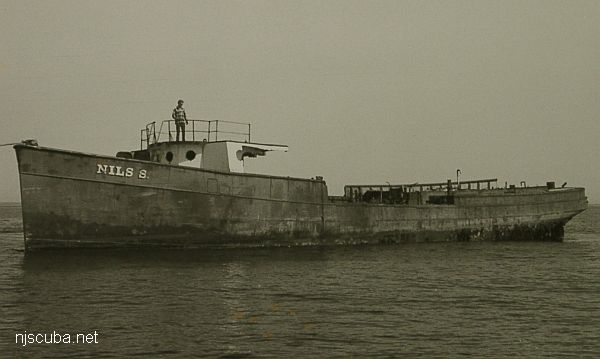
u03 - AWOIS 1609

NM22/46 -- DERRICK BARGE WRECK LIGHTED BUOY 3, BLACK, QK FL GREEN, ESTABLISHED IN 62 FT., 1.75 MILES, 63 DEG. FROM SCOTLAND LIGHT VESSEL. BUOY LOCATED 200 FEET EAST OF SUNKEN WRECK WHICH LIES IN A SE-NW DIRECTION.

H10224/86 -- OPR-C121-WH-86; MAIN SCHEME HYDROGRAPHY AND SIDE-SCAN SONAR INVESTIGATION REVEALED WHAT APPEARED TO BE A WRECK IN FOUR PIECES 447M SW OF WRECK; FOUR DIVES WERE PERFORMED IN 1987; FOUND A BARGE, APPROXIMATELY 50 X 120 FT WITH A PNEUMATIC DEPTH GAUGE LEAST DEPTH OF 63 FT; 0-5 FT VISIBILITY; A STRUCTURE SIMILAR TO A DERRICK CRANE WAS FOUND; HYDROGRAPHER AND EVALUATOR RECOMMENDED DELETING CHARTED SYMBOL AND ADDING 63 WK AS SHOWN ON PRESENT SURVEY. (UPDATED MSD 4/91)

24 NO. 1350; BARGE, SUNK 5/30/46; POS. ACCURACY WITHIN 1 MILE;


Comments on u03 - AWOIS 1609

Questions or Inquiries?

Just want to say Hello? Sign the .

Submit a Comment

Your email address will not be published. Required fields are marked *


Click image to replace if unable to read.

Enter the digits from the image above, except for the last one:

This site uses Akismet to reduce spam. Learn how your comment data is processed.


Shark River - A Street
View of the up-river area, looking southeast. Either side is diveable upstream to the first road. The entry location is just to the right of the apartments.

Yet another place to dive the Shark River is on the south side, near the intersection of 1st Avenue and A Street, behind the apartments. There is limited but very convenient free parking. A small cement stairway leads down to a concrete ledge above the water. Climb down between the big rock and the bulkhead, where you will find more steps underwater. ( Whoever B.M and M.M. are - thank you! )

Printed from njscuba.net