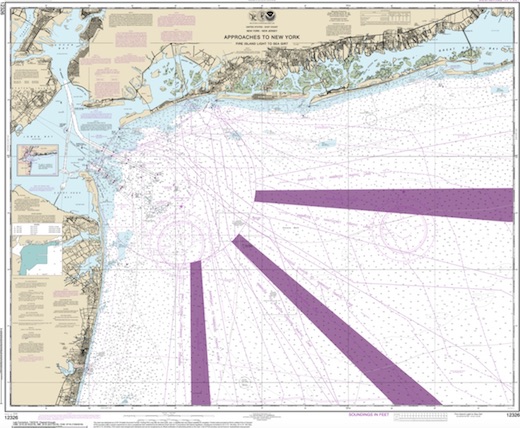
Rockaway Dive Sites Chart
- Across Wreck
- Alexander Hamilton
- Allenhurst Jetty
- Arnoff
- Arundo
- Asfalto
- Atlantic Beach Reef ...
- Aurora
- Ayuruoca
- BA Wreck
- Balaena
- Bald Eagle
- BD 1738
- Beach Jetties
- Benson
- Black Warrior
- Bronx Queen
- Cecilia M. Dunlap
- Charles Dunlap
- Chauncey Jerome
- Choapa
- Continent
- Cornelia Soule
- Cornelius Grinnell
- crane barge
- Daghestan
- Delaware Water Gap
- drydock barge
- Dryland
- Dual Wrecks
- Dutch Springs (Lake Hydra) ...
- Edmund Phinney
- Elberon Rocks
- Eureka
- Fort Victoria
- G.L. 78
- German
- Glen II
- Goulandris
- Gypsy
- H.W. Long
- HMS Pentland Firth
- Hudson/East Rivers
- Iberia
- Immaculata
- Jack-I
- Larsen
- Lido (Coal Wreck)
- Lizzie D
- Locomotives
- Long Branch Pier
- Macedonia
- Malta
- McAllister Reef ...
- Mistletoe
- Mud Hole
- Nautilus
- Navesink River
- New Deal
- New Era
- New Jersey Aquarium
- Pinta
- Pipe Barge
- Pliny
- Plymouth
- Pocopson
- Princess Anne
- R.C. Mohawk
- Ramos
- Raritan Bay
- Raritan River
- Relief Lightship
- Rickseckers
- Robert A Snow
- Rockaway Reef ...
- Round Valley
- Rudder Wreck
- Ruth Shaw
- Sandy Hook
- Sandy Hook Pilot
- Sandy Hook Reef ...
- SC-60
- Scotland
- Shark River
- Shark River - A Street
- Shark River - Back Bay
- Shark River Inlet
- Shrewsbury Rocks
- Steel Wreck
- Sylvanus
- Tampa III
- Three Sisters
- Triangle Wrecks
- u01 - AWOIS 8087
- u02 - AWOIS 12966/11422
- u03 - AWOIS 1609
- u04 - AWOIS 8084
- u05 - AWOIS 7940
- u06 - AWOIS 7938
- u07 - AWOIS 8076
- u08 - AWOIS 4600
- u09 - AWOIS 8075
- u10 - AWOIS 8097
- u11
- u12 - AWOIS 7509
- u13 - AWOIS 7932
- u14 - AWOIS 9768
- USS Turner
- Valerie E
- Vega
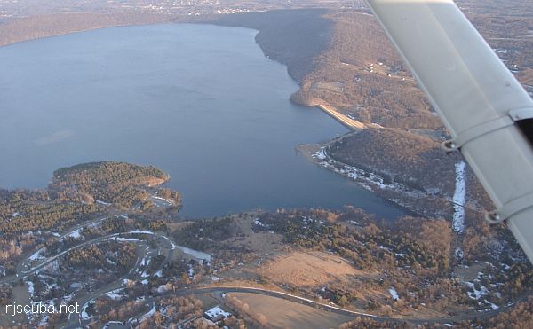
- Type:
- freshwater artificial reservoir
- Depth:
180 ft , but less than 60 ft in the usual area
More: Round Valley ...
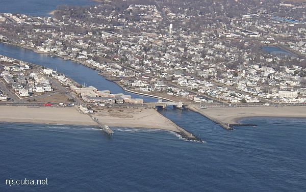
- Type:
- smallish tidal river inlet with stone jetties or bulkheads on both sides
- Depth:
- 15 ft
This inlet has an L-shaped jetty on the north side and a longer straight jetty on the south side. Both jetties are made of loose stones - hardly any concrete - and the bottom is sandy and usually clean. You can walk over the bridge from one side of the inlet to the other in about five minutes.
More: Shark River Inlet ...
- Type:
- shipwreck, barge
- Sunk:
- March 2004
foundered under tow - Depth:
- 60 ft
This medium-sized crane barge sank under tow in March 2004. The barge is upside-down, but propped up at a 30-degree angle by the crane, rising 30 feet off the bottom at the highest point. The crane is a large rotating affair that is permanently mounted on the barge. It is not the crumpled arm of the crane that supports the hull, but the central cab, so the wreck is stable, and it is safe to explore the cavernous dark space below. The bottom is coarse sand and pea gravel. Eventually, the wreck will crush flat, but that will probably take several years, and until then this is a fun and interesting site. Big eels, Sea Bass, and even one or two lobsters can be found here.
More: crane barge ...
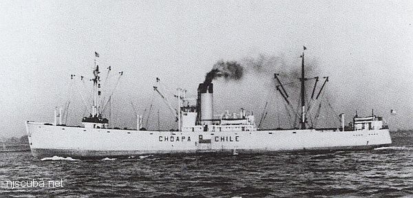
- Type:
- shipwreck, freighter, Chile
- Built:
- 1937, England, as Helga
- Specs:
- ( 292 x 41 ft ) 1700 gross tons, 67 crew
- Sunk:
- Thursday September 21, 1944
collision with tanker British Harmony, then with freighter Voco ( 5090 tons) while at anchor, then with tanker Empire Garrick - no casualties - Depth:
- 195 ft, starts at 160 ft
More: Choapa ...