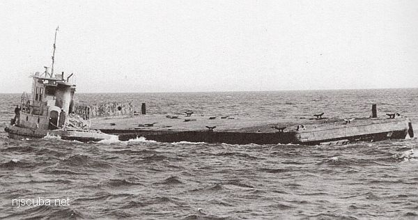
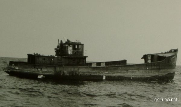
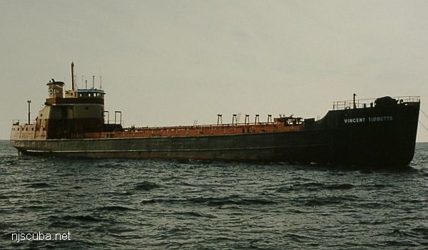
Artificial Reef Sites (26/26)

Susan Rose Sunk in February

The Susan Rose was re-sunk as an artificial reef in February. At present there still has been no public announcement. Here is the NJDEP contact form if you would like to inquire:

If you would like to visit this or any other of New Jersey's new unpublished reefs, contact New Jersey Artificial Reef Coordinator Peter Clarke at Mad Hatter Charters in Neptune City.

Artificial Reefs

The pink and white areas are shipping lanes. 'Natural' shipwrecks are depicted with a wreck symbol.

 1  24 25 26  

Winthrop reef
Type:
artificial reef, trawler, USA
Built:
1948, Bath Iron Works, Maine, USA
Specs:
( 117 x 24 ft ) 195 gross tons
Sponsor:
Eirek's Dock, Fish America Foundation
Sunk:
Wednesday July 12, 1989 - Cape May Artificial Reef
GPS:
38°50.825' -74°43.312'
Depth:
60 ft

Type:
artificial reef, clam dredge, USA
Built:
1936, Humphreys Railways, Weems VA, as Aspen
Specs:
( 100 x 18 ft )
Sponsor:
Wyoming Boat Corp, Cape May County Party & Charter Boat Association
Sunk:
Saturday Dec 7, 1991 - Cape May Artificial Reef
GPS:
38°52.976' -74°40.620'

no photo available

Type:
artificial reef, barge
Built:
1953, New Orleans LA, as BCL-1103
Specs:
( 110 x 34 ft ) 144 tons
Sunk:
Friday Oct 20, 2000 - Delaware #11 Artificial Reef
GPS:
38°40.540' -74°43.957'

Type:
artificial reef, barge, US Navy
Built:
1941, Dravo Corp, Wilmington DE USA
Specs:
( 110 x 35 ft ) 400 tons dead weight
Sunk:
Wednesday March 10, 2010 - Delaware #10 Artificial Reef
GPS:
38°36.608' -74°56.494'


John Dobilas reef
Type:
artificial reef, tanker
Specs:
( 165 x 35 ft )
Sponsor:
Friends of John Dobilas & the McGraw Hill Foundation
Sunk:
Tuesday August 20, 1996 - Garden State North Artificial Reef
GPS:
39°37.564' -74°01.341'
Depth:
80 ft

Ocean Wreck Divers III reef
Type:
artificial reef, barge, US Navy
Built:
1942
Specs:
( 174 x 40 ft ) 200 tons light
Sunk:
Tuesday June 18, 2002 - Delaware #10 Artificial Reef
GPS:
38°36.424' -74°56.498'

Type:
artificial reef, ferry, converted WWII Navy patrol boat, USA
Built:
Specs:
( 63 ft )
Sunk:
Friday May 10, 1985 - Fire Island Artificial Reef
Depth:
75 ft
GPS:
40°35.587' -73°11.221'

Artificial Reef Sites

 1  24 25 26  

H10224/86 -- OPR-C121-WH-86; WHILE INVESTIGATING ITEM 751, AN AREA WITH NUMEROUS SIDE-SCAN SONAR CONTACT WAS FOUND AND DEVELOPED USING SIDE-SCAN AND ECHO SOUNDER; DIVER INVESTIGATION DETERMINED LIMITS OF SITE, NATURE OF WRECKAGE, AND LOCATION OF THE LEAST DEPTH; SITE WAS ORIENTED NORTHEAST-SOUTHWEST; CONSISTS MOSTLY OF SHIPYARD DEBRIS IN THE FORM OF HEAT EXCHANGERS, BUCKLED DECK PLATING, TWISTED ANGLE IRON, WOODEN RIBS, AND PIPING OF VARIOUS LENGTHS AND SIZES; THE NORTHEAST END OF THE SITE CONSISTED OF A BARGE LYING IN A NORTHWEST-SOUTHEAST DIRECTION WITH THE BOW OF THE BARGE DEFINING THE SOUTHEAST WALL OF THE SITE; THE NORTHWEST END OF THE BARGE, THE STERN, WAS COVERED WITH METAL DEBRIS, HAWSER LINES, AND TRAWLER NETTING; DIVERS CONCLUDED THAT THIS SITE IS THE WRECK OF A BARGE THAT WAS FILLED WITH SHIPYARD SCRAP IRON AND DEBRIS; PNEUMATIC DEPTH GAUGE LEAST DEPTH OF 50 FT. (ENTERED MSD 4/91)

Printed from njscuba.net