New York Dive Sites
Dive Sites - New York
- 3/4 Tug
- 59-Pounder
- Acara
- Ajace
- Amsterdam
- Andrea Doria
- Arnoff
- Asfalto
- Atlantic
- Atlantic Beach Reef ...
- Ayuruoca
- BA Wreck
- Bald Eagle
- Barataria
- Bayville barge
- Beach Jetties
- Black Point
- Black Warrior
- Bronx Queen
- Bug Light
- Burnside
- Celtic / Cape Race
- Charles Dunlap
- Choapa
- Coastwise
- Coimbra
- Condor
- Continent
- Cornelia Soule
- Defender
- Dodger
- Dragger
- Drumelzier
- drydock barge
- E. Rockaway Inlet / 8th St
- Ed's Schooner
- Edwin Duke
- Essex
- Eureka
- Fire Island Inlet
- Fire Island Reef ...
- Fort Victoria
- Gate City
- Glen Island
- Gluckauf
- Goulandris
- Grecian
- Gwendoline Steers
- Happy Days
- Harvey's Schooner
- Hempstead Reef ...
- HMS Culloden
- HMS Hussar
- Horton's Point
- Howard
- Hudson/East Rivers
- Huntington Reef
- Hylton Castle
- Iberia
- Immaculata
- Inshore Schooner
- Irma C
- John A. Downs
- John C. Fitzpatrick
- Jones Inlet / Wreck
- Kenosha
- Kismet Reef ...
- Larchmont
- Lexington
- Lido (Coal Wreck)
- Lightburne
- Linda
- Lizzie D
- Macedonia
- Maine
- Malden
- Margaret
- Matinecock Reef ...
- Mattituck Inlet
- Mattituck Reef ...
- McAllister Reef ...
- Mistletoe
- Montauk Inlet
- Moriches Inlet
- Moriches Reef ...
- Mount Sinai Harbor
- Mud Hole
- Myronus
- NY Artificial Reefs ...
- Olinda
- Oregon
- Panther
- Pinta
- Pipe Barge
- Poling Brothers #2
- Ponquogue Bridge
- Port Jefferson Inlet
- Port Jefferson Reef ...
- Princess Anne
- R.C. Mohawk
- Reggie
- Relief Lightship
- Rickseckers
- Robert A Snow
- Rockaway Inlet
- Rockaway Reef ...
- Roda
- Ruth Shaw
- Sandy Hook Pilot
- Seawolf
- Shinnecock Inlet
- Shinnecock Reef ...
- Shoreham
- Sixteen Fathom Reef
- Smithtown Reef ...
- Snug Harbor
- Steel Wreck
- Tennyson
- Texas Tower
- Thames
- Thelma Phoebe
- Three Sisters
- Train Wheel Wreck
- Twelve-Mile Reef ...
- U-853
- U-869
- USS Bass
- USS G-1 SS-19
- USS G-2 SS-27
- USS L-8 SS-48
- USS Ohio
- USS San Diego
- USS Tarantula
- USS Turner
- Valerie E
- Volund
- Wolcott
- Yankee (G&D)
- Yankee (Old)
- Yellowbar Reef ...
- Type:
- shipwreck, schooner
- Sunk:
- circa 1860; cause unknown
- Depth:
- 35 ft
low wood debris field, bottles, coconut shells
More: Inshore Schooner ...
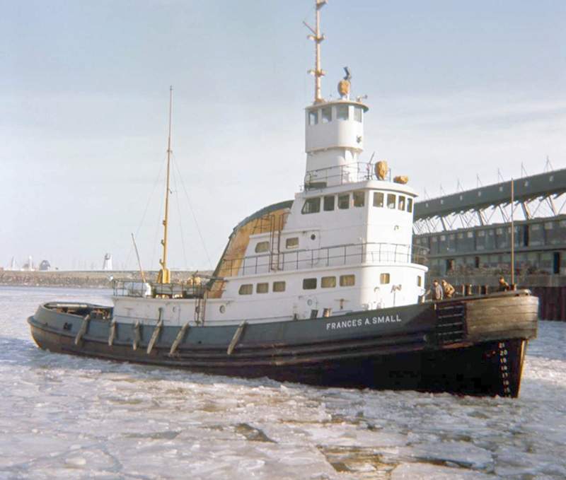
- Type:
- shipwreck, tugboat, USA
- Type:
- Fraser Shipyards, Superior, WI as Frances A. Small
- Specs:
- ( 113 x 31 ft, 850 tons ) 8 crew
- Sunk:
- Sunday March 3, 1985
collision with one of its own barges - no casualties - Depth:
- 230 ft
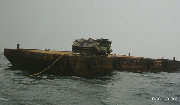
More: John A. Downs ...
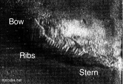
- Depth:
- 110 ft
This unidentified wood wreck sits in 110 feet of water 17 miles out of Fire Island Inlet. The wreck was found by Captain Jay Porter the wreck was apparently named for the weight of a large codfish caught on the site. The wreck's wooden ribs only protrude a foot or so out of the sand but divers report that the site is excellent for catching large lobsters. A few years ago Captain Billy DeMarigny found the ship's bell. Unfortunately, no name was on it.
More: 59-Pounder ...
- Type:
- shipwreck, tugboat, USA
- Built:
- 1937, Bethlehem Beaumont, Beaumont TX USA
- Specs:
- ( 68 ft ) 4 crew
- Sunk:
- Tuesday November 25, 1971
structural failure during storm due to improper modifications - 2 casualties - Depth:
- 136 ft
More: Barataria ...
Moriches Artificial Reef (historical)
2.4 nautical miles south of Moriches Inlet, 0.54 sq miles
Depth: 70 - 75 ft
More: Moriches Artificial Reef ...