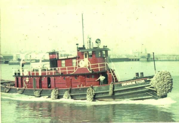
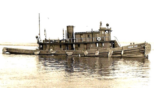
Gwendoline Steers

Type:
shipwreck, tugboat, USA
Built:
1888, camden NJ USA, as Douglas H. Thomas
Specs:
( 97 x 21 ft ) 148 tons, 9 crew
Sunk:
Sunday December 30, 1962
cause unknown - no survivors
Depth:
40 ft, starts at 20 ft

The Gwendoline Steers was used to haul gravel from a huge gravel pit in Northport to NYC. The loss of the Gwendoline Steers may have been due to icing in a blizzard, or age and poor maintenance. A week earlier she had been run aground. The wreck sits intact and upright, with usually poor visibility.

Shipwreck Gwendoline Steers

Comments on Gwendoline Steers

Questions or Inquiries?

Just want to say Hello? Sign the .

Submit a Comment

Your email address will not be published. Required fields are marked *


Click image to replace if unable to read.

Enter the digits from the image above, except for the last one:

This site uses Akismet to reduce spam. Learn how your comment data is processed.


from AWOIS: 1607

NM47/66 -- DANGEROUS WRECK OF DREDGE DRYLAND, 62 FT. LONG. 22 FT. WIDE REPORTED SUNK IN ABOUT 90 FT. COVERED ABOUT 55 FT.

CL1540/78 -- MAR, OPR-C622-RU/HE-78; ITEM 4; INVESTIGATION BEGAN 30 AUGUST AND WAS COMPLETED ON 18 SEPTEMBER. EFFECTIVELY CLEARED TO MIN. OF 45.5 FT., (38.5 FT. ON A 40 FT. SHOAL), WITH NO HANGS ENCOUNTERED.

FE221/78-79 -- OPR-C622-RU/HE; ITEM 4; REQUIRED CLEARANCE TO 45 FT. DUE TO POSSIBLE HAZARDS ON THE BOTTOM. 1 MILE, RADIUS CIRCLE DRAGGED TO 45 FT. EXCEPT TO 38 FT. ON 40 FT. SHOAL (SEE AWOIS NO.00752) NW OF AMBROSE LIGHT TOWER. NO HANGS ENCOUNTERED. RECOMMENDED THAT CLEARED AREA BE CHARTED WITH GREEN TINT WITH 45 FT. CLEARANCE NOTE WHERE APPROPRIATE.

H10224/86-87 -- OPR-C121-WH-86-87; WRECK FOUND DURING MAIN SCHEME HYDROGRAPHY AND SIDE-SCAN SONAR OPERATION 850M EAST OF REPORTED POSITION; SIX DIVES PERFORMED; 2-15 FT VISIBILITY; PNEUMATIC DEPTH GAUGE LEAST DEPTH OF 86 FT TAKEN ON TOP OF A 20 FT LONG DREDGE PIPE FLOAT FOUND 841.6M EAST OF AWOIS POSITION; WRECK SITE REVEALED PIPES, FLOATS, AND DREDGING EQUIPMENT. (UPDATED MSD 4/91)

Printed from njscuba.net