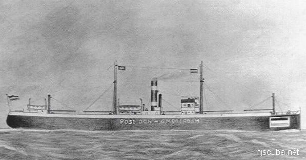
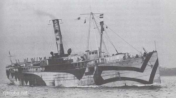
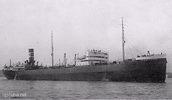
New Jersey Dive Sites (21/31)

Dive Sites - New Jersey

 Page 1  20 21 22  31  

Shipwreck Pinta
Type:
shipwreck, freighter, Netherlands
Name:
The Pinta was one of three sister ships named for Columbus' original three vessels, the Nina, the Pinta, and the Santa Maria.
Built:
1959, Denmark
Specs:
( 194 x 31 ft ) 1000 gross tons, 12 crew
Sunk:
Wednesday May 8, 1963
collision with freighter City of Perth ( 7547 tons) - no casualties
GPS:
40°13.827' -73°50.625' (AWOIS 1988)
Depth:
85 ft, starts at 55 ft


Shipwreck Pliny
Type:
shipwreck, steamer, England
Built:
1878, England
Specs:
( 288 x 33 ft ) 1671 gross tons, 55 passengers & crew
Sunk:
Saturday May 13, 1882
ran aground - no casualties
Depth:
25 ft

Type:
shipwreck, schooner barge
Built:
1916, Elkton MD USA
Specs:
( 199 x 24 ft ) 474 tons
Sunk:
Monday March 31, 1924
foundered in storm, 5 casualties ( see Pocono )
Depth:
65 ft

Shipwreck Pocopson
Mr. Eliassen is reasonably sure that this image is of the Pocopson, on which he sailed as a child when his father was Captain, 1922-1925.
Type:
shipwreck, schooner barge, USA
Built:
1906, Robert Palmer & Son, Noank CT, USA
Specs:
( 177 x 35 ft ) 721 tons, 3 crew
Sunk:
Wednesday October 7, 1936
foundered in storm, no casualties
GPS:
40°12.204' -73°59.257' (AWOIS 1990)
Depth:
50 ft

Shipwreck Poseidon
Type:
shipwreck, iron-hulled screw freighter, USA
Built:
1914, Scotland
Specs:
( 295 x 43 ft ) 1909 tons
Sunk:
Wednesday July 31, 1918
collision with freighter SS Somerset
Depth:
90 ft


Shipwreck R.C. Mohawk
Not to be confused with the S.S. Mohawk or the other S.S. Mohawk.
Type:
shipwreck, revenue cutter, U.S. Revenue Service, on loan to U.S. Navy
Name:
A tribe of Iroquoian Indians of the eastern New York area.
Built:
1902, William R. Trigg, Richmond VA USA
Specs:
( 206 x 32 ft ) 980 gross tons, 77 crew
Sunk:
Monday October 1, 1917
collision with tanker Vennachar - no casualties
GPS:
40°25.025' -73°45.158' (AWOIS 2010)
Depth:
100 ft

Railroad Bridge
Viewed from the northwest, prior to reconstruction, winter, high tide. 7-11 store at upper right.
Type:
inland tidal river
Depth:
20 ft, mostly a lot shallower

This spot is upstream on the Manasquan River. The diving area is rather small and not very deep. Visibility tends to be poor, and this is worsened whenever an O/W training class is in session, which is often. Also, the current under the bridge becomes very strong, so slack water is essential. For a long time, a dredge barge has been anchored in the channel, but otherwise, there is no boat traffic.


Type:
shipwreck, schooner barge
Specs:
1208 tons
Sunk:
Friday June 30, 1933
GPS:
40°25.505' -73°54.071' (AWOIS 1990)
Depth:
80 ft

Nearby are the remains of several other barges.


from AWOIS:

H10224/86 -- OPR-C121-WH-86; WRECKAGE WITH 52 FT PNEUMATIC DEPTH GAUGE LEAST DEPTH, WHICH IS BELIEVED TO BE THIS ITEM, APPROXIMATELY 100M SW OF AWOIS POSITION; DIVERS FOUND THE WRECK OF A BARGE, APPROXIMATELY 20 X 45 M; THREE BOILERS AND NUMEROUS OTHER TYPES OF SHIPYARD DEBRIS WERE FOUND STREWN OVER AN AREA OF 360 X 165 FT; IN THE NW CORNER OF THE SITE THE REMAINS OF ANOTHER WRECK WAS FOUND WITH ONLY THE SHELL PLATING AND FLOOR FRAMING REMAINING; APPROXIMATELY 200 FT LONG, 27 FT BEAM AND SHELL PLATING EXTENDING 5 FT ABOVE THE BOTTOM; BOTH ENDS OF THE WRECK TAPERED INTO THE SAND WITH NO BOW OR STERN VISIBLE; ONE OBJECT CONSISTING OF GUARD RAIL TYPE METAL, APPROXIMATELY 2 FT WIDE, 3/8 INCH THICK, AND 40 FT LONG, FORMING A 60 DEGREE ARCH WITH THE MIDDLE STANDING 10 FT OFF THE BOTTOM; SITE CONSISTED OF TWO WRECKS AND SHIPYARD DEBRIS, INCLUDING A BOOM CRANE; LEAST DEPTH TAKEN ON THE TOP OF THE BOILER LOCATED AT THE NORTHEAST SECTION OF SITE. (UPDATED MSD 4/91)

Printed from njscuba.net