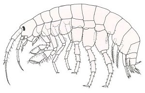
World War I (3/3)

 1 2 3  

Shipwreck USS San Diego
USS San Diego photographed 28 January 1915, while serving as flagship of the Pacific Fleet. Her name had been changed from California on 1 September 1914. Note two-star Rear Admiral's flag flying from her mainmast top.
Type:
shipwreck, armored cruiser, U.S. Navy
Built:
1904, San Francisco USA, as U.S.S. California
Specs:
( 503 x 70 ft ) 13680 displacement tons
Sunk:
Friday July 19, 1918
explosion, probably struck a mine laid by U-156
officially 6 casualties, probably 30-40 in reality
GPS:
40°32.433' -73°02.484' (AWOIS 2008)
Depth:
110 ft, starts at 65 ft

Shipwreck USS Tarantula
Type:
shipwreck, patrol boat, converted yacht, U.S. Navy
Built:
1912, Neponset MA USA
Specs:
( 129 x 19 ft ) 160 gross tons
Sunk:
Monday October 28, 1918
collision with steamer Frisia - no casualties
Depth:
115 ft

Shipwreck Winneconne
Type:
shipwreck, freighter, USA
Name:
Named for a town in eastern Wisconsin?
Built:
1907, England, as Hogland
Specs:
( 271 x 39 ft ) 1869 gross tons
Sunk:
Sunday June 2, 1918
bombed by U-151 - no casualties
Depth:
220 ft

World War I

 1 2 3  

Aids to Navigation

sea lanes

The US Coast Guard maintains a number of aids to navigation to assist vessels entering and leaving ports, both great ports like New York and Philadelphia, and minor ports like Shark River and Montauk. At sea, these aids take the form of buoys that mark out channels and shipping lanes.

Shipping lanes are like divided highways at sea. Inbound and outbound lanes are separated by a wide "Separation Zone, " which may or may not be depicted on the charts in this website, depending on the scale. Ships "drive on the right" just like cars in civilized countries. At the inbound end where all the lanes converge into the harbor channel, things get messy, and I didn't try to depict it. Likewise, the outer ends of the lanes are not exact either.

Printed from njscuba.net