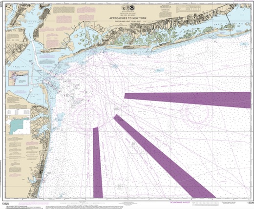
Sandy Hook Dive Sites Chart
Sandy Hook / Rockaway Inlet Chart
- Barge #10
- 120 Wreck
- 3 Sisters
- Ambrose Buoy
- A Street - Shark River
- Acara
- Across
- Adele
- Ajace
- Alex Mac
- Allenhurst Jetty
- Antioch
- Arnoff
- Arundo
- Asfalto
- Aurora
- Ayuruoca
- BA Wreck
- Shark River - Back Bay
- Balaena
- Bald Eagle
- BD1738
- USS Benson
- Beth Dee Bob
- Blue Boy
- Bronx Queen
- Bug Light
- Charles Dunlap
- Cecilia M Dunlap
- Catherine Jackson
- Chauncy Jerome
- Cornelia Soule
- Choapa
- coal (Lido)
- Continent
- crane barge
- Daghestan
- Dragger
- drydock
- Dryland
- Edwin Duke / Stone Barge
- dump
- Dutch Springs
- Edmund Phinney
- East Rockaway Inlet
- Ed's Schooner
- Elberon Rocks
- Eureka
- Finance
- Fort Victoria
- German
- GL78
- Glen II
- I.P. Goulandris
- Gypsy
- Horseshoe Cove
- Alexander Hamilton
- Howard
- Iberia
- Immaculata
- Inshore Schooner
- Jack I
- Joan La Rie III
- Jones Inlet
- Jones Tug
- Klondike Rocks
- Larsen
- Lizzie D
- Long Branch locomotives
- Logwood
- H.W. Long
- Macedonia
- Mahogany
- Malta
- Manasquan Inlet
- Margaret
- Marion
- Mistletoe
- R.C. Mohawk
- Manasquan Wreck
- Nautilus
- Navesink River
- Northeast Sailor
- New Reef
- New Deal
- New Era
- HMS Pentland Firth
- Long Branch Pier Rubble
- Pinta
- Pipe Barge
- Pliny
- Plymouth
- Pocopson
- Princess Anne
- Ruth Shaw
- Robert A Snow
- Ramos
- Ranger
- Relief Lightship
- Rickseckers
- Rjukan
- Rockaway Inlet
- Rockaway Belle
- Round Valley
- Roy's barge
- Rudder Wreck - Pocono
- Rusland / Adonis
- Scotland Buoy
- Sandy Hook Pilot Boat
- SC-60
- Sea Girt Inlet
- Sea Girt Wreck
- Shark River Inlet
- Shrewsbury Rocks
- Spring Lake Sailor
- Steel Wreck
- Stolt Dagali
- Sylvanus
- Tampa III
- USS Turner
- AWOIS 8087
- AWOIS 8097
- u11
- AWOIS 7509
- AWOIS 7932
- AWOIS 9768
- AWOIS 12966/11422
- AWOIS 1609
- AWOIS 8084
- AWOIS 7940
- AWOIS 7938
- AWOIS 8076
- AWOIS 4600
- AWOIS 8075
- Valerie E
- Vega
- Warrior
- Delaware River Water Gap
- Western World
- Edward W Winslow
- Across Wreck
- Alexander Hamilton
- Allenhurst Jetty
- Arnoff
- Arundo
- Asfalto
- Atlantic Beach Reef ...
- Aurora
- Ayuruoca
- BA Wreck
- Balaena
- Bald Eagle
- BD 1738
- Beach Jetties
- Benson
- Black Warrior
- Bronx Queen
- Cecilia M. Dunlap
- Charles Dunlap
- Chauncey Jerome
- Choapa
- Continent
- Cornelia Soule
- Cornelius Grinnell
- crane barge
- Daghestan
- Delaware Water Gap
- drydock barge
- Dryland
- Dual Wrecks
- Dutch Springs (Lake Hydra) ...
- Edmund Phinney
- Elberon Rocks
- Eureka
- Fort Victoria
- G.L. 78
- German
- Glen II
- Goulandris
- Gypsy
- H.W. Long
- Hudson/East Rivers
- Iberia
- Immaculata
- Jack-I
- Larsen
- Lido (Coal Wreck)
- Lizzie D
- Locomotives
- Long Branch Pier
- Macedonia
- Malta
- McAllister Reef ...
- Mistletoe
- Mud Hole
- Nautilus
- Navesink River
- New Deal
- New Era
- New Jersey Aquarium
- Pentland Firth
- Pinta
- Pipe Barge
- Pliny
- Plymouth
- Pocopson
- Princess Anne
- R.C. Mohawk
- Ramos
- Raritan Bay
- Raritan River
- Relief Lightship
- Rickseckers
- Robert A Snow
- Rockaway Reef ...
- Round Valley
- Rudder Wreck
- Ruth Shaw
- Sandy Hook
- Sandy Hook Pilot
- Sandy Hook Reef ...
- SC-60
- Scotland
- Shark River
- Shark River - A Street
- Shark River - Back Bay
- Shark River Inlet
- Shrewsbury Rocks
- Steel Wreck
- Sylvanus
- Tampa III
- Three Sisters
- Triangle Wrecks
- u01 - AWOIS 8087
- u02 - AWOIS 12966/11422
- u03 - AWOIS 1609
- u04 - AWOIS 8084
- u05 - AWOIS 7940
- u06 - AWOIS 7938
- u07 - AWOIS 8076
- u08 - AWOIS 4600
- u09 - AWOIS 8075
- u10 - AWOIS 8097
- u11
- u12 - AWOIS 7509
- u13 - AWOIS 7932
- u14 - AWOIS 9768
- USS Turner
- Valerie E
- Vega
- Type:
- shipwreck, submarine chaser, U.S. Navy
- Built:
- 1917, New York Naval Shipyard, New York NY USA
- Specs:
- ( 110 x 14 ft ) 85 tons
- Sunk:
- Tuesday October 1, 1918
collision with tanker Fred W. Waller - 2 casualties - Depth:
- 45 ft
More: Sub Chaser SC-60 ...
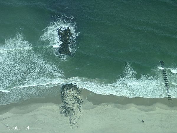
Dozens of jetties up and down the coast have been cut-though at the base like this one, making them inaccessible to fishermen, but not divers !
More: Beach Jetties ...
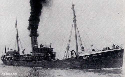
- Type:
- shipwreck, trawler, Royal Navy
- Name:
- Pentland Firth is the channel between the northern tip of Scotland and the Islands that form Scapa Flow, the great British naval base, and today one of the best wreck diving locales in the world.
- Built:
- 1934, England
- Specs:
- ( 164 x 27 ft ) 485 gross tons
- Sunk:
- Saturday September 19, 1942
collision with minesweeper trawler USS Chaffinch (400 tons) - ? casualties - GPS:
- 40°25.433' -73°52.204' (AWOIS 1991)
- Depth:
- 70 ft
More: HMS Pentland Firth ...
Note the locomotives on deck, foreward of the aft mast.
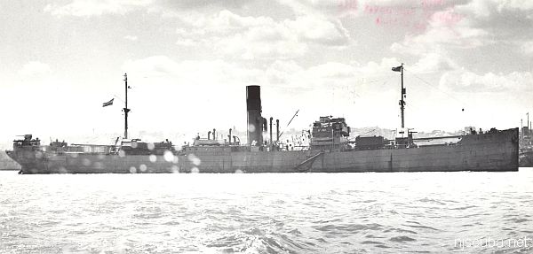
- Type:
- shipwreck, freighter, Netherlands
- Built:
- 1930, New Castle England, as Petersfield
- Specs:
- ( 412 x 55 ft ) 5163 gross tons, 43 crew
- Sunk:
- Tuesday April 28, 1942
torpedoed by U-136 - 6 casualties - Depth:
- 140 ft max; 110 ft min; 125 ft typical
More: Arundo ...
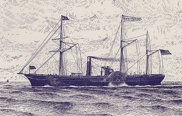
- Type:
- shipwreck, steamer, USA
- Built:
- 1852, Thomas & William Collyer, New York NY USA
- Specs:
- ( 225 x 37 ft ) 1556 gross tons
- Sunk:
- Sunday February 20, 1859
ran aground in fog - no casualties - GPS:
- 40°25.641' -73°51.135' (AWOIS 2003)
- Depth:
- 35 ft
More: Black Warrior ...
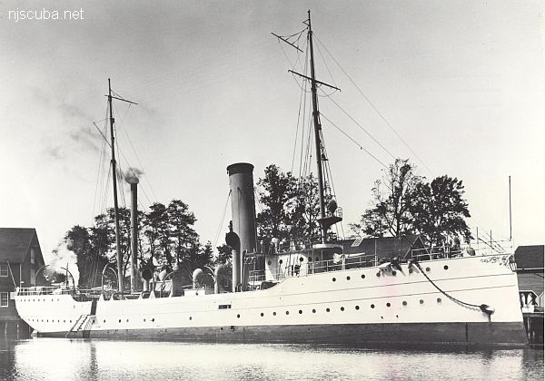
- Type:
- shipwreck, revenue cutter, U.S. Revenue Service, on loan to U.S. Navy
- Name:
- A tribe of Iroquoian Indians of the eastern New York area.
- Built:
- 1902, William R. Trigg, Richmond VA USA
- Specs:
- ( 206 x 32 ft ) 980 gross tons, 77 crew
- Sunk:
- Monday October 1, 1917
collision with tanker Vennachar - no casualties - GPS:
- 40°25.025' -73°45.158' (AWOIS 2010)
- Depth:
- 100 ft
More: R.C. Mohawk ...