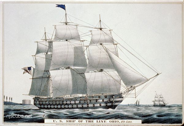
USS Ohio
- Type:
- shipwreck, 74 gun ship-of-the-line, U.S. Navy
- Name:
- that place next to Indiana
- Built:
- 1820, New York Naval Shipyard, Brooklyn NY USA
- Specs:
- ( 208 x 54 ft ) 2757 gross tons
- Sunk:
- April 1884
set adrift and grounded by storm while being dismantled, later deliberately burned - Depth:
- 20 ft
The stripped hulk of the Ohio eventually burned and sank. Today nothing is left but scattered timbers and debris.
USS Ohio
Dive Sites, Long Island Sound Dive Sites, New York Dive Sites, Sailing Ships, Warships,
Long Island Sound - West Chart
- Amsterdam
- Atlantic
- Barataria
- USS Bass
- Bayville barge
- Black Point
- Celtic/Cape Race
- Condor
- HMS Culloden
- Defender
- John A. Downs
- Essex
- Gwendoline Steers
- USS G-1
- USS G-2
- Grecian
- Horton's Point / Commodore
- Huntington Artificial Reef
- HMS Hussar
- USS L-8
- Larchmont
- Lexington
- Lightburne
- Malden
- Matinecock Artificial Reef
- Mattituck Inlet
- Mattituck Artificial Reef
- Montauk Inlet
- Mount Sinai Harbor
- Myronus
- USS Ohio
- Olinda
- Pinnacle
- Poling Bros #2
- Port Jefferson Artificial Reef
- Port Jefferson Inlet
- Puszta
- Shoreham Nuclear Power Plant
- Smithtown Artificial Reef
- Snug Harbor
- Thames
- Thelma Phoebe
- U-853
- Volund
- Delaware River Water Gap
- Block Island Wind Farm
Long Island Sound - East Chart
- Amsterdam
- Atlantic
- Barataria
- USS Bass
- Bayville barge
- Black Point
- Celtic/Cape Race
- Condor
- HMS Culloden
- Defender
- John A. Downs
- Essex
- Gwendoline Steers
- USS G-1
- USS G-2
- Grecian
- Horton's Point / Commodore
- Huntington Artificial Reef
- USS L-8
- Larchmont
- Lexington
- Lightburne
- Malden
- Matinecock Artificial Reef
- Mattituck Inlet
- Mattituck Artificial Reef
- Montauk Inlet
- Mount Sinai Harbor
- Myronus
- USS Ohio
- Olinda
- Pinnacle
- Poling Bros #2
- Port Jefferson Artificial Reef
- Port Jefferson Inlet
- Puszta
- Shoreham Nuclear Power Plant
- Smithtown Artificial Reef
- Snug Harbor
- Thames
- Thelma Phoebe
- U-853
- Volund
- Delaware River Water Gap
- Block Island Wind Farm
More: Long Island Sound Dive Sites Chart ...
Long Island - East Chart
- 3/4 Tug
- Amsterdam
- Andrea Doria
- Atlantic
- USS Baldwin
- Barataria
- USS Bass
- Black Point
- Burnside
- Coastwise
- Coimbra
- HMS Culloden
- Defender
- Dodger
- John A. Downs
- Essex
- USS G-1
- USS G-2
- Gate City
- Gluckauf
- Grecian
- Horton's Point / Commodore
- Hylton Castle
- John C. Fitzpatrick
- Kenosha
- Kismet Artificial Reef
- USS L-8
- Larchmont
- Lexington
- Lightburne
- Linda
- Maiden Creek
- Malden
- Mattituck Inlet
- Mattituck Artificial Reef
- Montauk Inlet
- Moriches Inlet
- Mount Sinai Harbor
- Myronus
- Norness
- USS Ohio
- Old Yankee
- Olinda
- Oregon
- Panther
- Pinnacle
- Ponquogue Bridge
- Port Jefferson Artificial Reef
- Port Jefferson Inlet
- Puszta
- Reggie
- Republic
- USS San Diego
- Sea Wolf
- Sebastian
- Shinnecock Inlet
- Shoreham Nuclear Power Plant
- Smithtown Artificial Reef
- Snug Harbor
- USS Spikefish
- Suffolk
- USS Tarantula
- Tennyson
- Thames
- Thelma Phoebe
- U-853
- Volund
- Block Island Wind Farm
- Wolcott
More: Long Island East Dive Sites Chart ...
Warships
- USS Akron
- USS Algol
- USS Baldwin
- Bronx Queen
- Capt Henry
- Catamount
- USS Cherokee
- HMS Culloden
- Great Isaac
- HMS Hussar
- Ida K
- Intrepid
- USS Jacob Jones
- Massachusetts
- R.C. Mohawk
- USS Moonstone
- USS Murphy
- New Jersey
- USS Ohio
- Olympia
- Peggy Diana
- USS Radford (main)
- USS San Diego
- SC-209
- SC-60
- USS Tarantula
- Texas Tower
- USS Turner
- ZPG-3W
A number of warships are sunk in New Jersey and New York waters:
More: Warships ...
Questions or Inquiries?
Just want to say Hello? Sign the .