Long Island West Dive Sites Chart
Sandy Hook / Rockaway Inlet Chart
- Barge #10
- 3 Sisters
- Ambrose Buoy
- A Street - Shark River
- Acara
- Across
- Ajace
- Allenhurst Jetty
- Arnoff
- Arundo
- Asfalto
- Aurora
- Ayuruoca
- BA Wreck
- Shark River - Back Bay
- Balaena
- Bald Eagle
- BD1738
- USS Benson
- Beth Dee Bob
- Blue Boy
- Bronx Queen
- Bug Light
- Charles Dunlap
- Cecilia M Dunlap
- Chauncy Jerome
- Cornelia Soule
- Choapa
- coal (Lido)
- Continent
- crane barge
- Daghestan
- Dragger
- drydock
- Dryland
- Edwin Duke / Stone Barge
- dump
- Edmund Phinney
- East Rockaway Inlet
- Ed's Schooner
- Elberon Rocks
- Eureka
- Finance
- Fort Victoria
- German
- GL78
- Glen II
- I.P. Goulandris
- Gypsy
- Horseshoe Cove
- Alexander Hamilton
- Happy Days
- Howard
- Iberia
- Immaculata
- Inshore Schooner
- Jack I
- Jones Inlet
- Jones Tug
- Klondike Rocks
- Larsen
- Lizzie D
- Long Branch locomotives
- H.W. Long
- Macedonia
- Malta
- Margaret
- Mistletoe
- R.C. Mohawk
- Nautilus
- Navesink River
- Northeast Sailor
- New Reef
- New Deal
- New Era
- HMS Pentland Firth
- Long Branch Pier Rubble
- Pinta
- Pipe Barge
- Pliny
- Plymouth
- Pocopson
- Princess Anne
- Ruth Shaw
- Robert A Snow
- Ramos
- Ranger
- Relief Lightship
- Rickseckers
- Rjukan
- Rockaway Inlet
- Rockaway Belle
- Roda
- Rudder Wreck - Pocono
- Rusland / Adonis
- Scotland Buoy
- Sandy Hook Pilot Boat
- SC-60
- Shark River Inlet
- Shrewsbury Rocks
- Spring Lake Sailor
- Steel Wreck
- Stolt Dagali
- Sylvanus
- Tampa III
- USS Turner
- AWOIS 8087
- AWOIS 8097
- u11
- AWOIS 7509
- AWOIS 7932
- AWOIS 9768
- AWOIS 12966/11422
- AWOIS 1609
- AWOIS 8084
- AWOIS 7940
- AWOIS 7938
- AWOIS 8076
- AWOIS 4600
- AWOIS 8075
- Valerie E
- Vega
- Warrior
- Edward W Winslow
- Edward W Winslow
- Across Wreck
- Alexander Hamilton
- Allenhurst Jetty
- Arnoff
- Arundo
- Asfalto
- Atlantic Beach Reef ...
- Aurora
- Ayuruoca
- BA Wreck
- Balaena
- Bald Eagle
- BD 1738
- Beach Jetties
- Benson
- Black Warrior
- Bronx Queen
- Cecilia M. Dunlap
- Charles Dunlap
- Chauncey Jerome
- Choapa
- Continent
- Cornelia Soule
- Cornelius Grinnell
- crane barge
- Daghestan
- Delaware Water Gap
- drydock barge
- Dryland
- Dual Wrecks
- Dutch Springs (Lake Hydra) ...
- Edmund Phinney
- Elberon Rocks
- Eureka
- Fort Victoria
- G.L. 78
- German
- Glen II
- Goulandris
- Gypsy
- H.W. Long
- Hudson/East Rivers
- Iberia
- Immaculata
- Jack-I
- Larsen
- Lido (Coal Wreck)
- Lizzie D
- Locomotives
- Long Branch Pier
- Macedonia
- Malta
- McAllister Reef ...
- Mistletoe
- Mud Hole
- Nautilus
- Navesink River
- New Deal
- New Era
- New Jersey Aquarium
- Pentland Firth
- Pinta
- Pipe Barge
- Pliny
- Plymouth
- Pocopson
- Princess Anne
- R.C. Mohawk
- Ramos
- Raritan Bay
- Raritan River
- Relief Lightship
- Rickseckers
- Robert A Snow
- Rockaway Reef ...
- Round Valley
- Rudder Wreck
- Ruth Shaw
- Sandy Hook
- Sandy Hook Pilot
- Sandy Hook Reef ...
- SC-60
- Scotland
- Shark River
- Shark River - A Street
- Shark River - Back Bay
- Shark River Inlet
- Shrewsbury Rocks
- Steel Wreck
- Sylvanus
- Tampa III
- Three Sisters
- Triangle Wrecks
- u01 - AWOIS 8087
- u02 - AWOIS 12966/11422
- u03 - AWOIS 1609
- u04 - AWOIS 8084
- u05 - AWOIS 7940
- u06 - AWOIS 7938
- u07 - AWOIS 8076
- u08 - AWOIS 4600
- u09 - AWOIS 8075
- u10 - AWOIS 8097
- u11
- u12 - AWOIS 7509
- u13 - AWOIS 7932
- u14 - AWOIS 9768
- USS Turner
- Valerie E
- Vega
- Type:
- shipwreck, schooner barge, USA
- Built:
- 1919
- Specs:
- ( 281x45 ft )
- Sunk:
- November 28, 1921
foundered in a storm - Depth:
- 85 ft
More: Sylvanus ...
- Type:
- sailing ship
- Name:
- Balaena is an old term for whale, derived from Latin. The name was found inscribed on the ship's bell.
- Depth:
- 170 ft
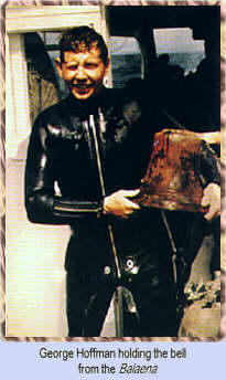
shipwreck, wooden hull full of coal
A wood sailing ship in the Mud Hole at a depth of 170 feet. She was a collier or ore carrier. She is still largely intact, coal in what's left of her holds. Divers tell tales of finding lots of deadeyes, but I haven't seen or heard of one coming from this wreck in many years. Her bell was found to identify her name, but not much else has been discovered about her history. A dive for the very experienced diver. Limited visibility, deep and dark. For those with the technical dive skill, it is a very nice dive.
More: Balaena ...
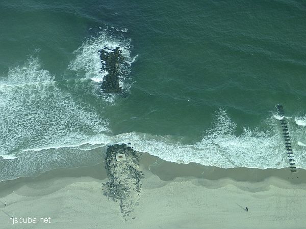
Dozens of jetties up and down the coast have been cut-though at the base like this one, making them inaccessible to fishermen, but not divers !
More: Beach Jetties ...
FE327SS/89 -- OPR-C147-HE-89; CONTACT #15 FROM SURVEY H-10284/88; DIVER INVESTIGATION FOUND A 45 FT STEEL WRECK RESTING KEEL UP ON A HARD, SANDY BOTTOM; WRECK WAS INTACT BUT NO NAME OR MARKINGS COULD BE LOCATED; HIGHEST POINT ON WRECK WAS THE STERN ON ONE OF THE TWO SKEGS; TWIN PROPS REMAIN ON THE WRECK; WRECK RISES 4 FT OFF THE BOTTOM; 44 FT PNEUMATIC DEPTH GAUGE LEAST DEPTH. (REV. 3/22/96, SJV)
More: u04 - AWOIS 8084 ...
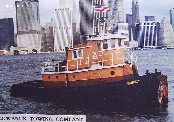
- Type:
- shipwreck, tugboat
- Built:
- maybe 1948, Bellinger Shipbuilding, Jacksonville FL as Barbara ???
- Specs:
- ( 47 ft )
- Sunk:
- circa 1971
- Depth:
- 60 ft
More: Nautilus ...