Beth Drydock No. 5
- Type:
- artificial reef, drydock (3 sections)
- Built:
- ?
- Specs:
- ( 133 x 96 x 54 ft )
- Sunk:
- May 20, 1985
- GPS:
- 38.515281 -74.525933
- Depth:
- 120 ft
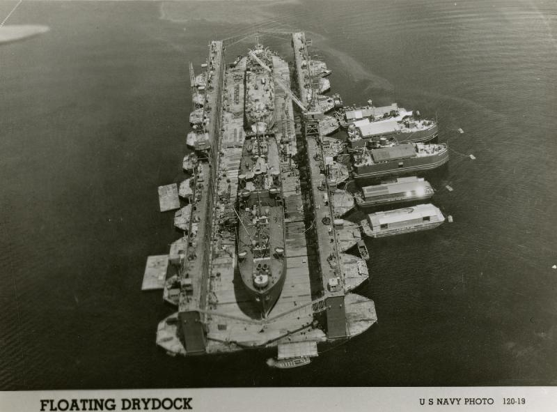
I can't find anything solid about these except the AWOIS listing. The photo above is an example of a sectional floating drydock, World War II era. In the photo, you can see how 10 barge-like sections are rafted-together to form one large structure.
Here is the AWOIS listing for one of them:
00764 - Beth Drydock No. 5
Wreck - Submerged, dangerous to surface navigation
HISTORY
CL537/85 - VESSEL SUNK IN APPROX. 125 FT. WITH A CLEARANCE OF 71 FT. FROM TOP OF VESSEL TO SURFACE IN LAT. 38-30.91N, LONG. 74-31.58W.
SUNK ON 5/20/85 BY BETHLEHEM STEEL CORP.
DESCRIBED AS ONE SECTION OF A SIX SECTION DRYDOCK, 133 FT. X 96 FT. X 54 FT.
SUNK APPROX. 27 MILES DUE EAST OF INDIAN RIVER INLET, DE.
LORAN-C COORDINATES (9960 CHAIN) 26928.4-X, 42470.9-Y.
SUNK IN COMPLIANCE WITH MARINE PROTECTION, RESEARCH, AND SANCTUARIES ACT, 40 CFR PART 229.3.
CONTACT IS WILLIAM J. HOFFMAN CHIEF, WETLANDS AND MARINE POLICY SECTION, EPA REGION III (PHILADELPHIA, PA).
SEE AWOIS NUMBERS 00763, 00765.
SURVEY REQUIREMENTS
FULL - VERIFY OR DISPROVE THROUGH 400% SIDE SCAN SONAR SEARCH OR WIRE SWEEP INVESTIGATION, 1 MILE MIN. RADIUS.
NOT ASSIGNED.
These were sunk some twenty years before the DelJerseyLand reef was established, and Delaware does not include them in any listing. However, they are charted at basically the same locations as the AWOIS listing, which is marked as low accuracy. Given their size, they should not be hard to find. (The Loran TDs convert to half a mile away, though!)
Philadelphia Naval Shipyard had a Dry Dock No. 5, but it was not a floating drydock. Bethlehem Steel has a shipyard in Baltimore to this day. These could also have been part of the James River mothball fleet, like the Algol. The fact is, I cannot find any records at all, except one note that suggests they have "massive two-foot by two-foot square timbers". That entire article is confused, and is probably referring to graving blocks, not the structure itself, which is almost certainly steel.
It would be interesting to know how the DJL reef came to be so close to the drydocks, but not enclose them. Did the reef planners not know about them? They are not mentioned in any publication from Delaware.
If anyone has information on these, please send it!
Questions or Inquiries?
Just want to say Hello? Sign the .