Percidae is the second largest family of fishes in North America, after Cyprinidae (Minnows). They are not related to saltwater Perches, which they superficially resemble.
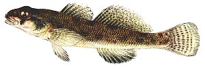
Darters are diminutive perches that inhabit quiet or slowly flowing waters. They swim in hops and spurts, mainly just sitting on the bottom as they search for the small invertebrates on which they feed. The Tessellated Darter Etheostoma olmstedi ( right, to 4.5" ) is the commonest in the area. Many midwestern species are brightly colored, but we are not so lucky, all of ours are drab.
More: Freshwater Perches & Darters ...