Recent Edits

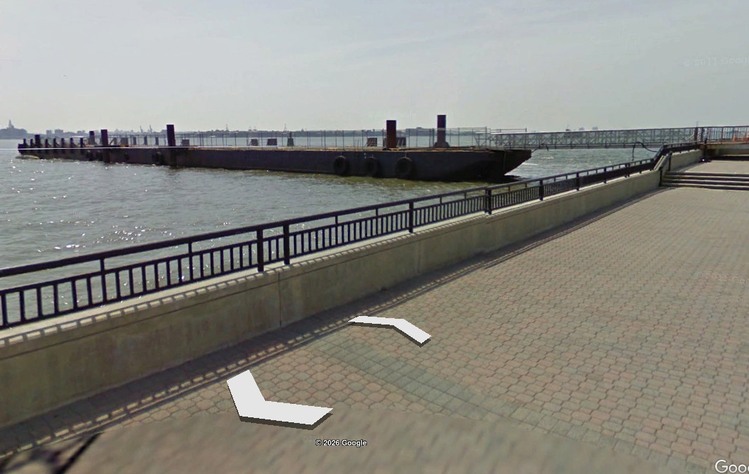
Delaware #9 Artificial Reef
4.5 Nautical Miles from Indian River Inlet, 1.31 sq miles
Depth: 50-60 ft
More: Delaware #09 Artificial Reef ...
Delaware #10 Artificial Reef
5.5 Nautical Miles from Indian River Inlet, 1.31 sq miles
Depth: 55-65 ft
More: Delaware #10 Artificial Reef ...
Delaware #11 Artificial Reef
15.5 Nautical Miles from Indian River Inlet, 1.52 sq miles
Depth: 70-90 ft
More: Delaware #11 Artificial Reef ...
- Type:
- artificial reef, car float barge, USA
- Specs:
- ( 330 x 40 ft ) cut into pieces
- Sponsor:
- NJDOT / NJDEP
- Sunk:
- Nov 2025 - Sea Girt Artificial Reef
- GPS:
- 40°07.793' -73°56.824'
40°07.832' -73°56.546'
40°07.859' -73°56.515'
40°07.952' -73°56.413' - Depth:
- 65 ft
The 330-foot car float barge Liberty was removed from the Hudson River in sections to clear space for a new ferry terminal at Liberty State Park. Formerly, Liberty was used at the park as a passenger-loading platform for ferries transiting to Ellis Island and the Statue of Liberty since 2005. It sank in a storm in 2020.
More: Liberty Barge ...
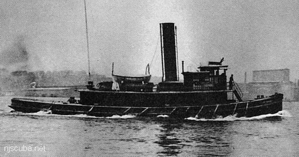
- Type:
- shipwreck, tugboat, USA
- Built:
- 1907, Neafie & Levy, Philadelphia PA USA
- Specs:
- ( 77 x 21 ft ) 122 gross tons, 13 crew
- Sunk:
- Thursday October 19, 1922
unknown, related to smuggling during Prohibition - no survivors - Depth:
- 80 ft
More: Lizzie D ...
- Type:
- shipwreck, freighter, USA
- Built:
- 1899, Harlan & Hollingsworth, Wilmington DE USA
- Specs:
- ( 263 x 29 ft ) 2825 tons, 34 crew
- Sunk:
- Friday May 27, 1932
collision with SS City of Chattanooga - 4 casualties - Depth:
- 95 ft
More: Grecian ...
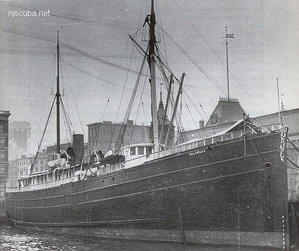
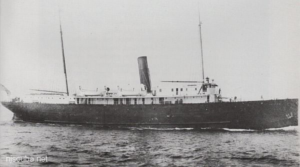
- Type:
- shipwreck, steamer, USA, Clyde Lines ( see Mohawk )
- Built:
- 1880, Hillman Ship & Engine Building, Philadelphia PA USA
- Specs:
- ( 250 x 37 ft ) 1646 gross tons, 66 passengers & crew
- Sunk:
- Saturday July 9, 1898
fire below decks, burned to waterline - no casualties - Depth:
- 75 ft
More: Delaware ...
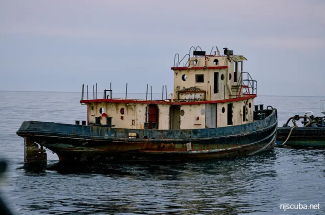
- Type:
- artificial reef, tugboat
- Built:
- 1944, Lawley & Sons, Neponset MA, as DPC-21
- Specs:
- ( 86 x 24 ft ) 146 GT, 9 crew
- Sunk:
- Saturday June 22, 2024 - Delaware #11 Artificial Reef
- GPS:
- 38°40.427' -74°43.073'
More: TD-21 DPC-21 ...
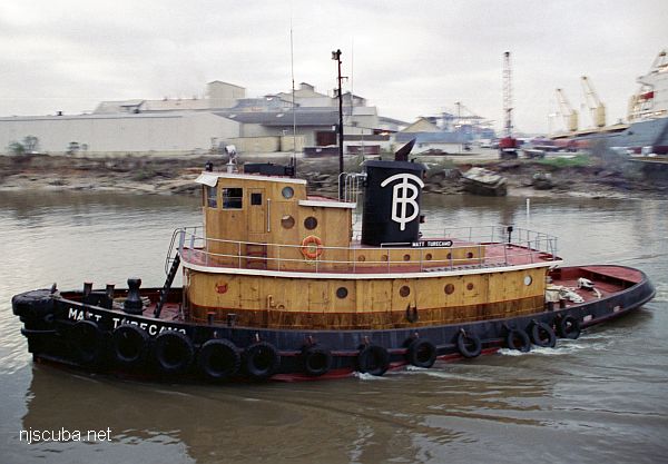
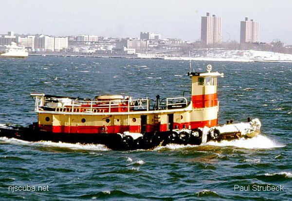
- Type:
- artificial reef, tugboat, U.S. Navy
- Built:
- 1943, Lawley & Sons, Neponset, MA as DPC-14, later Matt Turecamo
- Specs:
- ( 86 x 24 ft ) 146 GT, 9 crew
- Sponsor:
- Sean Maubray, FCO
- Sunk:
- Thursday October 17, 1996 - Sea Girt Artificial Reef
- GPS:
- 40°07.514' -73°56.465'
- Depth:
- 80 ft, main deck at 65 ft
More: Matt Turecamo DPC-14 ...
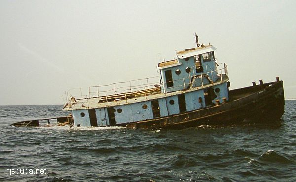
- Type:
- artificial reef, tugboat
- Built:
- 1943, Lawley & Sons, Neponset MA USA as DPC-15, later Brooklyn
- Specs:
- ( 86 x 24 ft ) 146 GT, 9 crew
- Sponsor:
- Friends of the Norma K
- Sunk:
- Tuesday October 30, 2001 - Axel Carlson Artificial Reef
- GPS:
- 40°03.390' -73°59.550'
More: Brooklyn DPC-15 ...
- Type:
- artificial reef, tugboat
- Built:
- 1943, Lawley & Sons, Neponset MA USA
- Specs:
- ( 86 x 24 ft ) 146 GT, 9 crew
- Sunk:
- Friday November 7, 2003 - Moriches Artificial Reef
- Depth:
- GPS:
- 40°43.470' -72°46.489'
More: JJ DPC-19 ...
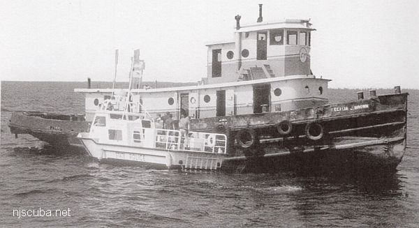
- Type:
- artificial reef, tugboat, USA
- Built:
- 1944, Decatur Iron & Steel, Decatur AL USA
- Specs:
- ( 86 x 24 ft ) 146 GT, 9 crew
- Sponsor:
- Cape May County Party & Charter Boat Association, Artificial Reef Association, Sportfish Fund
- Sunk:
- Monday August 16, 1993 - Cape May Artificial Reef
- GPS:
- 38°52.950' -74°40.200'
- Depth:
- 60 ft
More: Cecilia J Brown DPC-42 ...
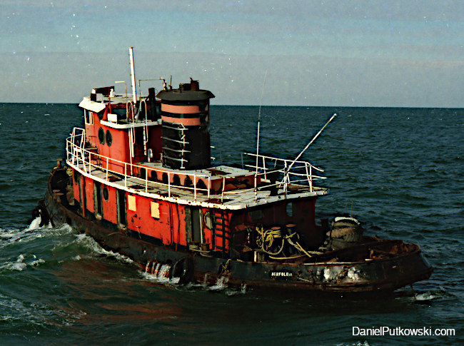
- Type:
- artificial reef, tugboat
- Built:
- 1943, Decatur Iron & Steel, Decatur AL as DPC-65
- Specs:
- ( 86 x 24 ft ) 146 GT, 9 crew
- Sunk:
- Friday Jan 15, 1999 - Delaware #11 Artificial Reef
- GPS:
- 38°40.540' -74°43.957'
- Depth:
- 75 ft
More: Delilah DPC-65 ...
- Type:
- shipwreck, schooner barge
- Built:
- 1916, Elkton MD USA
- Specs:
- ( 199 x 24 ft ) 474 tons
- Sunk:
- Monday March 31, 1924
foundered in storm, 5 casualties ( see Pocono ) - Depth:
- 65 ft
More: Plymouth ...
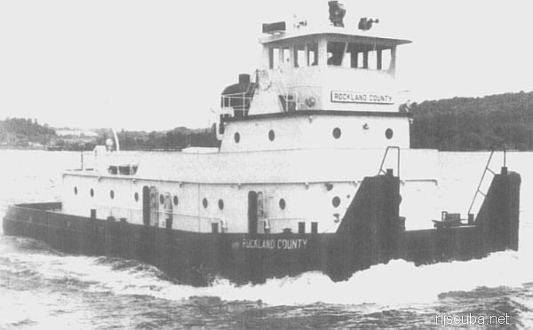
- Type:
- artificial reef, towboat
- Built:
- 1960, Dravo, Wilmington DE USA
- Specs:
- ( 105 x 24 ft )
- Sponsor:
- Spentonbush Red Star Company
- Sunk:
- Friday February 14, 1986 - Sea Girt Artificial Reef
- GPS:
- 40°07.942' -73°55.879'
- Depth:
- 80 ft
More: Rockland County ...
Cape May Chart
- 44009 Weather Buoy
- Absecon Inlet
- USS Akron
- Alex Gibson
- Alexander
- Almirante
- American
- Astra
- Atlantus
- Azua
- Dorothy B Barrett
- Brigantine Beach Wreck
- USS Blenny
- boiler wreck
- Brian C
- Brigantine Inlet
- Brigantine Buoy Wreck
- Charles Morand
- Cape May Inlet
- Cassandra
- Cayru
- Champion
- USS Cherokee
- China Wreck
- City of Athens
- City of Georgetown
- Clermont
- Corson’s Inlet
- William B Diggs
- dredge
- Admiral DuPont
- Elizabeth Warren
- Evening Star
- car float
- Florida
- Galimore's Cayru
- Gory Wreck
- Great Egg Inlet
- Gypsum Prince
- Hereford Inlet
- Hornet
- Hvoslef
- India Arrow
- Indian River Inlet
- USS Jacob Jones
- John Marvin
- China Junk Wreck
- Kennebec
- King Cobra
- Lemuel Burrows
- Lake Frampton
- Lady Mary
- Linda Snow II
- Marine Electric
- Miraflores
- Misty Blue
- Mohawk
- Montgomery
- USS Moonstone
- EF Moran
- Northern Pacific
- Nuphar
- Oklahoma
- Patrice McAllister
- Pet Wreck
- Poseidon
- Ranald
- RJ Walker
- Southern Lillian
- USS S-5
- Salem
- Salem
- San Jose
- Sea Girt
- Shookus
- Sindia
- Slabs
- General Slocum
- Southern Sword
- Townsend's Inlet
- Varanger
- Wayne
- Wily Fox
- YP-387
More: Cape May Dive Sites Chart ...
N.J. Shore inlet to be surveyed after large sandbar forms
By Nicolas Fernandes
NJ Advance Media for NJ.com
Aug. 17, 2022
Sand piling up in Manasquan Inlet
Andrew Mills | NJ Advance Media for NJ.com
The Army Corps of Engineers will visit the Manasquan Inlet next week to survey a large sandbar that has formed in the waterway, U.S. Rep. Chris Smith, R-4th Dist., said Wednesday.
Sands at the inlet have shifted before, but the low-tide sandbar is larger than anything seen there before, the congressman said.
"We are gravely concerned that it will pose a serious hazard to navigation," Smith said.
More: Manasquan Inlet Filling In ...
Delaware Artificial Reefs
Delaware has a string of artificial reef sites in the Delaware bay, but they are of little interest to divers. Most of the sites are quite shallow and perilously close to the shipping lanes, several of them were actually reduced for this reason. The conditions in the bay are hardly good for diving. The reefs consist mostly of concrete rubble from construction in Philadelphia and other cities on the river. Also shown is New Jersey's sole artificial reef in the bay.
More: Delaware Bay Reefs ...
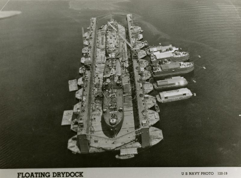
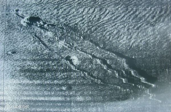
- Type:
- artificial reef, drydock (3 sections)
- Built:
- ?
- Specs:
- ( 133 x 96 x 54 ft )
- Sunk:
- May 20, 1985
- GPS:
- 38.515281 -74.525933
- Depth:
- 120 ft
More: Beth Drydock No. 5 ...
- Type:
- sport boat
- Specs:
- ( 35 ft )
- Sponsor:
- Elmer Dowd; Sportfish Fund
- Sunk:
- Saturday Oct 23, 1993 - Cape May Artificial Reef
- GPS:
- 38°51.700' -74°42.900'
- Depth:
- 70 ft
Another mystery
More: Georgia ...
The Office of Coast Survey's Automated Wreck and Obstruction Information System (AWOIS) contained information on over 10,000 submerged wrecks and obstructions in the coastal waters of the United States. Information included latitude and longitude of each feature along with brief historic and descriptive details. The AWOIS system has been discontinued, the replacement is here.
More: AWOIS Database ...
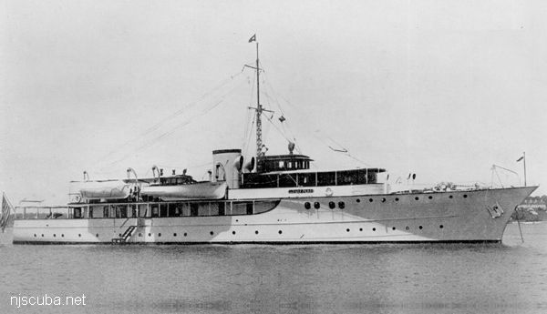
- Type:
- shipwreck, patrol boat, U.S. Navy (converted yacht)
- Built:
- 1929, Germany, as Lone Star
- Specs:
- ( 171 x 26 ft ) 469 gross tons, 47 crew
- Sunk:
- Friday October 15, 1943
collision with destroyer USS Greer ( 1090 tons) - no casualties - Depth:
- 130 ft
More: USS Moonstone PYc-9 ...
I have plotted over 1300 local listings from the AWOIS database here:
New Developments in Artificial Reefs
By Evelyn DeWitt Myatt & Bill Figley, 1986
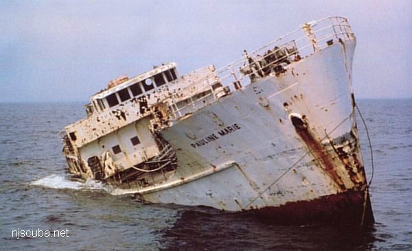
It's hard to imagine anything that could have looked more forlorn than the rusty old freighter whose proud seagoing days were a thing of the past. Floating idly at her berth awaiting her fate, she was a victim of nature's ravages that had left her beautiful only in the eyes of her old captain and crew. The Pauline Marie, however, was not destined to be the victim of a cutting torch that would turn her into a tangle of scrap steel. Instead, she was acquired by the New Jersey Artificial Reef Program and went down with dignity as an artificial reef in March 1985. She now provides continuing services from her watery grave in the Atlantic, some twelve miles off Atlantic City, and her appeal to marine life is undeniable. Her interior compartments now shelter fish and crustaceans; her decks now provide substrate for mussels, soft corals, and plant life; and her newfound productivity has put delicious seafood on many tables.
More: Artificial Reefs History ...
DelJerseyLand Inshore Artificial Reef
26 Nautical Miles from Indian River Inlet, 1.51 sq miles
Depth: 120-140 ft [download]
More: DelJerseyLand Artificial Reefs ...
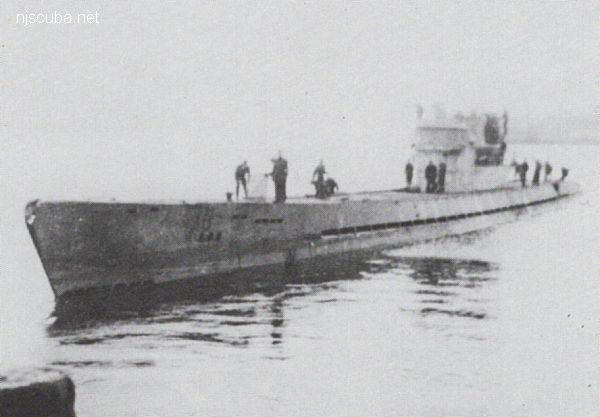
- Type:
- shipwreck, submarine, private
- Built:
- 1906, Lake Torpedo Boat Company, Newport News, VA USA,
as Simon Lake XV - Specs:
- ( 92 x 13 ft ) 200 tons
- Sunk:
- 1946, scuttled
More: Defender ...
Date: May 1968
- Type:
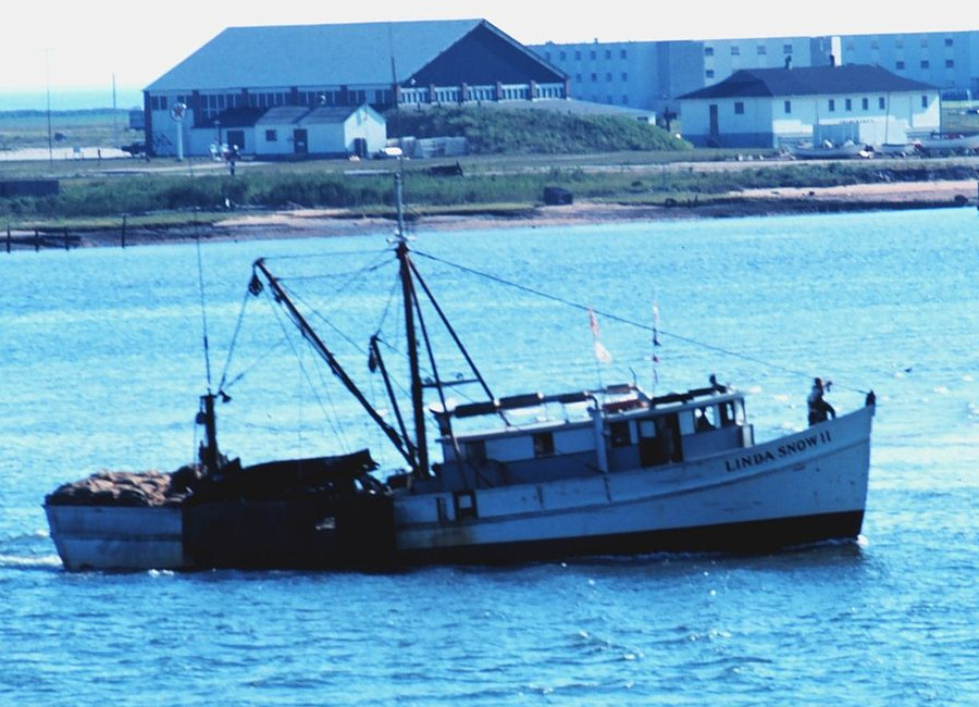
- shipwreck, clam dredge, USA
- Built:
- 1962, St Augustine, FL USA
- Specs:
- ( 66 x 18 ft ) 74 gross tons
- Sunk:
- Monday, Jan 16, 1978
capsized
More: Linda Snow II ...
- Home ...
- Dive Sites ...
- Artificial Reefs ...
- Marine Biology ...
- Artifacts ...
- Gear & Training ...
- Blog ...
- Cozumel ...

Welcome to NJScuba.net, a website dedicated to exploring the New Jersey / New York region underwater -- "Wreck Valley". Here you will find information on dive sites, marine biology, artifacts and activities, gear and training, and many other subjects.
More: Home ...