Sandy Hook Artificial Reef
1.6 nautical miles off Sea Bright, 1.76 sq miles
Depth: 40-60 ft [download]
More: Sandy Hook Artificial Reef ...
Long Island - Central Chart
More: Long Island Central Dive Sites Chart ...
Sandy Hook Artificial Reef
1.6 nautical miles off Sea Bright, 1.76 sq miles
Depth: 40-60 ft [download]
More: Sandy Hook Artificial Reef ...
The "Seawolf", as she is called, is a large steel-hulled wreck that faces in an easterly direction. Her bow rises 14 ft or so off the bottom. Most of the wreck comes off the bottom only a few feet. She has a large fishing net draped over her midships.
More: Seawolf ...
Shark River Artificial Reef
15.6 Nautical Miles off Manasquan, 0.83 sq miles
Depth: 120-140 ft [download]
More: Shark River Artificial Reef ...
The Shrewsbury Rocks are a wide area of rocky bottom that stretches from fourteen feet of water out to the fifty-foot mark off of Monmouth Beach. Some of the formations are twenty feet tall or more and can be very pretty under good conditions, which are unfortunately seldom this far north. The stone itself is a type of sandstone known as Greensand.
More: Shrewsbury Rocks ...
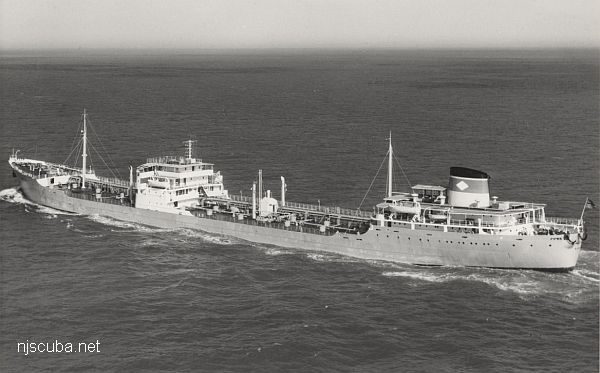
More: Stolt Dagali ...
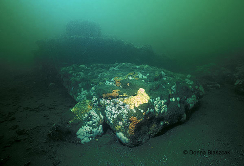
The "Three Sisters", as she is called, is an unidentified wooden-hulled vessel. She sits in 80 ft of water some 13 miles south of Atlantic Beach Inlet. She sits on a sandy bottom, spread out over a small area. Her boiler and a 4 bladed propeller are still visible. Wooden beams and planking spread out from the boilers aft towards the propeller. Occasionally some artifacts are found, mostly brass fittings. This is generally a decent wreck for lobsters and spearfishing. This wreck is in a main shipping channel, and large vessels make large wakes, so secure all gear.
More: Three Sisters ...
The Train Wheel Wreck is another unidentified wooden schooner. She is located in 120 feet of water only a few miles from the G&D Wreck. According to Jimmy Fazzolare divers will find a pile of train wheels and wooden debris. The Train Wheels must have been cargo. In the center of the wreck is a depression where divers can usually find big lobsters.
More: Train Wheel Wreck ...
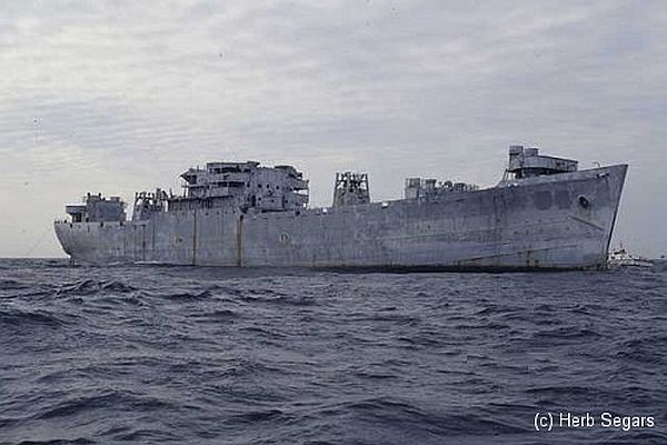
More: USS Algol AKA-54 ...
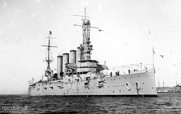
More: USS San Diego ACR-6 ...
I have found no correlation between good visibility and anything else at all. Calm seas certainly don't hurt, but the worst visibility I have ever been in was with a 1-foot surf on the beach. There is however a very good correlation between bad visibility and storms, which is why a single hurricane can end the season.
Other factors which influence visibility are: algae blooms, spawning seasons of some invertebrates, which can fill the water with tiny swimmers, jellyfish ( yes, so many you can't see through them, luckily they don't sting, ) other divers churning up the bottom, and just plain gunk in the water. I don't know how to predict most of these, except to say that if you dive a lot, sooner or later you will see some good visibility. Sometimes in the ocean, the visibility will be different in different depth layers. I have seen the viz go from 3 ft on the way down the anchor line to 20 ft on the wreck.
More: Visibility ...