Long Island West Dive Sites (3/10)
Long Island - Central Chart
- 3 Sisters
- 3/4 Tug
- 44069 Weather Buoy
- 59-Pounder
- Acara
- Across
- Arnoff
- Arundo
- Asfalto
- Ayuruoca
- BA Wreck
- Balaena
- Bald Eagle
- USS Benson
- Beth Dee Bob
- Blue Boy
- Burnside
- Catamount
- Choapa
- coal (Lido)
- Coastwise
- Continent
- Dodger
- Dragger
- Drumelzier
- drydock
- Edwin Duke / Stone Barge
- dump
- East Rockaway Inlet
- Eureka
- Fire Island Inlet
- Gate City
- Gluckauf
- I.P. Goulandris
- Gypsy
- Happy Days
- Harvey's Schooner
- Howard
- Hylton Castle
- Iberia
- Immaculata
- Irma C
- Jones Inlet
- Jones Tug
- Kenosha
- Kismet Artificial Reef
- Larsen
- Linda
- Lizzie D
- Margaret
- R.C. Mohawk
- Moriches Inlet
- Old Yankee
- Oregon
- Pipe Barge
- Ponquogue Bridge
- Ruth Shaw
- Reggie
- Rockaway Belle
- Roda
- USS San Diego
- SC-209
- Sea Wolf
- Shinnecock Inlet
- Sommerstad
- Steel Wreck
- Stolt Dagali
- USS Tarantula
- Train Wheel
- Valerie E
- Wolcott
- Yankee (G+D)
- Yellowbar Artificial Reef
More: Long Island Central Dive Sites Chart ...
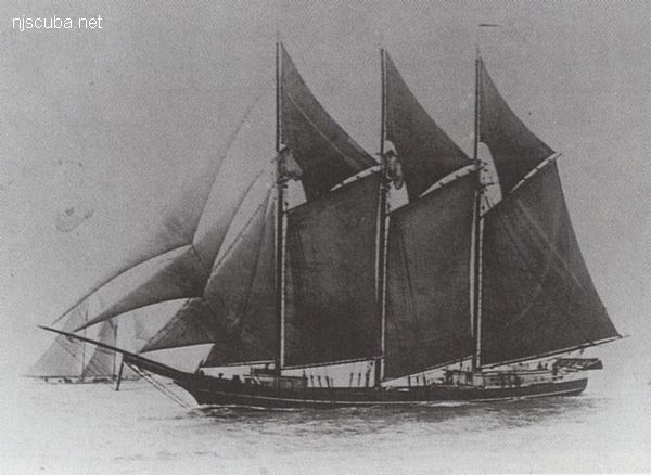
- Type:
- shipwreck, schooner, USA
- Specs:
- 306 tons, 6 crew
- Sunk:
- Saturday April 26, 1902
ran aground in bad weather - no casualties - GPS:
- 40°25.992' -73°10.620' (AWOIS 2013)
- Depth:
- 25 ft
More: Cornelia Soule ...
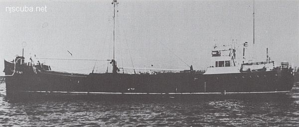
- Type:
- shipwreck, freighter, England
- Built:
- 1895, England
- Specs:
- ( 340 x 45 ft ) 3625 gross tons, 30 crew
- Sunk:
- Monday December 25, 1904
ran aground in snow storm, incompetence - no casualties - Depth:
- 20 ft
More: Drumelzier ...
- Type:
- shipwreck, dry-dock barge
- Depth:
- 110 ft
This anonymous big rectangular wooden dry-dock barge lies off Asbury Park, out near the edge of the Mud Hole. It is similar to the better-known Immaculata. The hulk of the wreck rises up as much as 10 feet, partially intact, while the upper sides have collapsed into the silty sand. Holes in the main wreckage allow penetration into the dark interior, which is surprisingly barren. A debris field of large rectangular ballast stones, wooden ribs, and rusted machinery extend from the western edge of the wreck, and to a lesser extent all around it. In exceptional late October fifty-foot visibility the view of this wreck from above was impressive, but overall this is not a very pretty site, and it is seldom dived. Good for lobsters, Sea Bass, scallops, and decompression.
More: drydock barge ...
East Rockaway Inlet
The dive site is between 8th and 9th Streets.
Atlantic Beach bridge at right, inlet and ocean to the left (west)
In Queens borough, New York City!
East Rockaway Inlet is also known as Deb's Inlet, while New Yorkers optimistically, or perhaps ironically, call the Beach 8th Street dive site Almost Paradise. (Actually the name of a long-defunct dive shop there.) It is also referred to as Beach 9th Street. If that's not enough names for the same place, the waterway is officially called Reynold's Channel. So I suppose you could make six different entries in your logbook.
Beach 8th Street is the only part of the inlet that is accessible to divers, the rest is either private property or state park land where diving is prohibited. You can zoom, pan, and maximize the map above. The inlet is off to the left, marshland to the right, and Kennedy Airport above.
More: East Rockaway Inlet / Beach 8th Street ...
More: Ed's Schooner ...
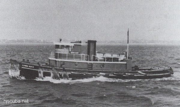
More: Edwin Duke ...