Long Island Sound Dive Sites (3/4)
Long Island Sound - West Chart
- 44039 Weather Buoy
- Amsterdam
- Atlantic
- Barataria
- USS Bass
- Bayville barge
- Black Point
- Celtic/Cape Race
- Condor
- HMS Culloden
- Defender
- John A. Downs
- Essex
- Gwendoline Steers
- USS G-1
- USS G-2
- Grecian
- Horton's Point / Commodore
- Huntington Artificial Reef
- HMS Hussar
- USS L-8
- Larchmont
- Lexington
- Lightburne
- Malden
- Matinecock Artificial Reef
- Mattituck Inlet
- Mattituck Artificial Reef
- Montauk Inlet
- Mount Sinai Harbor
- Myronus
- USS Ohio
- Olinda
- Poling Bros #2
- Port Jefferson Artificial Reef
- Port Jefferson Inlet
- Shoreham Nuclear Power Plant
- Smithtown Artificial Reef
- Snug Harbor
- Thames
- Thelma Phoebe
- U-853
- Volund
- Delaware River Water Gap
Long Island Sound - East Chart
- 44039 Weather Buoy
- Amsterdam
- Atlantic
- Barataria
- USS Bass
- Bayville barge
- Black Point
- Celtic/Cape Race
- Condor
- HMS Culloden
- Defender
- John A. Downs
- Essex
- Gwendoline Steers
- USS G-1
- USS G-2
- Grecian
- Horton's Point / Commodore
- Huntington Artificial Reef
- USS L-8
- Larchmont
- Lexington
- Lightburne
- Malden
- Matinecock Artificial Reef
- Mattituck Inlet
- Mattituck Artificial Reef
- Montauk Inlet
- Mount Sinai Harbor
- Myronus
- USS Ohio
- Olinda
- Poling Bros #2
- Port Jefferson Artificial Reef
- Port Jefferson Inlet
- Shoreham Nuclear Power Plant
- Smithtown Artificial Reef
- Snug Harbor
- Thames
- Thelma Phoebe
- U-853
- Volund
- Delaware River Water Gap
Long Island Sound averages 60 ft in depth, with the greatest depth of over 300 ft at the eastern end. Tidal effects are strongest at the narrow western end, where all the inrushing water flow piles up and makes tidal variations of up to 7 ft. Strong tidal currents are also prevalent, and visibility tends to be poorer than the open ocean, especially at depth.
More: Long Island Sound Dive Sites Chart ...
Mount Sinai Harbor
Once you get there, suit up at your car and walk down the small stretch of beach till you get near the jetty. Enter the water at your leisure. Once in the water, you can swim north along the jetty to the tip. You may see fish, lobster, crabs and the sort. There are large openings in the rocks that form the jetty. Large enough in fact that you can almost swim into one. I don't advise doing this because getting stuck might be a frightening experience.
More: Mount Sinai Harbor / Jetties ...
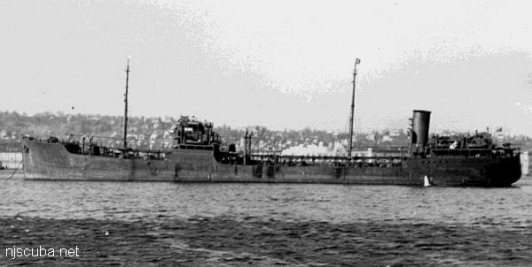
- Type:
- shipwreck, tanker, USA
- Built:
- 1863, USA
- Specs:
- ( 116 x 23 ft ) 159 tons
- Sunk:
- Wednesday February 7, 1940
struck pack ice - no casualties - Depth:
- 65 ft
More: Poling Brothers #2 ...
Port Jefferson Artificial Reef
1.79 nautical miles northeast of Port Jefferson Inlet, 0.08 sq miles
Depth: 88 to 94 feet
More: Port Jefferson Artificial Reef ...
Shoreham Nuclear Power Plant
Now, most people would look at the heading on the page and think that I was crazy for diving near a nuclear power plant. Just to calm your fears, this power plant was never brought online, so there is no chance of getting radiated at this location (barring a nuclear war while you're diving). With that said, Shoreham can be a very interesting dive. Located on the north shore of Long Island (I don't know the name of the town, look on a map), it is a shallow dive with an average depth of around 16 ft. Visibility tends to be anywhere from 3 to 10 ft.
More: Shoreham ...
Smithtown Artificial Reef
1.6 nautical miles northwest of Stony Brook Harbor, 0.05 sq miles
Depth: 30 - 40 ft
More: Smithtown Artificial Reef ...