Shinnecock Artificial Reef
Shinnecock Artificial Reef (historical)
( 40.80139, -72.47293 )
2.0 Nautical miles south of Shinnecock Inlet, 0.55 sq miles
Depth: 76 - 84 ft
Shinnecock Artificial Reef (now)
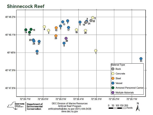
Shinnecock Reef was originally very small, but has been expanded greatly. The pink region is the historical area, and the blue region is the new deployment zone, while the full permitted size of the reef is a 1-nm square that encloses the deployment zone.
- Asylum is described as a 60' steel vessel, sunk 2025.
- "unknown" is described as a 46' steel hull pleasure craft, sunk 1987.
In the old version of the website, I had the names Marlu and Maroca recorded for this reef. When I got the new photos of most of the reefs, Maroca became apparent - it is spray-painted on the transom of the vessel. Marlu was harder, but I think I have that one figured out as well - New York lists it as a 70' vessel without a name. I also had a second drydock at Fire Island that I think belongs here. New York's reef program was moribund for so long that the records are unclear.
Reef site coordinates differ from NOAA Navigational Charts.
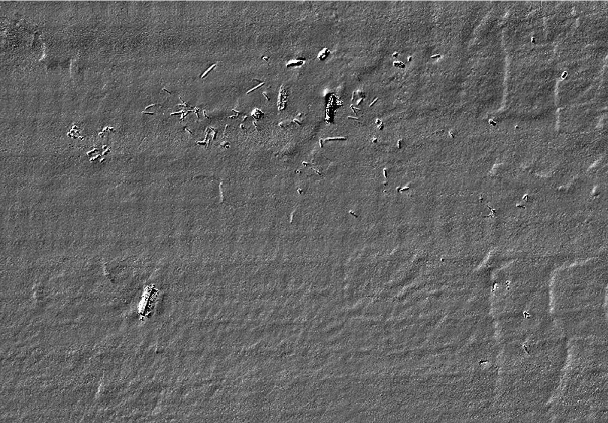
Note the remains of the drydock at lower-left, the square lighthouse at top-center, with Marlu and Mandy Ray to the right. The freckles at the upper-left are Army tanks.
- Type:
- artificial reef, trawler
- Built:
- 1968, Master Marine, Bayou La Bâtre AL USA
- Specs:
- ( 72x20 ft ) 131 gross tons
- Sunk:
- 1999-2000 - Shinnecock Artificial Reef
- Depth:
- GPS:
- 40°48.149' -72°28.501'
More: Marlu ...
- Type:
- artificial reef, trawler
- Built:
- 1983, Newport Shipyard, Newport RI, USA
- Specs:
- ( 126x25 ft ) 198 gross tons
- Sunk:
- October 16, 1998 - Shinnecock Artificial Reef
- Depth:
- GPS:
- 40°48.133' -72°28.500'
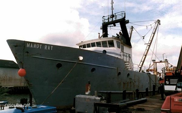
More: Mandy Ray ...
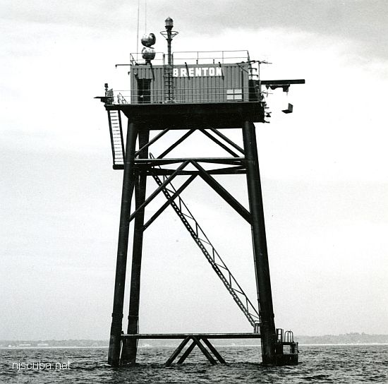
- Type:
- artificial reef, light tower, USA
- built:
- 1962, US Coast Guard
- Specs:
- 87 ft tall
- Sunk:
- Friday January 8, 1993 - Shinnecock Artificial Reef
- Depth:
- GPS:
- 40°48.139' -72°28.526'
More: Brenton Reef Lighthouse ...
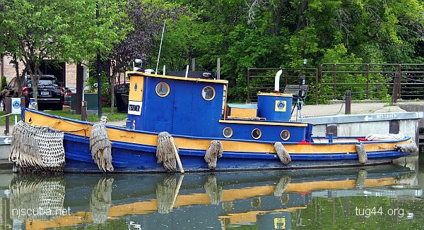
- Type:
- artificial reef, tugboat
- Built:
- late 1920s?
- Specs:
- ( 40 ft )
- Sunk:
- Thursday May 31, 2018 - Shinnecock Artificial Reef
- Depth:
- GPS:
- 40°48.071' -72°28.655'
More: Canal Tender 6 ...
- Type:
- artificial reef, barges
- Depth:
- 79 - 84 ft
| Name | Description | Sunk | GPS |
| 60 ft steel dredge |
1987 | 40°48.063' -72°28.622 |
|
| Caddell | 157 ft wood drydock |
Wednesday September 12, 1990 |
40°48.007' -72°28.634' |
| Dump Scow DS-106 |
100 ft steel | Wednesday June 20, 2018 |
40°48.179' -72°28.461' |
| Shannon C | 60 ft steel | Friday Nov 5, 2021 |
40°48.118' -72°28.390' |
| Henri | 130 ft steel | 2025 | 40°47.984' -72°28.486' |
More: barges - Shinnecock Artificial Reef ...
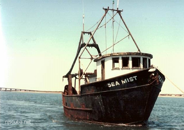
- Type:
- artificial reef, trawler, USA
- Built:
- 1976, Belhaven, NC USA ?
- Specs:
- ( 55 ft )
- Sunk:
- Saturday April 23, 1994 - Shinnecock Artificial Reef
- Depth:
- GPS:
- 40°48.173' -72°28.489'
More: Sea Mist ...