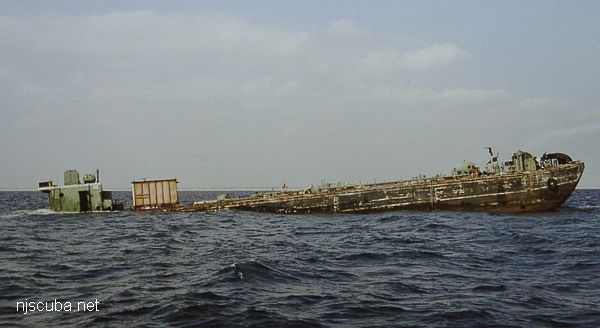
Atlantic Beach Artificial Reef
3.0 nautical miles south of Atlantic Beach, 0.64 sq miles
Depth: 55 - 64 ft
More: Atlantic Beach Artificial Reef ...
Atlantic Beach Artificial Reef
3.0 nautical miles south of Atlantic Beach, 0.64 sq miles
Depth: 55 - 64 ft
More: Atlantic Beach Artificial Reef ...
Fire Island Artificial Reef
2.0 nautical miles south of Fire Island Lighthouse, 1.33 sq miles
Depth: 62 - 73 ft
More: Fire Island Artificial Reef ...
Hempstead Artificial Reef
3.3 nautical miles south of Jones Beach State Park, 1.33 sq miles
Depth: 50-70 ft
Depth: 50 - 72 ft
More: Hempstead Artificial Reef ...
Huntington Artificial Reef
1.16 nautical miles northeast of Lloyd Point, 0.08 sq miles
Depth: 47 to 53 feet
More: Huntington Artificial Reef ...
Kismet Artificial Reef
120 yards north of South Beach, 0.01 sq miles
Between Kismet and National Seashore dock
This reef is very close to land, it could even be a shore dive
Depth: 16 - 25 ft
More: Kismet Artificial Reef ...
Matinecock Artificial Reef
More: Matinecock Artificial Reef ...
Mattituck Artificial Reef
2.37 nautical miles northwest of Mattituck Inlet, 0.08 sq miles
Depth: 72 to 100 feet
More: Mattituck Artificial Reef ...
McAllister Artificial Reef
2.8 nautical miles south of Long Beach, 0.67 sq miles
Depth: 50 - 53 ft
More: McAllister Artificial Reef ...
Moriches Artificial Reef (historical)
2.4 nautical miles south of Moriches Inlet, 0.54 sq miles
Depth: 70 - 75 ft
More: Moriches Artificial Reef ...
Port Jefferson Artificial Reef
1.79 nautical miles northeast of Port Jefferson Inlet, 0.08 sq miles
Depth: 88 to 94 feet
More: Port Jefferson Artificial Reef ...
More: Jim Lynch E-13 ...