Manasquan Dive Sites (9/10)

Manasquan Chart

  1. Barge #10
  2. 120 Wreck
  3. 3 Sisters
  4. Ambrose Buoy
  5. A Street - Shark River
  6. Across
  7. Adele
  8. Ajace
  9. Alex Mac
  10. Allenhurst Jetty
  11. Anastasia
  12. Antioch
  13. Arnoff
  14. Arundo
  15. Asfalto
  16. Aurora
  17. Ayuruoca
  18. BA Wreck
  19. Shark River - Back Bay
  20. Balaena
  21. Bald Eagle
  22. Barnegat Inlet
  23. BD1738
  24. USS Benson
  25. Beth Dee Bob
  26. Blue Boy
  27. Bonanza
  28. Brick barge
  29. Bronx Queen
  30. Brunette
  31. Cecilia M Dunlap
  32. Cornelius Grinnell
  33. Catherine Jackson
  34. Chauncy Jerome
  35. Caddo
  36. Cadet
  37. Capt Smitty
  38. Catamount
  39. Charlemagne Tower
  40. Chaparra
  41. Chesapeake
  42. Choapa
  43. clam boat
  44. Continent
  45. crane barge
  46. Creole
  47. Daghestan
  48. Delaware
  49. drydock
  50. Dryland
  51. dump
  52. Duncan
  53. Edmund Phinney
  54. Elberon Rocks
  55. Emerald / USS Hibiscus
  56. Eureka
  57. Francis A Perkins
  58. William R Farrell
  59. FF Clain
  60. Finance
  61. Fort Victoria
  62. Gassoon
  63. German
  64. Lady Gertrude
  65. GL78
  66. Glen II
  67. Glory Wreck
  68. I.P. Goulandris
  69. Granite Wreck
  70. Great Isaac
  71. Gulftrade (stern)
  72. Gulftrade (bow)
  73. Gypsy
  74. Horseshoe Cove
  75. Alexander Hamilton
  76. Hankins (Big)
  77. Hankins (Offshore)
  78. Hankins 3
  79. Happy Days
  80. Cornelius Hargraves
  81. Harry Rush
  82. Harvey's Schooner
  83. Thomas Hebert
  84. Ida K
  85. Immaculata
  86. Inshore barge/tug
  87. Irene/Truro
  88. Irma C
  89. John Minturn
  90. Jack I
  91. Joan La Rie III
  92. Klondike Rocks
  93. Lizzie H. Brayton
  94. Lana Carol
  95. Larsen
  96. Lavallette Wreck
  97. Leon Walter
  98. Lillian
  99. Lizzie D
  100. Long Branch locomotives
  101. Logwood
  102. H.W. Long
  103. Macedonia
  104. Mahogany
  105. Malta
  106. Manasquan Inlet
  107. Marion
  108. Maurice Tracy
  109. Mediator
  110. Meta
  111. Middle Barge
  112. Mistletoe
  113. R.C. Mohawk
  114. Mohawk
  115. Manasquan Wreck
  116. Nautilus
  117. Navesink River
  118. Northeast Sailor
  119. New Reef
  120. New Deal
  121. New Era
  122. NW Barges
  123. Olsen
  124. HMS Pentland Firth
  125. Park City
  126. Peerless
  127. Persephone
  128. Long Branch Pier Rubble
  129. Pinta
  130. Pliny
  131. Plymouth
  132. Pocopson
  133. Remedios Pascual
  134. Ruth Shaw
  135. Ramos
  136. Ranger
  137. Reliable
  138. Relief Lightship
  139. Rickseckers
  140. Ridge Schooner
  141. Riggy
  142. Rjukan
  143. Rockaway Belle
  144. Roy's barge
  145. RP Resor
  146. Manasquan River Railroad Bridge
  147. Rudder Wreck - Pocono
  148. Rump
  149. Rusland / Adonis
  150. Scotland Buoy
  151. San Saba
  152. Sandy Hook Pilot Boat
  153. SC-60
  154. Sea Girt Inlet
  155. Sea Girt Wreck
  156. Sea Hag
  157. Seaside Crane Barge
  158. Shark River Inlet
  159. Shrewsbury Rocks
  160. Simala
  161. Spring Lake Sailor
  162. Steel Wreck
  163. Stolt Dagali
  164. Sumner
  165. Southwest Mohawk
  166. Sylvanus
  167. Tampa III
  168. Thurmond
  169. Tolten
  170. Train Wheel
  171. Troop Carrier
  172. USS Turner
  173. AWOIS 8087
  174. AWOIS 8097
  175. u11
  176. AWOIS 7509
  177. AWOIS 7932
  178. AWOIS 9768
  179. AWOIS 12966/11422
  180. AWOIS 1609
  181. AWOIS 8084
  182. AWOIS 7940
  183. AWOIS 7938
  184. AWOIS 8076
  185. AWOIS 4600
  186. AWOIS 8075
  187. Valerie E
  188. Vega
  189. Vivian
  190. Vizcaya
  191. Warrior
  192. Western World
  193. Edward W Winslow
  194. Edward W Winslow
  195. Yankee (G+D)
  196. Yellow Flag
  197. ZPG-3W
 Page 1  8 9 10  

At Point Pleasant, 1981

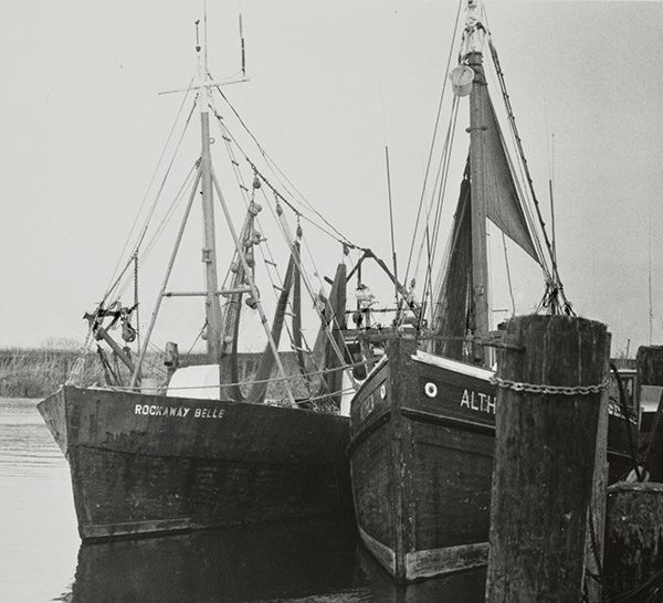
Rockaway Belle is listed as Army tug-transport T-1, built by Simms Brothers, Dorchester MA, 1942. 'T-boats' were 65-foot, 45 ton diesel-powered, passenger-cargo boats that doubled as harbor tugs. 170 of them were constructed during WWII, and many more afterwards. From 1940 through 1951 all T-Boats were built of wood, thereafter steel. Rockaway Belle was T-1 of the T-1 class, sold as surplus in 1947.

Rockaway Belle sank some time after 1977, there is a record of her active then.


Shipwreck Rump
A spike protrudes from wooden decking
Type:
shipwreck, schooner barge
Specs:
approximately 150 ft
Depth:
80 ft

Sea Girt Inlet

Sea Girt Inlet is reduced to an outflow pipe. The water it releases is often so contaminated with goose droppings that it causes beach closings for miles around.


Sea Girt Artificial Reef

3.6 Nautical Miles off Sea Girt, 1.33 sq miles
Depth: 60-75 ft [download]


Type:
shipwreck, barge
Specs:
( 250 ft ? )
Depth:
85 ft
compass

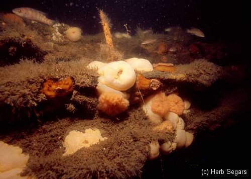
A very large intact steel deck barge, lying upright, north-south. The southern end is partially collapsed and opened up, allowing easy access to at least part of the inside. Rust holes in the deck let light in throughout the rest of the interior, although they are too small to fit through. A great spearfishing site, and not bad for lobsters. The crane lies about 1/4 mile away.


Shark River - Looking back from the end of the south jetty
Looking back from the end of the south jetty.
Type:
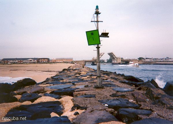
smallish tidal river inlet with stone jetties or bulkheads on both sides
Depth:
15 ft

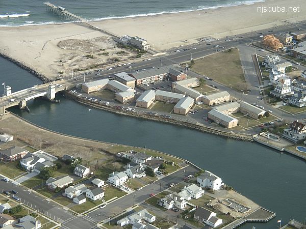
The Shark River is your best bet for shore diving in the northern half of the New Jersey coastline, far better than the Manasquan River. Shark River offers at least four different locations to dive: either side of the inlet, with rock jetties to explore, slightly upstream at A Street in Belmar, and upriver in the back bay area at L Street, Belmar. The wreck of the Malta is also just a few blocks south on the beach, but hardly worth diving.


Shark River - A Street
View of the up-river area, looking southeast. Either side is diveable upstream to the first road. The entry location is just to the right of the apartments.

Yet another place to dive the Shark River is on the south side, near the intersection of 1st Avenue and A Street, behind the apartments. There is limited but very convenient free parking. A small cement stairway leads down to a concrete ledge above the water. Climb down between the big rock and the bulkhead, where you will find more steps underwater. ( Whoever B.M and M.M. are - thank you! )


Shark River Bay Aerial
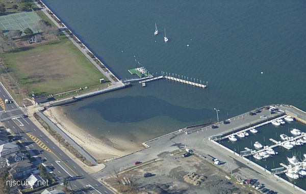
The new steps are just off the top edge of the photo, past the tennis courts.
Type:
inland tidal bay
Depth:
20 ft max, 15 ft in most places

This dive site, formerly known as 'L Street' has changed completely, and for the better. The town of Belmar has done something really nice for us divers and installed wide wooden steps down the bulkhead in Maclearie Park. This more than makes up for the loss of the boat ramp area, which is off-limits to all swimmers since it was rebuilt. I suppose the little cove by the ramp is still accessible from the beach, but the new site is much better, and far from all the dangerous boat traffic around the ramp and marina.


Cape May Artificial Reef

8.5 Nautical Miles off Cape May, 5.34 sq miles
Depth: 50-75 ft [download]