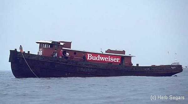
Colleen
- Type:
- artificial reef, tugboat
- Built:
- 1952, American Marine, New Orleans LA, USA
- Specs:
- ( 92 x 25 ft ) 150 tons
- Sponsor:
- GPPCBA, Budweiser, GDF
- Sunk:
- Saturday August 3, 1996 - Axel Carlson Artificial Reef
- GPS:
- 40°02.794' -73°59.350'
- Depth:
- 80 ft
The Colleen was a canal tugboat that towed barges on the Erie Canal between New York City and the Great Lakes. She also helped dock ships in port.
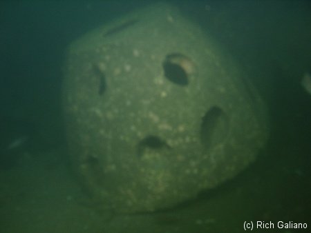
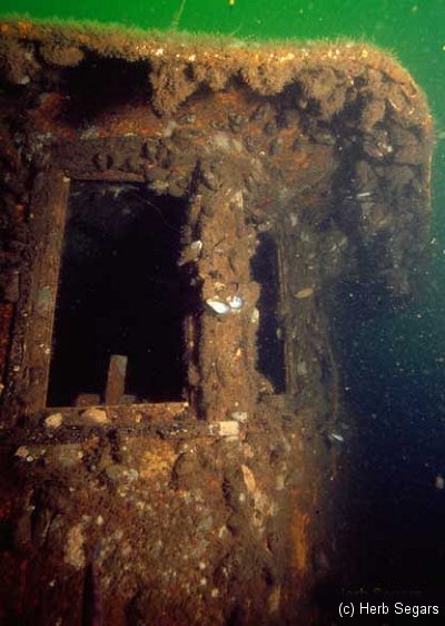
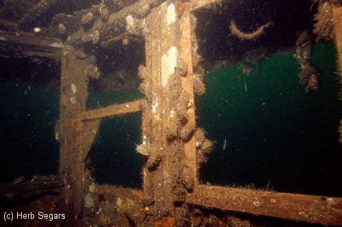
The Colleen is a near twin to the Spartan. At about 60 ft depth, large holes in the roof make it easy to drop down several decks inside the wreck and still have daylight in sight above. Look for lobsters dug in under the edges of the hull, along with a great many Sea Bass. The rudder is cranked 90 degrees to one side, leaving plenty of room to swim through the gap where the propeller should be. At least one APC lies close by off her stern, upside-down, and a reef ball lies on the aft deck.
Built in 1952, by Alexander Shipyard of New Orleans, Louisiana (hull #542) as the Rhea I. Bouchard for the Bouchard Transportation Company of Melville, New York. In 1952 the tug was acquired by the Moran Towing Company of New York, New York, and renamed Polly Moran. In 1958 she was acquired by Ira S. Bushey and Sons of Brooklyn, New York, and renamed Cardinal.
In 1972, the tug was acquired by the Kehoe Transportation Company of New York, New York and renamed Kehoe. However, the Kehoe Transportation Company later renamed the tug Colleen Kehoe. She was later acquired by the Mowbray Towing Corporation of New York, New York, and renamed Colleen. She was a single screw tug, rated at 900 horsepower.
tugboatinformation.com
Artificial Reef Sites, Artificial Reefs, Axel Carlson Artificial Reef, Moran Towing Company, New Jersey Artificial Reef Sites, New Jersey Artificial Reefs, Tugboats,
Axel Carlson Artificial Reef
- "small old wreck"
- Austin
- Barbara Ann
- Bay King
- big barge
- Brooklyn
- Manasquan Inlet Buoy
- Captain Bill
- Carrabassett
- Caterina.D
- Colleen
- crab barge
- Delaware
- Ed Schmidiger
- Glory Wreck
- Hail Mary
- Harbor Charlie
- Hillman III
- Jim Lynch
- Manasquan Inlet
- McGinty
- Megan Sue
- Middle Barge
- MRMTC 8
- MRMTC 9
- OWD III
- Patrick McHugh
- Riggy
- Rump
- Shark River Inlet
- Snug Harbor
- Swensen
2.0 Nautical Miles off Mantoloking, 5.19 sq miles
Depth: 65-80 ft [download]
More: Axel Carlson Artificial Reef ...
Manasquan Chart
- Barge #10
- 120 Wreck
- 3 Sisters
- Ambrose Buoy
- A Street - Shark River
- Across
- Adele
- Ajace
- Alex Mac
- Allenhurst Jetty
- Anastasia
- Antioch
- Arnoff
- Arundo
- Asfalto
- Aurora
- Ayuruoca
- BA Wreck
- Shark River - Back Bay
- Balaena
- Bald Eagle
- Barnegat Inlet
- BD1738
- USS Benson
- Beth Dee Bob
- Blue Boy
- Bonanza
- Brick barge
- Bronx Queen
- Brunette
- Cecilia M Dunlap
- Cornelius Grinnell
- Catherine Jackson
- Chauncy Jerome
- Caddo
- Cadet
- Capt Smitty
- Catamount
- Charlemagne Tower
- Chaparra
- Chesapeake
- Choapa
- clam boat
- Continent
- crane barge
- Creole
- Daghestan
- Delaware
- drydock
- Dryland
- dump
- Duncan
- Edmund Phinney
- Elberon Rocks
- Emerald / USS Hibiscus
- Eureka
- Francis A Perkins
- William R Farrell
- FF Clain
- Finance
- Fort Victoria
- Gassoon
- German
- Lady Gertrude
- GL78
- Glen II
- Glory Wreck
- I.P. Goulandris
- Granite Wreck
- Great Isaac
- Gulftrade (stern)
- Gulftrade (bow)
- Gypsy
- Horseshoe Cove
- Alexander Hamilton
- Hankins (Big)
- Hankins (Offshore)
- Hankins 3
- Happy Days
- Cornelius Hargraves
- Harry Rush
- Harvey's Schooner
- Thomas Hebert
- Ida K
- Immaculata
- Inshore barge/tug
- Irene/Truro
- Irma C
- John Minturn
- Jack I
- Joan La Rie III
- Klondike Rocks
- Lizzie H. Brayton
- Lana Carol
- Larsen
- Lavallette Wreck
- Leon Walter
- Lillian
- Lizzie D
- Long Branch locomotives
- Logwood
- H.W. Long
- Macedonia
- Mahogany
- Malta
- Manasquan Inlet
- Marion
- Maurice Tracy
- Mediator
- Meta
- Middle Barge
- Mistletoe
- R.C. Mohawk
- Mohawk
- Manasquan Wreck
- Nautilus
- Navesink River
- Northeast Sailor
- New Reef
- New Deal
- New Era
- NW Barges
- Olsen
- HMS Pentland Firth
- Park City
- Peerless
- Persephone
- Long Branch Pier Rubble
- Pinta
- Pliny
- Plymouth
- Pocopson
- Remedios Pascual
- Ruth Shaw
- Ramos
- Ranger
- Reliable
- Relief Lightship
- Rickseckers
- Ridge Schooner
- Riggy
- Rjukan
- Rockaway Belle
- Roy's barge
- RP Resor
- Manasquan River Railroad Bridge
- Rudder Wreck - Pocono
- Rump
- Rusland / Adonis
- Scotland Buoy
- San Saba
- Sandy Hook Pilot Boat
- SC-60
- Sea Girt Inlet
- Sea Girt Wreck
- Sea Hag
- Seaside Crane Barge
- Shark River Inlet
- Shrewsbury Rocks
- Simala
- Spring Lake Sailor
- Steel Wreck
- Stolt Dagali
- Sumner
- Southwest Mohawk
- Sylvanus
- Tampa III
- Thurmond
- Tolten
- Train Wheel
- Troop Carrier
- USS Turner
- AWOIS 8087
- AWOIS 8097
- u11
- AWOIS 7509
- AWOIS 7932
- AWOIS 9768
- AWOIS 12966/11422
- AWOIS 1609
- AWOIS 8084
- AWOIS 7940
- AWOIS 7938
- AWOIS 8076
- AWOIS 4600
- AWOIS 8075
- Valerie E
- Vega
- Vivian
- Vizcaya
- Warrior
- Western World
- Edward W Winslow
- Yankee (G+D)
- Yellow Flag
- ZPG-3W
More: Manasquan Dive Sites Chart ...
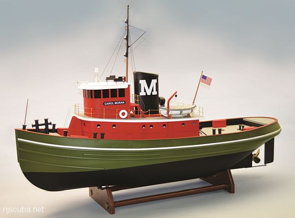
Founded in 1860, by Michael Moran as a towing and brokerage firm, the Moran Towing and Transportation Company of New York, New York. In 1863, the company transitioned from a brokerage firm to an owner/operator of towing vessels when the company acquired a one-half interest in the tugboat Ida Miller for $2,700. In 1880, Michael Moran painted the first white "M" on the stack of a Moran tugboat.
More: Moran Towing Company ...
Questions or Inquiries?
Just want to say Hello? Sign the .