Grecian (2/2)
Chapter 21: Grecian
reprinted from Shipwrecks of Rhode Island and Connecticut by Gary Gentile
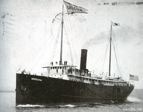
This picture-postcard was canceled in 1905. Ruth, the sender, penned the X and the diagonal line. On the obverse under the photograph, she wrote, "Where I performed miracles."
| Built: | 1900 |
| Previous names: | None |
| Type of vessel: | Passenger-freighter |
| Gross tonnage: | 2,827 |
| Dimensions: | 265' x 42' x 36' |
| Power: | Coal-fired steam |
| Builder: | Harlan & Hollingsworth, Wilmington, Delaware |
| Owner: | Merchants & Miners Transportation Corporation |
| Port of registry: | Baltimore, Maryland |
| Sunk: | May 27, 1932 |
| Cause of sinking: | Collision with SS City of Chattanooga |
| Depth: | 90 feet |
The Grecian was built as a passenger-freighter in 1900 for the Boston and Philadelphia Steamship Company. She routinely transported a hundred passengers and 2,500 tons of freight between the two eponymous ports that constituted her owner's name. The Grecian's hull was constructed of steel, as were three of her tiered decks; the hurricane deck was constructed of Oregon pine. Her hull was divided into five watertight compartments by four transverse bulkheads, "extending up through the orlop and lower decks to the main deck, and there is an additional bulkhead forward of the after peak bulkhead and extending up to the orlop deck. She had over 150,000 cubic feet of cargo space. Her bunker capacity was 293 tons of coal. Her water ballast capacity was 370 tons. She also carried 2,500 gallons of freshwater.
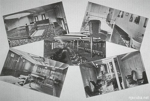
"Passenger accommodations on this vessel are very attractive. There is accommodation for about 100 passengers in the deck-house, and on the main deck, in the after part of the vessel. In the forward end of the deckhouse on either side is a cabin of large dimensions, fitted with large ports in the front and at the sides. Aft of this the dining saloon occupies the full width of the house, with a capacity for 95 passengers at one sitting. Further aft, and just forward of the boiler casing, is the pantry and serving rooms, with an elevator communicating with the galley below on the main deck.
In the space between the stack and engine casings are the officers' mess room and quarters for members of the engineers' and stewards' departments. These rooms open out on a'thwartships passage, on which also open the rooms of the chief and first assistant engineers so that access to the engine room can be had without going outside. There are staterooms abreast of the engine casing and truck of the after hatch on each side. In the after part of the deck structure is the social hall with cabins along each side and also at the after end of the house, all of these cabins opening into the hall and gallery.
Below on the main deck, and reached by a wide staircase, are the remainder of the staterooms, and accommodations for the twelve waiters in the tiller-room. In the superstructure over the main saloon comes in succession, the pilot-house, captain's and mates' rooms, officers' toilet room, and passengers' smoking room. The latter is a nice airy apartment and commands a fine view at the sides. There are good accommodations for the crew forward on the main deck. "In interior finish white and gold are used in the decoration of the saloon and social hall, paneled quartered oak and leather upholstery are used in the smoking-room, and the dining room is finished in mahogany."
The Grecian's triple expansion reciprocating steam engine could propel the vessel at better than fifteen knots. Four single-ended boilers provided steam. The cast iron propeller measured fifteen feet in diameter. On June 22 of her first year of operation, the Grecian lost her cast iron propeller off Chatham, Massachusetts, and had to be towed to port.
After Merchants & Miners acquired the Grecian, she was involved in a collision with the SS Evangeline. The collision occurred on the fog-shrouded night of June 28, 1928, near the Stone Horse lightship in the Pollock Rip Channel of Nantucket Sound. Both vessels sounded fog signals and came to a halt, but a two-knot tide propelled the Grecian forward into the bow of the Evangeline, striking her a hard blow on the port bow. The tide continued to exert its unstoppable force upon the Grecian, with the result that most of her port side scraped across the bow of the Evangeline, causing considerable damage to her hull. The Grecian was in danger of sinking, so her captain ran her up on the beach on Monomoy Point. The Evangeline suffered damage to her hull to the tune of $8,000 for repairs. The Grecian did not fare as well. Hull repairs amounted to $120,000, and damage to her cargo amounted to $180,000. The Grecian was found at fault for causing the collision.
On May 27, 1932, the Grecian was involved in a collision of a more serious nature. Once again fog was the instigating factor. The Grecian was on a voyage from Boston, Massachusetts to Norfolk, Virginia. She was under the command of Captain H. E. Callis. The Grecian was proceeding at 12 1/2 knots "when thick weather set it. Captain Callis ordered a reduction in speed to 9 knots, then to 7 1/2 knots.
Proceeding on a parallel but reciprocal course was the City of Chattanooga. She was bound from Savannah, Georgia to Boston. Both the Grecian and the City of Chattanooga exchanged fog signals. The sky was particularly dark at 2:50 in the morning. Accounts of events that preceded the collision were contradictory. According to Captain Callis, he stopped the Grecian after hearing the other steamer's whistle. Then the Grecian started slowly ahead. The next whistle showed the other vessel to be just off his bow, "and the Grecian's engines were started full speed astern and were so operating at the time of the crash."
The Grecian sank "in a few minutes ... Two bodies recovered and two still missing." the City of Chattanooga was only slightly damaged, and continued on her way to Boston. Although the records fail to provide additional detail, it must be assumed that the City of Chattanooga rescued the survivors of the Grecian. Despite the captain's testimony, local steamboat inspectors "preferred charges of reckless navigation against Captain Callis."
The Grecian sank upright, with fifteen feet of her masts showing above mean low water. The Coast Guard established a buoy to mark the wreck as a hazard to navigation. These masts were removed, and the wreck was cleared to a least depth of 55 feet, after which the marker buoy was discontinued.
Today, little hull structure remains standing on the wreck of the Grecian. An intact section of the bow, extending fifteen feet abaft the stem, rises ten feet above the bottom. This section lists to starboard at about 70 degrees. The deck is pierced by two hawse pipes from which the chains protrude. These hawsepipes penetrate the forward compartment and exit at the sharply canted sides. The port anchor is firmly emplaced against the hull, with its shank inside the hawsepipe. The starboard anchor has slipped out of the hawsepipe. The chain that extends from the hawsepipe is secured to the vertical anchor shank, which is exposed a foot or so above the sand. The rest of the anchor is buried.
Abaft the bow section lie a capstan to starboard and a winch farther aft to port. The windlass lies farther aft along the starboard side. Low-lying debris extends to the wreck's most prominent features: two pairs of single-ended Scotch boilers. The boilers in each pair lie side by side. The space that separates the boilers in each pair is about one foot. The two pairs are separated by a gap of ten feet. Each boiler has three furnaces. The furnaces of the forward pair face aft, while those of the after pair face forward. Thus there was a single common boiler room from which coal could be shoveled into all four boilers.
Abaft the boilers lie the remains of the engine. The engine has long since collapsed so its parts are difficult to distinguish from the surrounding debris. By looking closely, one can distinguish the pistons and connecting rods lying nearly flat among the debris. Abaft and to port of the engine are lengths of copper tubing, scattered haphazardly like giant Pick-Up Sticks. These pipes are straight and have no fittings on either end. They appear to have been cargo rather than piping for the propulsion machinery. Nearby are thick rolls of carpet.
The steering quadrant lies far aft along the centerline. The toothed gear of the quadrant apparatus lies at the base of a supporting structure that rises to a height of six feet. This structure looks like a miniature goal post. A cog wheel rests on the sand to port. A short curved section of vertical hull plating protrudes from the sand to starboard. Farther aft and to starboard, a single propeller blade stands three feet above the sand, appearing isolated from the rest of the wreck. Depending upon the depth of the sand, three spare bronze propeller blades may be exposed near the stern on the port side, between the piping and the steering quadrant but farther aport. These three blades are concreted together.
Ambient light visibility is generally in the thirty to forty-foot range, so that one can usually navigate from one feature to another with relative ease. If divers are inclined to fan the sand in the search for artifacts, they are encouraged to study the written description of the ship at the head of this chapter. The debris field extends farther to port than to starboard.
GARY GENTILE'S POPULAR DIVE GUIDE SERIES
Shipwrecks of Rhode Island and Connecticut
As suggested by the title and series name, this volume covers the most well-known wrecks sunk off the geographical coast of Rhode Island and Connecticut.
For each of the wrecks covered, a statistical sidebar provides basic information such as the dates of construction and loss, previous names (if any), tonnage and dimensions, builder and owner (at time of loss), port of registry, type of vessel and how propelled, cause of sinking, location (loran coordinates if known), and depth. In most cases, a historical photograph or illustration of the ship leads the text. Throughout the book is scattered a selection of color underwater photographs, some of the wrecks, more often of typical marine life found in the area.
Each volume is full of fascinating narratives of triumph and tragedy, of heroism and disgrace, of human nature at its best and its basest. These books are not about wood and steel, but about flesh and blood, for every shipwreck saga is a human story. Ships may founder, run aground, burn, collide with other vessels, or be torpedoed by a German U-boat. In every case, however, what is emphatically important is what happened to the people who became victims of casualty: how they survived, how they died. Also included are descriptions of the wrecks as they appear on the bottom. At the end of each volume is a bibliography of suggested reading, and a list of more than 400 loran numbers of wrecks in and adjacent to the area covered.
Wrecks covered in Shipwrecks of Rhode Island and Connecticut are:
RHODE ISLAND (Mainland): Addie M. Anderson, Belleville, Black Point, Cape Fear, Empire State, G-1, Harry Knowlton, L-8, Lake Crystal, Larchmont, Llewellyn Howland, Lydia Skolfield, Mary Arnold/Progress, Metis, Onondaga, Rhode Island, Water Witch.
RHODE ISLAND (Block Island): Achilles, Bass, Essex, Grecian, Jennie R. Dubois, Leyden, Lightburne, Meteor, Montana, Puszta, Spartan, U-853. RHODE ISLAND (Offshore): Norness, Spikefish, Suffolk.
CONNECTICUT: Cornfield Point, G-2, James Sheridan, Lake Hemlock, Myronus, Poling Bros. No. 2, S. E. Spring, T. A. Scott, Jr., Thames, Volund, Washington.
HONORABLE MENTIONS: MISCELLANEOUS VESSELS SECTION: Annapolis, B 101, Benj. F. Packard, Boiler Wreck, Dixon Chemicals, Explorer, George W. Humphrey, Hercules, Heroine, Idene, Miss Jennifer, Monhegan, Mount Hope, Neptune II, P. T. Teti, Samson, Taro, Troydon, William Maloney.
To order this book and others like it, visit Gary Gentile's website at https://ggentile.com

Questions or Inquiries?
Just want to say Hello? Sign the .