Charts (1/6)
Dive Sites - pick your starting point
More: Dive Sites ...
Artificial Reefs
Every fisherman has his favorite fishing area and thinks that it would be the perfect spot for an artificial reef. "Why don't you build a reef here?" they ask.
Obviously, the State could never satisfy every New Jersey angler with his own pet reef. Besides that, there are many constraints that limit both the number and location of ocean reef sites. New Jersey now has a network of 15 reef sites, evenly spaced from Sandy Hook to Cape May. In its original plan, the Reef Program estimated that 14 or 15 sites would be needed to provide access to anglers and divers from every New Jersey inlet.
More: Artificial Reefs Siting ...
Atlantic Beach Artificial Reef
3.0 nautical miles south of Atlantic Beach, 0.64 sq miles
Depth: 55 - 64 ft
More: Atlantic Beach Artificial Reef ...
Atlantic City Artificial Reef
12.2 Nautical Miles off Atlantic City, 5.00 sq miles
Depth: 55-95 ft [download]
More: Atlantic City Artificial Reef ...
Axel Carlson Artificial Reef
- "small old wreck"
- Austin
- Barbara Ann
- Bay King
- big barge
- Brooklyn
- Manasquan Inlet Buoy
- Captain Bill
- Carrabassett
- Caterina.D
- Colleen
- crab barge
- Delaware
- Ed Schmidiger
- Glory Wreck
- Hail Mary
- Harbor Charlie
- Hillman III
- Jim Lynch
- Manasquan Inlet
- McGinty
- Megan Sue
- Middle Barge
- MRMTC 8
- MRMTC 9
- OWD III
- Patrick McHugh
- Riggy
- Rump
- Shark River Inlet
- Snug Harbor
- Swensen
2.0 Nautical Miles off Mantoloking, 5.19 sq miles
Depth: 65-80 ft [download]
More: Axel Carlson Artificial Reef ...
- Absecon Inlet
- Adriatic
- USS Akron
- Almirante
- Anastasia
- Astra
- Barnegat Inlet
- Brigantine Beach Wreck
- boiler wreck
- Bonanza
- Brick barge
- Brigantine Inlet
- Cornelius Grinnell
- Caddo
- Capt Smitty
- Cassandra
- Charlemagne Tower
- Chaparra
- Chesapeake
- clam boat
- Creole
- Delaware
- dredge
- Duncan
- Emerald / USS Hibiscus
- Francis A Perkins
- William R Farrell
- FF Clain
- Gassoon
- Gory Wreck
- Glory Wreck
- Granite Wreck
- Great Isaac
- Gulftrade (stern)
- Gulftrade (bow)
- Hankins (Big)
- Hankins (Offshore)
- Hankins 3
- Cornelius Hargraves
- Harry Rush
- Hornet
- Ida K
- Inshore barge/tug
- Irene/Truro
- John Minturn
- John Marvin
- Kennebec
- Lake Frampton
- Lake Allure
- Lana Carol
- Lavallette Wreck
- Leon Walter
- Lillian
- Manhattan
- Maurice Tracy
- Mediator
- Meta
- Middle Barge
- Mohawk
- EF Moran
- Mullica River Wrecks
- NJ Aquarium
- Northern 29
- NW Barges
- Offshore Tug
- Oklahoma
- Patrice McAllister
- Park City
- Peerless
- Persephone
- Remedios Pascual
- Reliable
- Ridge Schooner
- Riggy
- RP Resor
- Rump
- Southern Lillian
- Sachem
- Salem
- San Saba
- Sea Hag
- Seaside Crane Barge
- Shookus
- Simala
- Sumner
- Southwest Mohawk
- Thurmond
- Tolten
- Troop Carrier
- Vivian
- Vizcaya
- Yellow Flag
- ZPG-3W
More: Barnegat Dive Sites Chart ...
3.1 Nautical Miles off Barnegat, 1.08 sq miles
Depth: 50-60 ft [download]
More: Barnegat Light Artificial Reef ...
Cape May Chart
- 44009 Weather Buoy
- Absecon Inlet
- USS Akron
- Alex Gibson
- Alexander
- Almirante
- American
- Astra
- Atlantus
- Azua
- Dorothy B Barrett
- Brigantine Beach Wreck
- USS Blenny
- boiler wreck
- Brian C
- Brigantine Inlet
- Brigantine Buoy Wreck
- Charles Morand
- Cape May Inlet
- Cassandra
- Cayru
- Champion
- USS Cherokee
- China Wreck
- City of Athens
- City of Georgetown
- Clermont
- Corson’s Inlet
- William B Diggs
- dredge
- Admiral DuPont
- Elizabeth Warren
- Evening Star
- car float
- Florida
- Galimore's Cayru
- Gory Wreck
- Great Egg Inlet
- Gypsum Prince
- Hereford Inlet
- Hornet
- Hvoslef
- India Arrow
- Indian River Inlet
- USS Jacob Jones
- John Marvin
- China Junk Wreck
- Kennebec
- King Cobra
- Lemuel Burrows
- Lake Frampton
- Lady Mary
- Linda Snow II
- Marine Electric
- Miraflores
- Misty Blue
- Mohawk
- Montgomery
- USS Moonstone
- EF Moran
- Northern Pacific
- Nuphar
- Oklahoma
- Patrice McAllister
- Pet Wreck
- Poseidon
- Ranald
- RJ Walker
- Southern Lillian
- USS S-5
- Salem
- Salem
- San Jose
- Sea Girt
- Shookus
- Sindia
- Slabs
- General Slocum
- Southern Sword
- Townsend's Inlet
- Varanger
- Wayne
- Wily Fox
- YP-387
More: Cape May Dive Sites Chart ...
Cape May Artificial Reef
8.5 Nautical Miles off Cape May, 5.34 sq miles
Depth: 50-75 ft [download]
More: Cape May Artificial Reef ...
Delaware Artificial Reefs (and a few New Jersey reefs)
More: Delaware Artificial Reefs ...
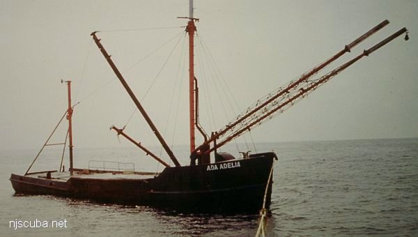
- Type:
- artificial reef, trawler, USA
- Built:
- 1866, Eastport ME USA
- Specs:
- ( 65 x 20 ft )
- Sponsor:
- Adelia Inc. & Andy Applegate
- Sunk:
- Friday Oct 11, 1991 - Atlantic City Artificial Reef
- GPS:
- 39°15.500' -74°13.880'
- Depth:
- 85 ft
More: Ada Adelia ...