Sandy Hook Artificial Reef
1.6 nautical miles off Sea Bright, 1.76 sq miles
Depth: 40-60 ft [download]
More: Sandy Hook Artificial Reef ...
Sandy Hook Artificial Reef
1.6 nautical miles off Sea Bright, 1.76 sq miles
Depth: 40-60 ft [download]
More: Sandy Hook Artificial Reef ...
Sea Girt Artificial Reef
3.6 Nautical Miles off Sea Girt, 1.33 sq miles
Depth: 60-75 ft [download]
More: Sea Girt Artificial Reef ...
Shark River Artificial Reef
15.6 Nautical Miles off Manasquan, 0.83 sq miles
Depth: 120-140 ft [download]
More: Shark River Artificial Reef ...
Shinnecock Artificial Reef (historical)
( 40.80139, -72.47293 )
2.0 Nautical miles south of Shinnecock Inlet, 0.55 sq miles
Depth: 76 - 84 ft
More: Shinnecock Artificial Reef ...
16-Fathom Artificial Reef
13 nautical miles southwest of Fire Island Inlet, 1.33 sq miles
Depth: 85 to 103 feet
More: Sixteen Fathom Artificial Reef ...
Smithtown Artificial Reef
1.6 nautical miles northwest of Stony Brook Harbor, 0.05 sq miles
Depth: 30 - 40 ft
More: Smithtown Artificial Reef ...
Townsend's Inlet Artificial Reef
3.8 nm offshore, 0.69 sq miles
Depth: 50-65 ft [download]
More: Townsend's Inlet Artificial Reef ...
12-Mile Artificial Reef
12.0 nautical miles from Moriches and Shinnecock Inlets, 1.33 sq miles
Depth: 123 - 143 ft
More: Twelve-Mile Artificial Reef ...
Wildwood Artificial Reef
4.5 Nautical Miles off Wildwood, 2.99 sq miles
Depth: 40-65 ft [download]
More: Wildwood Artificial Reef ...
900 yards east of the Robert Moses Fixed Bridge, 0.01 sq miles
Depth: 25 - 40 ft
More: Yellowbar Artificial Reef ...
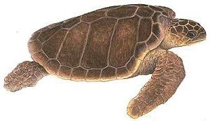
Caretta caretta
Size: to 40" ( shell ) and 300 lbs.
Habitat: oceanic
Notes: Loggerhead turtles feed primarily upon bottom-dwelling invertebrates. Compared to Greens, Loggerheads have proportionately larger heads and jaws. They are the most common sea turtles in our waters and the only type that is not endangered.
More: Loggerhead Sea Turtle ...