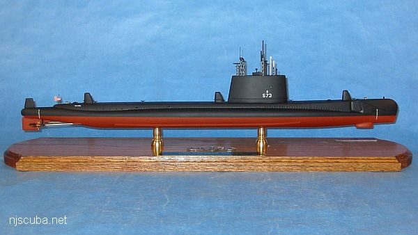
USS Salmon SSR-573
- Type:
- shipwreck, Sailfish class submarine, U.S. Navy
- Built:
- 1956, Portsmouth Naval Shipyard, Portsmouth NH, USA
- Specs:
- ( 350 x 25 ft ) 2530 tons, no crew
- Sunk:
- Saturday June 5, 1993 - "artificial reef"
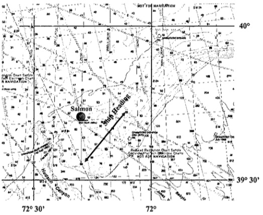
- GPS:
- 39°42.2' -72°18.2' (US Navy 2004)
- Depth:
- 360 ft

A radar picket was a vessel that stayed out in front of the fleet, to warn of incoming air attacks. You might imagine this is a very dangerous job - eliminating these early-warning ships was a high priority for the other side. During World War II, the task of radar picket fell to destroyers, and more than a few were lost to Kamikaze attacks by the Japanese. The Navy reasoned that a submarine would be able to dive away from danger, and so a number of submarines were converted to the task, and a few, like the Salmon, were purpose-built. How well they would work out was never really determined, as rapid improvements in electronics and carrier aircraft resulted in aerial radar platforms that were completely superior. The picket subs "SSR"s were stripped of their radars and converted to attack boats "SS"s. Salmon served in this role for many years.
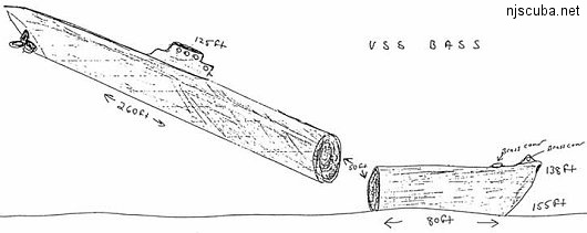
Salmon was decommissioned and stricken from the Naval Vessel Register on 1 October 1977. In 1992 Salmon was converted to a shallow water sonar target and moored off the bottom adjacent to the Hudson Canyon, on June 5, 1993. From the Navy's 2004 report: "The Ex-USS Salmon was air-filled when sunk in the early 1990s, but recent surveys indicate that it may now be partially filled." In other words, it probably sank to the bottom.
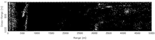
The Navy was working on side-scan sonar technology for detecting underwater mines. Look at the range on that plot - 5000 meters - about 3 miles! They got ranges out to 8000 meters, almost 5 miles. That's incredible, with 1990s technology. You can read the whole report here ( PDF, pretty dry stuff. )
Deep Sea Dive Sites, Dive Sites, Submarines,
Deep Sea Chart (pan right for more)
- Four Daughters
- 44097 Weather Buoy
- 44402 Weather Buoy
- USS Akron
- Andrea Doria
- Atlantic Princess
- Azua
- USS Baldwin
- Bidevind
- Brian C
- Carolina
- Catamount
- Cayru
- Champion
- USS Cherokee
- Coimbra
- Corvallis
- Deepwater Dump
- Durley Chine
- Edward H Cole
- Galimore's Cayru
- Lady Gertrude
- Herbert Parker
- Thomas Hebert
- Hvoslef
- Isabel B Wiley
- India Arrow
- USS Jacob Jones
- Jacob M Haskell
- Lady Mary
- Lillian
- Maiden Creek
- Miraflores
- Misty Blue
- Montgomery
- USS Moonstone
- USS Murphy
- Northern Pacific
- Norness
- Pan Pennsylvania
- Republic
- Rio Tercero
- RP Resor
- Southern Lillian
- USS S-5
- USS Salmon
- SC-209
- Sebastian
- Shookus
- Sommerstad
- USS Spikefish
- Suffolk
- Texas Tower
- Texel
- U-550
- U-869
- Varanger
- West Wreck
- Wily Fox
- Winneconne
More: Deep Sea Dive Sites ...
Questions or Inquiries?
Just want to say Hello? Sign the .