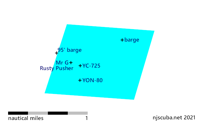
FE312SS/88 -- OPR-C121-WH-88; WHILE SEARCHING FOR AWOIS ITEM 1634, TWO SIDE-SCAN SONAR CONTACTS WERE LOCATED AND IDENTIFIED AS WRECKAGE (ALSO REFERENCE ITEM 7508); AN OBSTRUCTION (SSS CONTACT NO. 379.6S) WAS FOUND; DIVER LEAST DEPTH OF 36 FT. IN PRESENT SURVEY DEPTHS OF 38 FT.; REMAINS OF A PORTION OF A KEEL OF A METAL HULLED VESSEL; VESSEL WAS LYING INVERTED WITH THE KEEL EXPOSED; PORTION OF MIDSECTION OF VESSEL WAS VISIBLE; ENTIRE STRUCTURE WAS COATED WITH ANTI-FOULING PAINT; 45 FT. WIDE AT THE BEAM, 37 FT. AT THE NORTHERN END AND 18 FT. LONG; SOUTHERN END OF SITE WAS BENT AND TWISTED; HULL STOOD APPROXIMATELY 3 FT. OFF THE BOTTOM AT THE NORTHERN END, AND A SAND SCOUR AT THE SOUTHERN END EXPOSED APPROXIMATELY 6-8 FT. OF THE WRECK (3-4 FT. BELOW THE SURROUNDING BOTTOM). (ENTERED MSM 10/89)
More: u12 - AWOIS 7509 ...
Questions or Inquiries?
Just want to say Hello? Sign the .