Manasquan River Inlet
Manasquan Inlet
- Type:
- tidal river inlet with stone jetties or bulkheads on both sides
- Depth:
- 30 ft
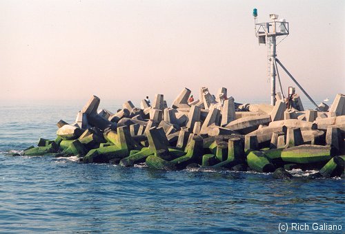
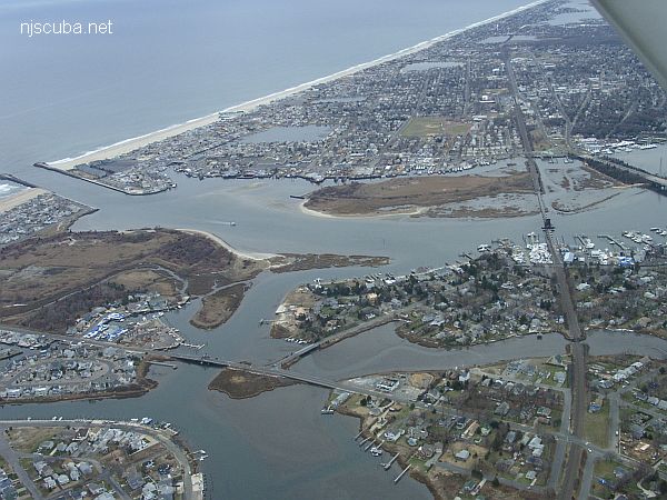
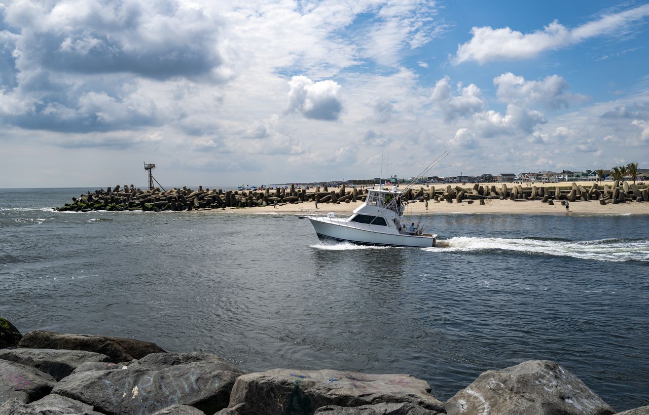
This inlet has a long slightly L-shaped jetty on the north side and a longer straight jetty on the south side. Both jetties are made of large stones and concrete, and the ends are built out of man-made concrete "jacks", shaped like an H with a 90-degree twist in the middle.
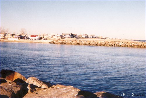
Both sides have an easy climb up or down the rocks where the bulkhead meets the jetty, however, the jetties themselves are steep and tall, and would probably be impossible to climb in full scuba. An alternative is to swim around the point and come up on the beach, but it is a very long swim, and I would recommend against it unless you are a very strong swimmer. If you think about the restrictions above, you'll realize that it is completely illegal to cross from one side of the river to the other. Boat traffic in this inlet can be extremely heavy.
The "jacks" at the end of each jetty are extremely dangerous in a surge, and confusing to navigate around. Several people have died when waves pinned them into the large pockets between the jacks at this point. Avoid this area unless you are very experienced in this sort of diving, and the sea is absolutely calm.
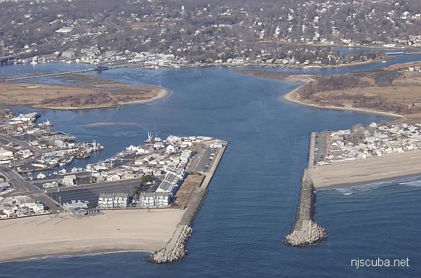
Point Pleasant on the left /south
Manasquan on the right / north
The only times I ever dove this river, the visibility was terrible, literally zero near the end of the north jetty. The bottom is exactly the same as at the Railroad Bridge, with more sandy areas farther away from the jetties. There were huge spider crabs, big fluke in the sand, and eels, but along the whole length of the jetty, I saw not one lobster. ( Other people tell me there are many on the south side of the inlet. ) the area under the fishing bulkhead is supposed to be a treasure trove of lost articles, but there are almost always fishermen there.
Parking is free in Manasquan on the north side, metered in Point Pleasant on the south, and can be hard to find close by on both sides. On the north side, there are also showers by the beach and a food stand.

Tip: if conditions here turn out to be too rough for diving from the south side, you may still be able to dive the nearby Railroad Bridge, where the tide is about 10 minutes later. This is not true for the north side, since the north and south sides of the inlet are several miles apart by road.
All in all, I recommend the Shark River inlet over this one, especially for less experienced divers. However, I am told that conditions here can be a lot better, and I have seen pictures to prove it, so I'm not writing this one off yet.
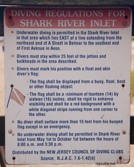
Restrictions:
- No time limits posted.
- Diving permitted only within 50 ft of jetties.
- Diving not permitted west of Ocean Ave / First Ave. Flag required.
- Spear fishing is illegal on the north (Manasquan) side of the inlet.
- Point Pleasant ( south Side ) has strong ( and kooky ) laws against disrobing in public, including wetsuits, although they are not usually enforced.
These restrictions are clearly posted on both sides of the inlet; also see Regulations.
Since this is a tidal river, you must dive at slack water. If you've never dived a local river or inlet before, you may want to look at the page on Local Diving Conditions.


Dive Sites, Manasquan Dive Sites, New Jersey Dive Sites,
Manasquan Chart
- Barge #10
- 120 Wreck
- 3 Sisters
- Ambrose Buoy
- A Street - Shark River
- Across
- Adele
- Ajace
- Alex Mac
- Allenhurst Jetty
- Anastasia
- Antioch
- Arnoff
- Arundo
- Asfalto
- Aurora
- Ayuruoca
- BA Wreck
- Shark River - Back Bay
- Balaena
- Bald Eagle
- Barnegat Inlet
- BD1738
- USS Benson
- Beth Dee Bob
- Blue Boy
- Bonanza
- Brick barge
- Bronx Queen
- Brunette
- Cecilia M Dunlap
- Cornelius Grinnell
- Catherine Jackson
- Chauncy Jerome
- Caddo
- Cadet
- Capt Smitty
- Catamount
- Charlemagne Tower
- Chaparra
- Chesapeake
- Choapa
- clam boat
- Continent
- crane barge
- Creole
- Daghestan
- Delaware
- drydock
- Dryland
- dump
- Duncan
- Edmund Phinney
- Elberon Rocks
- Emerald / USS Hibiscus
- Eureka
- Francis A Perkins
- William R Farrell
- FF Clain
- Finance
- Fort Victoria
- Gassoon
- German
- Lady Gertrude
- GL78
- Glen II
- Glory Wreck
- I.P. Goulandris
- Granite Wreck
- Great Isaac
- Gulftrade (stern)
- Gulftrade (bow)
- Gypsy
- Horseshoe Cove
- Alexander Hamilton
- Hankins (Big)
- Hankins (Offshore)
- Hankins 3
- Happy Days
- Cornelius Hargraves
- Harry Rush
- Harvey's Schooner
- Thomas Hebert
- Ida K
- Immaculata
- Inshore barge/tug
- Irene/Truro
- Irma C
- John Minturn
- Jack I
- Joan La Rie III
- Klondike Rocks
- Lizzie H. Brayton
- Lana Carol
- Larsen
- Lavallette Wreck
- Leon Walter
- Lillian
- Lizzie D
- Long Branch locomotives
- Logwood
- H.W. Long
- Macedonia
- Mahogany
- Malta
- Manasquan Inlet
- Marion
- Maurice Tracy
- Mediator
- Meta
- Middle Barge
- Mistletoe
- R.C. Mohawk
- Mohawk
- Manasquan Wreck
- Nautilus
- Navesink River
- Northeast Sailor
- New Reef
- New Deal
- New Era
- NW Barges
- Olsen
- HMS Pentland Firth
- Park City
- Peerless
- Persephone
- Long Branch Pier Rubble
- Pinta
- Pliny
- Plymouth
- Pocopson
- Remedios Pascual
- Ruth Shaw
- Ramos
- Ranger
- Reliable
- Relief Lightship
- Rickseckers
- Ridge Schooner
- Riggy
- Rjukan
- Rockaway Belle
- Roy's barge
- RP Resor
- Manasquan River Railroad Bridge
- Rudder Wreck - Pocono
- Rump
- Rusland / Adonis
- Scotland Buoy
- San Saba
- Sandy Hook Pilot Boat
- SC-60
- Sea Girt Inlet
- Sea Girt Wreck
- Sea Hag
- Seaside Crane Barge
- Shark River Inlet
- Shrewsbury Rocks
- Simala
- Spring Lake Sailor
- Steel Wreck
- Stolt Dagali
- Sumner
- Southwest Mohawk
- Sylvanus
- Tampa III
- Thurmond
- Tolten
- Train Wheel
- Troop Carrier
- USS Turner
- AWOIS 8087
- AWOIS 8097
- u11
- AWOIS 7509
- AWOIS 7932
- AWOIS 9768
- AWOIS 12966/11422
- AWOIS 1609
- AWOIS 8084
- AWOIS 7940
- AWOIS 7938
- AWOIS 8076
- AWOIS 4600
- AWOIS 8075
- Valerie E
- Vega
- Vivian
- Vizcaya
- Warrior
- Western World
- Edward W Winslow
- Yankee (G+D)
- Yellow Flag
- ZPG-3W
More: Manasquan Dive Sites Chart ...
The Manasquan River is overall not as nice a place to dive as the Shark River. The currents are stronger, the water never seems as clean, and the bottom is silty wherever it is not covered with mussels. The inlet jetties can be downright dangerous, and the boat traffic in the channel there is often very heavy. Off the north jetty is the so-called "Manasquan Wreck", but this is a long swim from shore and probably best approached with a boat.
More: Manasquan River ...
- Type:
- inland tidal river
- Depth:
- 20 ft, mostly a lot shallower
This spot is upstream on the Manasquan River. The diving area is rather small and not very deep. Visibility tends to be poor, and this is worsened whenever an O/W training class is in session, which is often. Also, the current under the bridge becomes very strong, so slack water is essential. For a long time, a dredge barge has been anchored in the channel, but otherwise, there is no boat traffic.
More: Manasquan River Railroad Bridge ...

- Type:
- shipwreck, sailing ship, USA
- Built:
- 1816, New York NY, USA
- Specs:
- 382 tons
- Sunk:
- Saturday April 24, 1824
ran aground in a fog - no casualties - Depth:
- 30 ft
More: Manasquan Wreck - Amity ...
N.J. Shore inlet to be surveyed after large sandbar forms
By Nicolas Fernandes
NJ Advance Media for NJ.com
Aug. 17, 2022
Sand piling up in Manasquan Inlet
Andrew Mills | NJ Advance Media for NJ.com
The Army Corps of Engineers will visit the Manasquan Inlet next week to survey a large sandbar that has formed in the waterway, U.S. Rep. Chris Smith, R-4th Dist., said Wednesday.
Sands at the inlet have shifted before, but the low-tide sandbar is larger than anything seen there before, the congressman said.
"We are gravely concerned that it will pose a serious hazard to navigation," Smith said.
More: Manasquan Inlet Filling In ...

Questions or Inquiries?
Just want to say Hello? Sign the .