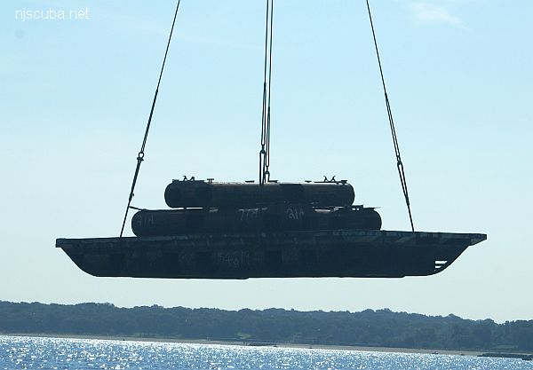
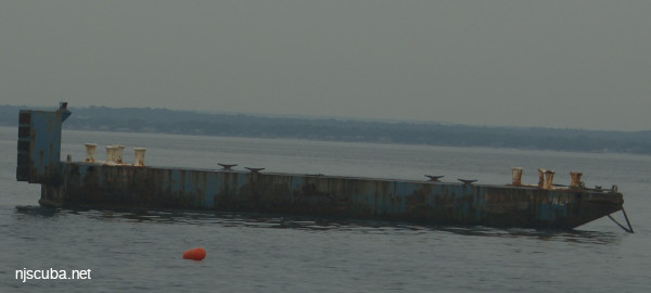
barges - Matinecock Artificial Reef
- Type:
- artificial reef, barges
- Depth:
- 30 - 40 ft
| Name | Description | Sunk | GPS |
| 46 ft steel | Thursday Aug 22, 2019 |
40°54.604' -73°37.477' |
|
| 40 ft steel | Thursday July 25, 2024 |
40°54.613' -73°37.394' |

Artificial Reef Sites, Artificial Reefs, Barges, Matinecock Artificial Reef, New York Artificial Reef Sites, New York Artificial Reefs,
Matinecock Artificial Reef
More: Matinecock Artificial Reef ...
Long Island Sound - West Chart
- 44039 Weather Buoy
- Amsterdam
- Atlantic
- Barataria
- USS Bass
- Bayville barge
- Black Point
- Celtic/Cape Race
- Condor
- HMS Culloden
- Defender
- John A. Downs
- Essex
- Gwendoline Steers
- USS G-1
- USS G-2
- Grecian
- Horton's Point / Commodore
- Huntington Artificial Reef
- HMS Hussar
- USS L-8
- Larchmont
- Lexington
- Lightburne
- Malden
- Matinecock Artificial Reef
- Mattituck Inlet
- Mattituck Artificial Reef
- Montauk Inlet
- Mount Sinai Harbor
- Myronus
- USS Ohio
- Olinda
- Poling Bros #2
- Port Jefferson Artificial Reef
- Port Jefferson Inlet
- Shoreham Nuclear Power Plant
- Smithtown Artificial Reef
- Snug Harbor
- Thames
- Thelma Phoebe
- U-853
- Volund
- Delaware River Water Gap
Long Island Sound - East Chart
- 44039 Weather Buoy
- Amsterdam
- Atlantic
- Barataria
- USS Bass
- Bayville barge
- Black Point
- Celtic/Cape Race
- Condor
- HMS Culloden
- Defender
- John A. Downs
- Essex
- Gwendoline Steers
- USS G-1
- USS G-2
- Grecian
- Horton's Point / Commodore
- Huntington Artificial Reef
- USS L-8
- Larchmont
- Lexington
- Lightburne
- Malden
- Matinecock Artificial Reef
- Mattituck Inlet
- Mattituck Artificial Reef
- Montauk Inlet
- Mount Sinai Harbor
- Myronus
- USS Ohio
- Olinda
- Poling Bros #2
- Port Jefferson Artificial Reef
- Port Jefferson Inlet
- Shoreham Nuclear Power Plant
- Smithtown Artificial Reef
- Snug Harbor
- Thames
- Thelma Phoebe
- U-853
- Volund
- Delaware River Water Gap
Long Island Sound averages 60 ft in depth, with the greatest depth of over 300 ft at the eastern end. Tidal effects are strongest at the narrow western end, where all the inrushing water flow piles up and makes tidal variations of up to 7 ft. Strong tidal currents are also prevalent, and visibility tends to be poorer than the open ocean, especially at depth.
More: Long Island Sound Dive Sites Chart ...
Long Island - Central Chart
- 3 Sisters
- 3/4 Tug
- 44069 Weather Buoy
- 59-Pounder
- Acara
- Across
- Arnoff
- Arundo
- Asfalto
- Ayuruoca
- BA Wreck
- Balaena
- Bald Eagle
- USS Benson
- Beth Dee Bob
- Blue Boy
- Burnside
- Catamount
- Choapa
- coal (Lido)
- Coastwise
- Continent
- Dodger
- Dragger
- Drumelzier
- drydock
- Edwin Duke / Stone Barge
- dump
- East Rockaway Inlet
- Eureka
- Fire Island Inlet
- Gate City
- Gluckauf
- I.P. Goulandris
- Gypsy
- Happy Days
- Harvey's Schooner
- Howard
- Hylton Castle
- Iberia
- Immaculata
- Irma C
- Jones Inlet
- Jones Tug
- Kenosha
- Kismet Artificial Reef
- Larsen
- Linda
- Lizzie D
- Margaret
- R.C. Mohawk
- Moriches Inlet
- Old Yankee
- Oregon
- Pipe Barge
- Ponquogue Bridge
- Ruth Shaw
- Reggie
- Rockaway Belle
- Roda
- USS San Diego
- SC-209
- Sea Wolf
- Shinnecock Inlet
- Sommerstad
- Steel Wreck
- Stolt Dagali
- USS Tarantula
- Train Wheel
- Valerie E
- Wolcott
- Yankee (G+D)
- Yellowbar Artificial Reef
More: Long Island Central Dive Sites Chart ...
Questions or Inquiries?
Just want to say Hello? Sign the .