Bottom Composition
With rare exceptions, scuba diving is a bottom-fixated activity. In the region covered in this website, one may encounter many different bottom types, from rocky pinnacles around Block Island to white sands off Cape May to mud and oyster beds in any estuary. This variation is far greater and more interesting than is found in the tropics. Here is some explanation of what bottom compositions are found where and why:
Loose Sediments - Silt, Mud, Sand, Pebbles
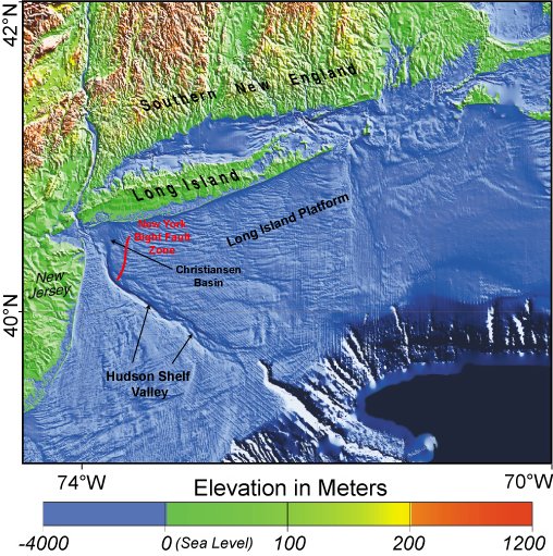
New Jersey and Long Island are bordered to seaward by a huge underwater plain known as the New York Bight. Continental bedrock, exposed as the Appalachian Mountains, slopes steadily downward to the abyss. However, this is capped with a wedge-shaped layer of sediments which begins thinly on land at the foot of the mountains and increases to a thickness of several miles near the edge of the continental shelf, where it drops off steeply. This layer is composed mainly of clay and sandstone, eroded from the continental interior and brought down to the sea by rivers, mainly the Hudson, but also the Raritan and Delaware.
This relatively hard clay and sandstone base is covered with a layer of looser sediments - sand, mud, silt, and pebbles. These are also derived from sources inland. The constant action of the sea breaks down, sorts, and redistributes these sediments. Wave action on the beaches works sand grains against each other until all but the hardest are literally ground to dust. In our area, this results in beach sands and near-shore sediments composed almost entirely of rounded quartz grains.
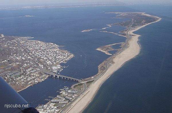
Beach sand is transported by wave action. The dominant wave direction in the region is from the southeast. When these waves strike the beach at an angle, they create a "longshore current" which flows generally south to north along New Jersey, and east to west along Long Island. This carries sediments towards New York Harbor, where they are deposited, both in the Harbor and as sand spits such as Sandy Hook and Breezy Point. Locally, more sediments are added by the Hudson, Raritan, and Navesink Rivers. Tidal flows redistribute some of this sediment back out into the bight, but much of it must be dredged out to maintain a useful depth in the harbor.
Large winter waves tend to draw sand off the beaches to locations just past the surf zone. This sand is largely restored by smaller summer waves. Lately, sand has also been artificially added to the beaches to compensate for rising sea levels and protect waterfront communities. This beach replenishment is an economically sound policy that has at most minor ecological impact. ( Clams and beach bugs have survived hurricanes for millennia! )
In addition to the regular ebb and flow of the tides, and the constant discharge of the rivers, bottom sediments are also re-arranged by storms. A single major winter storm can move more sediment than an entire year of longshore transport. Both Shinnecock and Moriches inlets were created literally overnight by ( different ) hurricanes. In the same way, Sandy Hook will someday be cut off from the mainland, as it originally was.
Water currents and waves sort bottom sediments by grain size. The faster a flow, the larger a particle it can carry. Therefore, in the areas of fastest flow, only the largest particles will remain, all the rest having been washed away. Thus, in areas of very strong tidal flow, such as in the approaches to New York Harbor, off Sandy Hook and Rockaway, the bottom tends to be largely pea gravel. This gives way further out to coarse sand, and then finer and finer sands and muds in areas of relative calm. Higher areas also tend to get scoured clean, as currents are accelerated over and around obstructions.
Runoff from the land tends to be very silty, with much organic matter and suspended clays. Especially after a storm, brown river water can be seen flowing out into the blue ocean for miles. Tiny silt particles suspended in freshwater river flows tend to clump together ( or flocculate ) when exposed to seawater. They then settle out of the water column, resulting in muddy fans near the mouths of rivers, as well as in bays and inlets. The Hudson River is so huge that its flow carries many miles out to sea and fills the Mud Hole with silt.
River channels also tend to be scoured clean by the flow, while nearer the banks, muddy conditions may prevail. However, most of the diveable rivers and inlets in the area have been heavily modified by man, with bulkheads, bridges, and stone jetties channeling and accelerating the flow. There is hardly anything natural about a river like this, even though the diving conditions are probably actually improved. In places, many river bottoms are covered with dense beds of mussels. These have replaced the oysters that were wiped out by pollution, but are slowly making a comeback.
Natural Rock Formations
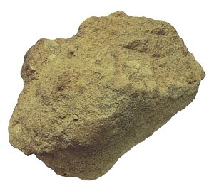
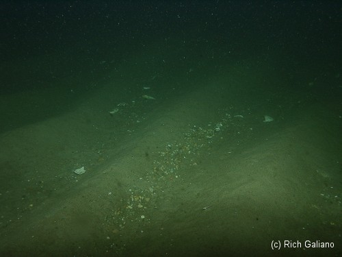
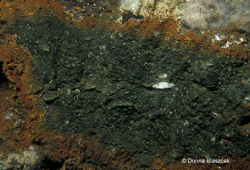
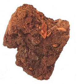
All along the coast, there are natural rock formations in the otherwise sandy or muddy bottom of our underwater environment. The Shrewsbury Rocks are the largest and most well-known of these; the Klondike Rock further south are similar but lower. Many others are not depicted here but are listed as "lumps" or 'ridges" on fishing charts. A very large underwater rock formation occurs off Watch Hill Long Island. Most of these are outcroppings of the local Greensand ( shown at right, ) although further south and offshore they are more likely to be clay.
The Artificial Reef Program has greatly augmented the natural hard bottom of the region with millions of tons of dumped rock from construction and dredging projects. The largest concentrations are in the Sandy Hook Reef and the Shark River Reef.
Most of these natural formations are low, seldom rising more than 10 feet off the bottom, and riddled with caves and overhangs. They are a magnet for marine life of all sorts and are excellent places for spearfishing and lobstering. Before man added shipwrecks, jetties, and artificial reefs to the marine environment, these sparse rock outcroppings were all the hard structure and habitat for marine life that existed in the otherwise featureless sandy plain.
Greensand is a variety of sandstone which forms only in shallow marine environments, and dates to the Cretaceous period ( think dinosaurs. ) It is a common bedrock layer across North America. It is usually imperfectly consolidated, consisting largely of glauconite - ((K, Na)(Fe3+, Al, Mg)2(Si, Al)4O10(OH)2) - a greenish-black to blue-green silicate of iron and potash, mixed with sand and a trace of phosphate of lime. It is the glauconite that gives the stone its characteristic greenish color.
Because of its potash and phosphate content, ground-up Greensand Marl was once a useful agricultural fertilizer and soil conditioner and was widely mined. 'Marling' of soil tends to lighten it, correct acidity, and promote nitrification. Greensand is recommended by organic gardeners as a mulch, top dressing, and soil- conditioning additive for both potted plants and vegetable gardens. The slow-release rate of nutrients minimizes the possibility of plant damage by fertilizer "burn" while the mineral's moisture retention aids soil conditioning.
Early in the 1900s, glauconite was recognized as having chemical exchange properties in water solutions, which led to its use as a water softener. In the 1830s, the marl pits of New Jersey yielded the first complete dinosaur skeletons in the world. The towns of Marlton and Marlboro are named for the marl pits there.
- Reef Habitats in the Mid-Atlantic Bight
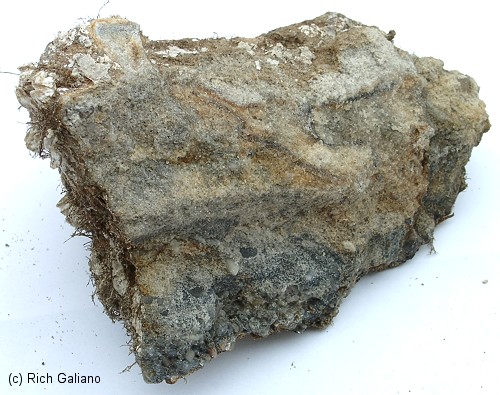
Clay & Shale
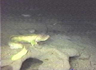
bank riddled with Tilefish tunnels
off the Georges Bank.
In places where currents have scoured away the loose upper bottom sediments, you may find the underlying clay or shale. One such place is the Algol, where the tidal currents are accelerated around the huge hull and have scoured a hole down through the loose sand to the clay beneath. The Algol sinks a little deeper every year because of this. Far offshore, deepwater Tilefish dig homes into the steep clay faces of the underwater canyons, while lobsters may burrow into shallower environments.
Clay is a common name for a number of fine-grained, earthy materials that become plastic when wet. Chemically, clays are hydrous aluminum silicates, ordinarily containing impurities, e.g., potassium, sodium, calcium, magnesium, or iron, in small amounts.
Properties and Classification
Properties of the clays include plasticity, shrinkage under firing and under air drying, fineness of grain, color after firing, hardness, cohesion, and capacity of the surface to take decoration. On the basis of such qualities clays are variously divided into classes or groups; products are generally made from mixtures of clays and other substances. The purest clays are the china clays and kaolins. "Ball clay" is a name for a group of plastic, refractory ( high-temperature ) clays used with other clays to improve their plasticity and to increase their strength. Bentonites are clays composed of very fine particles derived usually from volcanic ash. They are composed chiefly of the hydrous magnesium-calcium-aluminum silicate called montmorillonite.
Individual clay particles are always smaller than 0.004 mm. Clays often form colloidal suspensions when immersed in water, but the clay particles flocculate ( clump ) and settle quickly in saline water. Clays are easily molded into a form that they retain when dry, and they become hard and lose their plasticity when subjected to heat.
Formation
Clays are divided into two classes: residual clay, found in the place of origin, and transported clay, also known as sedimentary clay, removed from the place of origin by an agent of erosion and deposited in a new and possibly distant position. Residual clays are most commonly formed by surface weathering, which gives rise to clay in three ways - by the chemical decomposition of rocks, such as granite, containing silica and alumina; by the solution of rocks, such as limestone, containing clayey impurities, which, being insoluble, are deposited as clay; and by the disintegration and solution of shale. One of the commonest processes of clay formation is the chemical decomposition of feldspar.
Clay consists of a sheet of interconnected silicates combined with a second sheet-like grouping of metallic atoms, oxygen, and hydroxyl, forming a two-layer mineral such as kaolinite. Sometimes the latter sheetlike structure is found sandwiched between two silica sheets, forming a three-layer mineral such as vermiculite. In the lithification process, compacted clay layers can be transformed into shale. Under the intense heat and pressure that may develop in the layers, the shale can be metamorphosed into slate.
Uses
From prehistoric times, clay has been indispensable in architecture, industry, and agriculture. As a building material, it is used in the form of brick, either sun-dried ( adobe ) or fired. Clays are also of great industrial importance, e.g., in the manufacture of tile for wall and floor coverings, of porcelain, china, and earthenware, and of pipe for drainage and sewage. Highly absorbent, bentonite is much used in foundry work for facing the molds and preparing the molding sands for casting metals. The less absorbent bentonites are used chiefly in the oil industry, e.g., as filtering and deodorizing agents in the refining of petroleum and, mixed with other materials, as drilling muds to protect the cutting bit while drilling. Other uses are in the making of fillers, sizings, and dressings in construction, in clarifying water and wine, in purifying sewage, and in the paper, ceramics, plastics, and rubber industries.
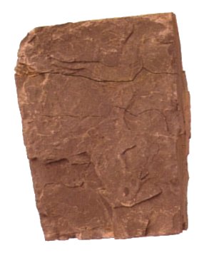
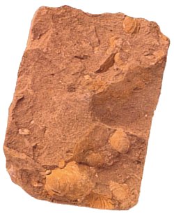
Shale is a sedimentary rock formed by the consolidation of mud or clay, having the property of splitting into thin layers parallel to its bedding planes. Shale tends to be fissile, i.e., it tends to split along planar surfaces between the layers of stratified rock. Shales comprise an estimated 55% of all sedimentary rocks.
The composition of shale varies widely. Shales with very high silica content may have been formed when large quantities of diatoms and volcanic ash were present in the original sediment. Large numbers of fossils in shales may give them a high calcium content; such shales may grade into limestones.
Shales that contain a large percentage of alumina are used as a source of that mineral in the manufacture of cement. Shales containing abundant carbonaceous matter grade into bituminous coal. Oil shales are widely distributed in the western United States and may be a future source of petroleum.
Cut walls of the native red "New Brunswick" shale may be seen along Route 18.
Peat
Peat is a soil material consisting of partially decomposed organic matter; found in swamps and bogs in various parts of the temperate zone. It is formed by the slow decay of successive layers of aquatic and semiaquatic plants, e.g., sedges, reeds, rushes, and mosses. One of the principal types of peat is moss peat, derived primarily from sphagnum moss; it is used in agriculture as poultry and stable litters as well as a mulch, a soil conditioner, and an acidifying agent; it is also used in industry as an insulating material.
Another type of peat is fuel peat, which is most widely used in regions where coal and wood are scarce, e.g., Ireland, Scandinavia, and parts of Russia. Peat is the earliest stage of transition from compressed plant growth to the formation of coal. Large deposits of peat in the United States are found in Michigan, California, and the Florida Everglades.
Peat is commonly found along the local shorelines in bays and estuaries. Thick layers of it often underlie the reeds and grasses in marshy areas. At the water's edge, the peat may be found crumbling down onto the sand due to wave action.
Offshore Dumping Grounds
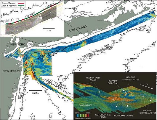
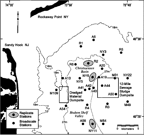
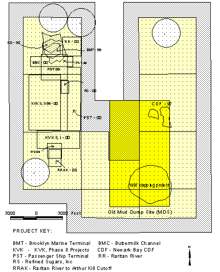
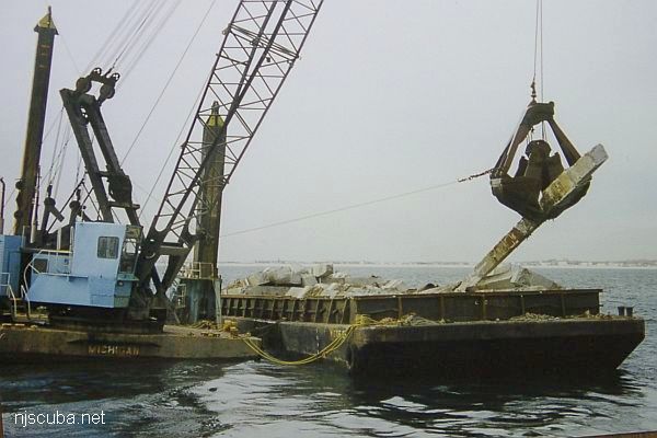
For most of mankind's history, the world's oceans have been used as refuse dumps. Everything from sewage to everyday trash to medical, industrial, and chemical waste has been disposed of in the ocean, or in rivers that flow out to the ocean. In the vicinity of a major urban area like New York, you can bet there has been a lot of waste and dredge dumping, and much of it at sites that are alarmingly close to shore. All ocean dumping was finally banned by the EPA in 1988 after some massive fish kills, but not before many seafloor habitats were contaminated if not outright destroyed. The two major ocean dumping sites that have served the New York area since the mid-1800s are the 12 Mile Dumping Ground and the Mud Dump. Old dumpsites are marked on the charts as yellow areas or brown crosses.
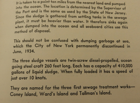
The 12 Mile Dumping Ground was until recently the main repository for all of New York City's sewage waste, over six million tons annually. As such, this is a good area to avoid, both for fishermen and divers. The entire area is contaminated with toxic sludge and heavy metals, which forms a layer of poisonous black muck over everything. The 12 Mile dump was closed in 1987, after 63 years of operation. The average depth is about 100 feet. The area is slowly recovering, but I would not eat any fish or shellfish caught there, ever.
"The 12 Mile Sludge Dump was, and is, a toxic area. Although all remnants of biodegradable matter have long since been dissolved by the forgiving sea, the toxic metals contained within it are no doubt still present in the area's sediments, although I don't know to what extent. I have dived on the R.C. Mohawk 15 years ago and 5 years ago, and the positive change in the amount of sea life on the site was phenomenal."

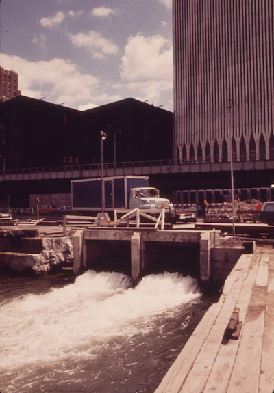
If you think that is bad, this is the old World Trade Center, dumping all of its untreated wastewater directly into the Hudson River. Seems the Port Authority ( also in charge of sanitation ) gave themselves a sweetheart deal when they built the towers. I have personally witnessed the bay waters become much cleaner since the tragedy of 9/11. I hope the new WTC was designed with sewage treatment facilities.
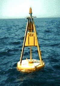
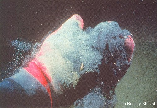
The Mud Buoy ( right ) marks the site of the 2.2 square-mile Mud Dump ( officially, the New York Bight Dredged Material Disposal Site. ) For over a century this was the disposal site for sediments dredged from New York Harbor and surrounding areas. The area is contaminated with PCBs, dioxin, petrochemicals, and lord-knows-what-else that accumulated on the floor of the harbor and was then dug out. So much mud has been dumped here - over 200 million cubic yards - that it actually forms a mound above the surrounding bottom. However, not all of the harbor dredgings actually ended up inside the dumpsite, due to navigational errors and natural dispersal by the sea, so that the contaminated area is much larger than indicated. The average depth in this vicinity is 60-70 feet.
The Mud Dump site was officially closed in 1996, but was re-opened in 1997 by the Army Corps of Engineers as the greatly expanded "Historic Area Remediation Site" or HARS ( 15.7 square nautical miles, outlined in yellow on the chart. ) Different sections of the HARS are slated for different types and amounts of material, and small no-dumping zones are defined around several known shipwrecks, ostensibly to avoid burying them. The dredge material that is being dumped into the HARS site is supposedly cleaner than what was previously placed there and thus will form a "remedial cap" about one meter thick over the old pollutants.
Seems to me it's pretty much the same stuff they have been dumping there all along, and they just had no other place to put it. However, the new dump is much bigger than the old Mud Dump and should allow them to go on dumping New York dredge spoils forever, and all under the guise of cleaning up the old site. Closing one dump and then opening a bigger one in its place might strike you as duplicitous ( thanks, Al Gore. ) However, in the bigger scheme of things, this was inevitable, as letting New York Harbor fill up with silt and become unusable is simply not an option, and all that mud has to go somewhere. Hopefully, the new material really is cleaner, but in any case, you don't want to go bottom fishing around the Mud Buoy.
"The cap material that is now being used is coming from the very same channels and shipping berths as before. Although the stuff being used as cap material today is polluted with the same chemicals as in the past, it is deemed to be not AS POLLUTED, and therefore is good enough for remediation purposes. This is just a veiled excuse to keep dumping; I have absolutely no doubt that in the future when the HARS is finally finished being capped there will be a big "discovery" that the site is still too dirty, and must be re-capped with future dredge spoils to clean up the present cap material - a never-ending cycle !"
The Cellar Dirt dump site lies just east of the Mud Dump ( not charted. ) "The Cellar Dirt dump was actually a good dumpsite, as it consisted of blasted rock from the NYC subway system creation, and construction debris from the early 1900s -- an unintentional precursor to today's artificial reefs. Loads of bottom fish on the many piles of remaining debris." the Sandy Hook Artificial Reef today performs the same function, but the material that is placed there and on other artificial reefs today is inspected and certified to be clean and environmentally safe prior to disposal. Sandy Hook Reef now receives most of the rock and rubble that would otherwise go into the Mud Dump or the HARS.
The Acid Grounds was a dumpsite for acid and alkaline wastes, which was closed in 1988. The average depth is 90-100 feet. "The Acid Dump was, as far as I know, used exclusively by National Lead Co. of South Amboy, when that firm existed on the Raritan River on the west side of the Driscoll (Parkway) Bridge. From what I have ever heard the acid was quickly neutralized by the seawater in a chemical reaction and never posed an environmental hazard other than the temporary stain it left after being dumped. Any residue that settled to the seafloor could have had negative effects, but after all this time, storms and Mother Nature have likely cleaned the seafloor at the site."
Further to the south, the Wood-burning dumpsite was a location where barge-loads of wooden timbers were taken, burned, and then the ashes were dumped. My guess is that the wood that was disposed of here was too contaminated with creosote and chemicals to be recycled or disposed of on-shore. One would expect ashes to float away on the currents, but any unburned materials would probably sink to the bottom, and it was not unheard of to have loads of wood dumped before they were completely burned.
The 106 Mile or Deepwater dump site received industrial waste and sewage until 1991. Since this site is almost 100 miles offshore, and several thousand feet deep, it is of little concern to divers. The Mud Hole has also been used as a dumping ground, most likely for just plain old garbage.
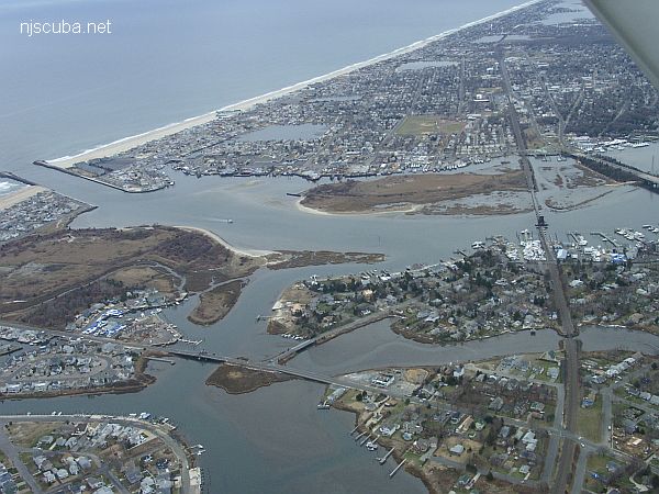
There are a number of minor dumping grounds located very close to shore between Rockaway and Fire Island inlets off Long Island, and one each off Manasquan and Shark River inlets in New Jersey. These are all probably reasonably clean sand dredgings from the nearby inlets, the byproduct of boat channel maintenance. In the Manasquan River, Gull Island is largely composed of the same kind of dredge spoils. Most of the sand that is dredged up from inlet maintenance in New Jersey now joins the beach sand that is pumped in from offshore in the beach replenishment program ( if it is clean enough ), a sort of reverse ocean dumping scheme. Dumpsites also existed in Long Island Sound.
If anyone would like to fill in or correct some of my guesswork above, please contact me.
Artificial Reefs
Many unnatural rock formations have been created by dredge-dumping activities, and more recently by artificial reef-building. Marine life takes to these new granite and concrete habitats just the same, and diving a man-made rock pile can be as interesting and productive as a natural one.