Vega
- Type:
- shipwreck, ferry, USA
- Built:
- 1925, Staten Island NY USA
- Specs:
- ( 75 x 40 ft ) 84 tons
- Sunk:
- Wednesday January 11, 1961
capsized under tow in storm, no casualties - GPS:
- 40°11.646' -73°56.787' (AWOIS 1990)
- Depth:
- 55 ft
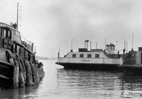
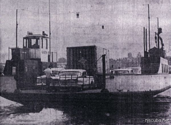
The Vega was a small diesel-electric automobile ferry that operated for the Port Richmond - Bayonne ferry service. She had a capacity of 10 cars and 50 passengers. After her last run in December of 1960, she was sold along with her two sisters, Altair and Deneb, to a firm in Jacksonville, Florida. While all three were under tow to their new owner, Vega's cable parted in heavy seas and she capsized. Altair and Deneb did not sink and were returned to Staten Island that day. The Vega's steel hull came to rest upside-down and is seldom visited today. Also known as "The Upside-down Ferry."
from AWOIS: 1514
FE333SS/89--OPR-C147-HE-89; CONTACT NO. 26; 50M RANGE SCALE SIDE-SCAN SONAR CONDUCTED OVER POSITION PROVIDED BY WHITING ON H10290/88; DIVERS LOCATED A RUSTED BUT INTACT CAPSIZED AUTOMOBILE AND PASSENGER FERRY MEASURING APPROXIMATELY 80 FT. LONG AND 40 FT. WIDE; LOCAL DIVERS IDENTIFIED AS THE VEGA; WRECK ROSE APPROXIMATELY 15 FT. OFF A SANDY BOTTOM; LEAST DEPTH OF 55 FT. BY LEADLINE. (UPDATED MSM 5/90)
Historical details courtesy of Jeff Cavorley
Vega was built in the Mariner's Harbor area of Staten Island in 1925, along with her sisters, Altair and Deneb. Directly after leaving the shipyard, the trio entered into service for the Bayonne-Port Richmond ferry line, where it remained in service until December of 1960. Within weeks, the Vega and her sisters were sold to a private firm in Jacksonville, Florida. Unfortunately the ferries never made it there. On January 11, 1961, while under tow along the Jersey Coast, the Vega sank in heavy seas. As for her sisters, Altair and Deneb survived the storm, returning to Staten Island. Today the Altair sits at the bottom of the Gulf, off of Alabama. Deneb was last seen on the Mexican Registry, but its status today is a question mark ...
Questions or Inquiries?
Just want to say Hello? Sign the .