Wind, Waves & Weather
Ocean waves are created by wind ( in unique instances, waves may also be created by earthquake, landslide, or other major disturbance, but that does not concern us here. ) The factors in the mechanics of wave creation are wind speed and duration, and fetch.
Fetch is the distance over which the wind acts on the water. The longer the fetch, the greater the wave-building action. Similarly, the greater the wind speed, the greater the wave-building action. Winds are named for the direction they blow from, not to. Therefore, a west wind blows out of the west, toward the east. Predicting wave heights based on wind conditions is even today extremely imprecise - the weather service still gets it wrong about half the time.
The Beaufort Scale of sea conditions was developed in 1806 by Rear-Admiral Sir Francis Beaufort of the English Royal Navy. It was originally based on eyeball observations but has been updated in recent times to be based instead on measured wind speeds. ( In 1806, instruments for accurately measuring wind speed had not yet been developed! ) Although it is purely empirical, the Beaufort Scale seems to be about as accurate as the most modern computer simulations in predicting wave heights.
To this day the scale is still useful in weather reporting, as it allows an experienced weather observer to report conditions as one of thirteen Force Levels, without the need of instruments or measurements. There is also a Beaufort Scale for use on land, which speaks of smoke, trees, and flags instead of waves, foam, and spray.
Beaufort Scale of Winds and Sea Conditions
| Force Level | Wind Speed (knots) | Wave Height (feet) | Sea State Description |
| 0 | < 1 | 0 | sea like a mirror |
| 1 | 1 - 3 | .25 | ripples with the appearance of scales, no foam crests |
| 2 | 4 - 6 | .5 - 1 | small wavelets, crests of glassy appearance, not breaking |
| 3 | 7 - 10 | 2 - 3 | large wavelets crests begin to break, scattered whitecaps |
| 4 | 11 - 16 | 3.5 - 5 | small waves becoming longer, numerous whitecaps. |
| 5 | 17 - 21 | 6 - 8 | moderate waves taking longer form, many whitecaps, some spray |
| 6 | 22 - 27 | 9.5 - 13 | larger waves forming, whitecaps everywhere, more spray |
| 7 | 28 - 33 | 13.5 - 19 | sea heaps up, white foam from breaking waves begins to be blowing streaks along direction of wind |
| 8 | 34 - 40 | 18 - 25 | moderately high waves of greater length, edges of crests begin to break into spindrift, foam blown in well-marked streaks |
| 9 | 41 - 47 | 23 - 32 | high waves, sea begins to roll, dense streaks of foam along wind direction, spray may reduce visibility |
| 10 | 48 - 55 | 29 - 41 | very high waves with overarching crests, sea takes white appearance as foam is blown in very dense streaks, rolling is heavy and shock-like, visibility is reduced |
| 11 | 56 - 63 | 37 - 52 | exceptionally high waves, sea covered with white foam patches, visibility is still-more reduced |
The Beaufort Scale describes a fully-developed sea. In the local area, winds from the west to north have a much lesser or often even an opposite effect, such that a west wind of 20 knots might result in a sea state of 3 rather than 6. ( Apparently, there are no nine-foot waves! )
National Weather Service Terms
The weather service issues marine weather warnings of the following form,
based on observed or forecast winds:
Small Craft Advisory Small Craft Warning | Winds (knots) 18 - 34 ... and/or seas greater than 7 feet | Small Craft Advisories and Warnings may also be issued for hazardous sea conditions or lower wind speeds that may affect small craft operations. The Warning is more serious than the Advisory. Issued up to 12 hours ahead of conditions. Sometimes also issued for dangerous inlet conditions. Note: there is no legal definition of the term "small craft" |
| Gale Warning | 34 - 47 | Associated with a non-tropical storm. Issued up to 24 hours ahead of conditions. |
| Storm Warning | 47+ | Associated with a non-tropical storm. Issued up to 24 hours ahead of conditions. |
| Tropical Storm Warning | 34 - 63 | Associated with a tropical storm. Issued up to 24 hours ahead of conditions. |
| Hurricane Warning | 64+ | Associated with a hurricane or tropical storm. Issued up to 24 hours ahead of conditions. |
| Special Marine Warning | 34+ | Associated with a squall or thunderstorm and expected to last for 2 hours or less. Issued up to 24 hours ahead of conditions. |
Comparing the Small Craft Advisory with the Beaufort Scale ( Force Level 5 ) we can expect seas in the 6-8 foot range. Such predictions are far from perfect, however!
Storm Warning Flags
These flags are flown at inlets, marinas, Coast Guard Stations, and other port locations to indicate hazardous weather conditions. The meaning depends on whether the flags are flown singly or in pairs.
 Small Craft Warning   Gale Warning |  Storm Warning   Hurricane Warning |
Types of Waves & Their Effects
Waves are classified into two types: wind waves and swells. Wind waves, also known as chop, tend to be relatively steep, and of short period, meaning they are close together, generally about 5 seconds apart. Chop seems to be fast-moving, but that is because the peaks are so close together. Swells (or rollers) are the large rolling hills of water that you sometimes encounter, even on calm days. Swells tend to have long periods of 8-10 seconds or more, but are not steep, and appear to be slow-moving because of their length.
Linear Wave Characteristics
| Period | Length | Speed | Depth |
| seconds | feet | knots | feet |
| 2 | 20 | 6 | 10 |
| 3 | 46 | 9 | 23 |
| 4 | 82 | 12 | 41 |
| 5 | 128 | 15 | 64 |
| 6 | 184 | 18 | 92 |
| 7 | 251 | 21 | 125 |
| 8 | 328 | 24 | 164 |
| 9 | 415 | 27 | 207 |
| 10 | 512 | 30 | 256 |
| 11 | 620 | 33 | 310 |
| 12 | 737 | 36 | 369 |
| 13 | 865 | 39 | 433 |
| 14 | 1004 | 42 | 502 |
| 15 | 1152 | 46 | 576 |
While wind waves tend to be locally generated, swells come from the deep sea, where they started out as wind waves and coalesced as they traveled. Swells here may be generated by storms off the Carolinas, or even further.
Some theoretical calculated wave characteristics are given at right. Period is the time between successive peaks, which is reported by the weather buoys. Length is the distance between successive peaks, and Speed is the speed of each peak in knots. Depth is the depth to which the effects of the wave can be felt. Of note is the fact that all of these properties are independent of wave height. These figures are for pure single waves, which is almost never the case in the ocean.
Instead, sea conditions will generally consist of some kind of chop superimposed over the underlying swells, not necessarily all moving in the same direction. Sometimes the waves are mostly chop, sometimes mostly swells. If you look at the wave reporting data from the buoys, you can determine this. Such compound waves often come in patterns, with several small ones punctuated by one or two big ones, then repeat. A relatively calm sea covered with white caps is known as "fluff".
The table above gives a quick summary of idealized wave characteristics in deep water, that is, water that is deeper than the depth of the wave. A quick rule of thumb is that the speed of a wave in knots is approximately equal to three times the period, in deep water. In shallow water, the speed drops to about half that. Note that wave height is not included in the table, as that depends greatly on conditions and water depth. Deep ocean waves that are in fact huge, like tsunamis, may have very little apparent height in deep water. That changes dramatically as the wave enters shallow water and 'piles up', ultimately into a breaker on the shore. Note also that for recreational diving depths, all significant waves are in their 'shallow' range, especially long-period swells. This causes their height at the surface to increase, and also results in 'surge' on the bottom.
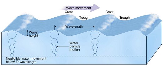
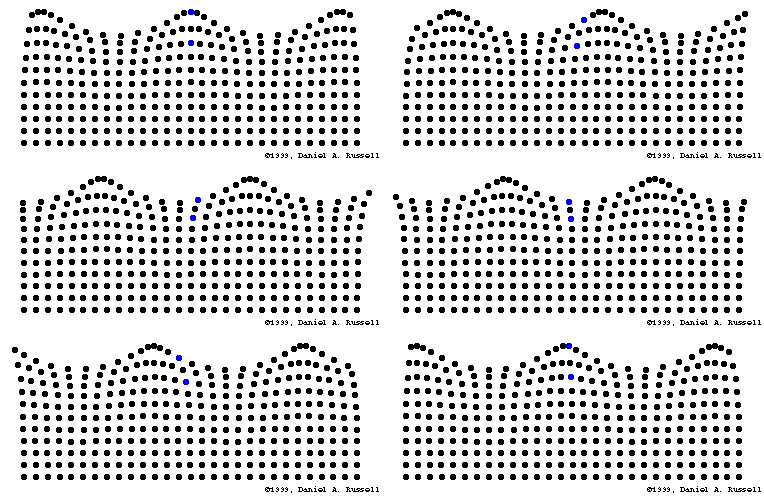
Ocean waves are a transmission of energy, not water.
Waves not only affect surface conditions, they also cause motion far below. As can be seen in the table of wave characteristics above, waves with a period of as little as seven seconds will affect the water column throughout the entire sport-diving range.
Close to the surface, the water motion is nearly circular. Close to the bottom, the vertical component is constrained, so that the motion is almost entirely horizontal. This is what is known as surge. Surge causes the lighter sediments to be picked up and mixed into the lower levels of the water column, which ruins visibility and diving conditions. Over time, this mixing may extend all the way up to the surface. Incidentally, fish and other marine life do not like this either, and usually disappear into holes and hiding places to wait it out, which makes diving under such conditions even more pointless.
Winds & Weather Patterns
All winds and weather are ultimately driven by heating from the sun. Winds are also affected by the Coriolis effect, which is due to the fact that the earth is a rotating sphere. Without going into a detailed explanation, suffice it to say that because of Coriolis forces, all air flows in the northern hemisphere will be deflected to the right. Weather is an incredibly complex topic that I am not even going to start to get into, nor would I be qualified, but the following stylized illustrations provide an admittedly oversimplified explanation of some common patterns.
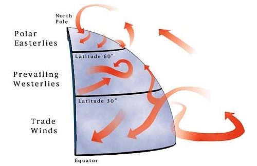
New Jersey lies in temperate latitudes between 30 and 60 degrees north, where the prevailing winds are from the west. Therefore, if nothing else is going on, you can expect generally westerly winds. But there is almost always something else going on, something called weather. Weather systems are classified by their barometric pressure. Standard sea-level barometric pressure is 29.92 inches of mercury. Low-pressure systems are less, high-pressure systems are more.
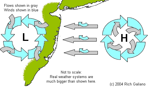
At the surface, air will flow into a low-pressure system "L", and out from a high-pressure system "H". These flows, represented as the curved gray arrows in the diagram above. are turned to the right by Coriolis forces, resulting in the circulating winds represented by the blue arrows. Therefore, in the northern hemisphere, high-pressure systems always circulate clockwise, and low-pressure systems always circulate counter-clockwise. Highs tend to have stronger winds than lows.
Atmospheric flows are essentially incompressible, so the air in such a system has to go to somewhere, or come from somewhere. Therefore, the resulting flow at the center of the system is vertical - a low is actually a column of rising air, while a high is actually a column of sinking air. Highs are typically associated with windy clear conditions and good weather, while lows are associated with storms and precipitation. A quick rule of thumb that derives from this is: With your back to the wind, the bad weather will be to your left. In the southern hemisphere, the circulation is opposite.
Naturally, air will flow from regions of high pressure to regions of low pressure. This flow is depicted as the straight gray arrows above, and since there are no exceptions to the Coriolis effect, this flow is also turned to the right, resulting in the winds shown by the small overlying blue arrows. These winds are in addition to the local prevailing circulation of the two systems and the local prevailing winds; the size of the arrows does not indicate the magnitude of the wind. Thus an offshore or "Bermuda" high will give us offshore winds, and more than likely large wind waves and/or swells. The overall resulting wind between the two systems in the diagram above would probably be from the southeast ( not shown. )
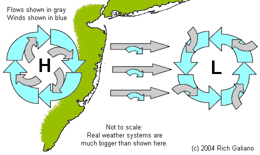
Reversing the situation, an offshore low is likely to cause westerly winds, which tend to "blow down" the waves coming in from the deep ocean. While one would hope for flat seas under such circumstances, remember that lows represent regions of stormy bad weather, which can in turn be churning out large swells. The overall resulting wind between the two systems in the diagram above would probably be from the northwest ( not shown. ) the location and movement of such high- and low-pressure systems is often affected by the jet stream and other happenings in the high upper atmosphere.
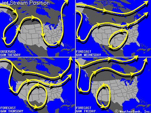
Weather systems are not stationary but move over time, generally with the prevailing winds from west to east in our region. As a weather system moves east through the area, the winds will shift. The leading edge of a low-pressure system will have southerly winds, which will shift around to the north as it passes. Nor'easters are actually the western edge of offshore storms, in which the wind will blow from the northeast.
Winds also undergo daily patterns, due to heating and cooling by the sun. Generally, surface winds will increase and veer to the right over the course of the day, and decrease and back to the left at night. Winds at the coastline show a different daily pattern, due to differential heating and cooling of the land and sea. During the day, the land heats up more than the ocean. The air above the land warms and expands, and rises up. Replacement air flows in from over the ocean, resulting in cool offshore breezes at the shore. At night, the situation reverses - the sea remains warm while the land cools significantly, resulting in on-shore winds which tend to quiet the sea. These very low-level and local winds are only slightly affected by Coriolis. Remember, all of these winds are set against the background of the prevailing westerlies.
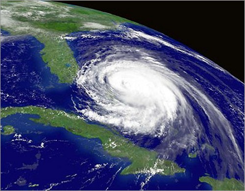
Hurricane Frances bears down on Florida in 2004,
with a clear counter-clockwise rotation.
What causes the bad weather in a low-pressure system? Recall that the air at the core of a low-pressure system is rising. Air cools as it rises, and if it contains significant moisture in the form of water vapor, it will eventually cool to the point ( the dew point ) where that moisture will condense out and fall to the ground as rain or snow. Conversely, the sinking air in a high-pressure system is warming and becoming drier. Again, this is an oversimplification, but still instructive.
A hurricane, like Frances above, is actually sucking moisture off the warm sea surface, carrying it up to altitude, and releasing it as rain. The heat released when the water vapor condenses causes further uplifting, resulting in the typical violent swirling winds, which draw in yet more water vapor. Thus the storm becomes self-sustaining, fueled by the moisture and heat contained in the sea. Deprived of this, such storms weaken and eventually fizzle out over the land. The cloudless 'eye' that many hurricanes develop is a small region in the center where the air is descending, rather than rising as it is in the rest of the storm. A major hurricane can throw swells out across the sea for over a thousand miles.
Temperature Effects
Atmospheric pressure is not the only factor that affects the weather - it is no surprise that temperature is also important. The boundaries between air masses of different temperatures are called fronts, and each of the four types of front has a particular weather pattern associated with it. Fronts are closely associated with pressure systems. A moving low-pressure system will commonly have a warm front at its leading edge and a cold front at its trailing edge, while a high-pressure system will often have a cold front at its leading edge and a warm front at its trailing edge. Any type of front is likely to signal precipitation.
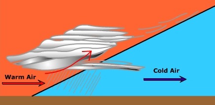
In a warm front, a mass of warm air overtakes a mass of cold air. The warm air gradually rides up over the denser cold air, cooling slowly and producing overcast conditions, flat layered clouds with light winds, and steady precipitation on the cold side of the front. A warm front is typically 100-200 miles deep, although thin high clouds may precede it by as much as 600 miles. A warm front is usually followed by a low-pressure system, with the attendant poor weather.
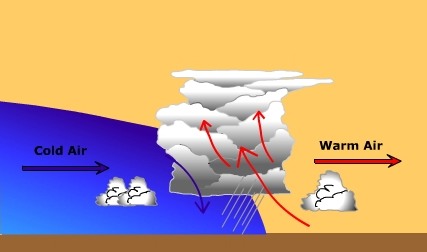
In a cold front, a mass of cold air overtakes a mass of warm air. The dense cold air wedges under the warm air, rapidly pushing it up and cooling it. This results in tall fluffy cumulus clouds, showery precipitation, gusty winds, and thunderstorms. A cold front is typically 30-50 miles deep, and much faster-moving than a warm front. Although the front itself is stormy, the weather behind it is usually clear.
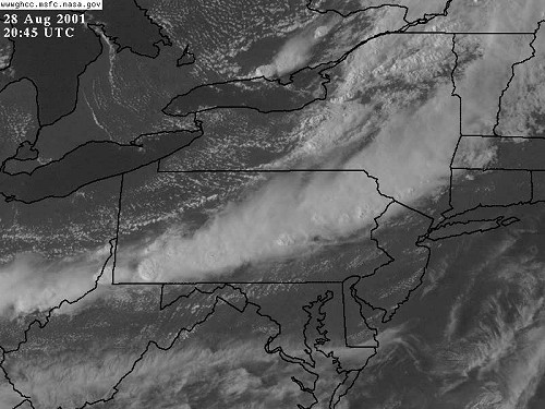
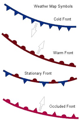
The other two types of front are occluded and stationary. A stationary front is like a non-moving warm front, with similar but weaker conditions. An occluded front occurs when a cold front overtakes a warm or cool front, resulting in two cold air masses at the surface with warm air above, and conditions similar to a weak cold front. This often occurs at the end of a storm, as the cold front at the trailing edge of a low-pressure system finally overtakes the slower-moving warm front at the leading edge. There is always a change in wind direction across a front, such that the wind will veer 10-20 degrees to the right as the front passes over. Fronts are indicated on weather maps as shown at right.
So what is the best weather for diving? The best weather is really no weather at all - no extreme highs, no extreme lows, and no extreme temperatures. In other words, nothing that will drive the winds that cause the waves. This is all stuff you learn if you want to be a pilot or a boat captain. You now know as much about the weather as the talking heads on TV. ( I hope that's not true! )
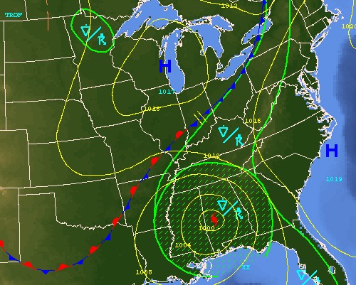
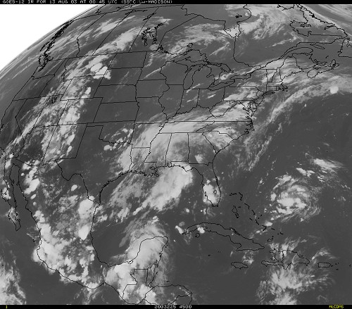
This chart shows the interaction between two weather systems: a High moving down from Canada and centered over the Great Lakes, and a Low centered over Alabama. The High is preceded by a cold front in the northeast, which has stalled against the Low in the south.
Normally, a High, with its cool dense air, would just bully a Low out of the way, but in this case, the Low is Hurricane Ivan, so all bets are off. If the cold front continues to the southeast, it may bottle up the hurricane in the south, with help from the High off the Carolinas. This is in fact what happened, although what would be much more likely is that the hurricane would slide along the cold front to the northeast, extending the stationary front as it goes.
This is exactly the mechanism by which most hurricanes move up the eastern seaboard. In this case, since the hurricane is moving over land, it will largely play itself out by the time it reaches our area. A hurricane that follows a more coastal or offshore route will maintain much more of its intensity as it travels, although it will weaken somewhat on reaching cooler water in the North Atlantic.
