Wire Drag

Wire dragging is an operation used to locate and/or reduce the navigational hazard of a sunken wreck, rock, or other obstruction.
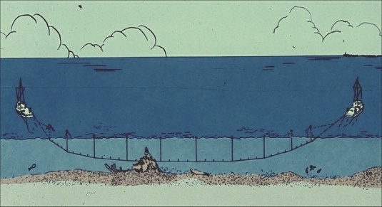
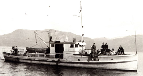
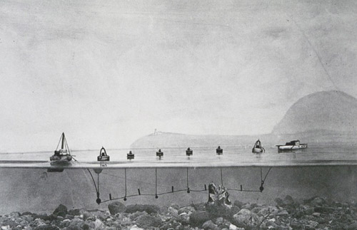
The operation itself is simple. A heavy steel cable or chain is attached to two tugboats and towed between them at a preset depth. If it snags, then the obstruction is located. The tugs can then pull the cable through the wreck, destroying it down to that depth. If the cable runs freely across an area, then it is known that that area is free of obstructions to that depth. Most of the larger wrecks in the area have been destructively wire dragged at least once.
The wire drag operation has been made largely obsolete by modern underwater survey methods, especially side-scan sonar.
Reminiscences of Wire Drag Work

N. H. Heck, U. S. Coast and Geodetic Survey
( From the U.S. Coast and Geodetic Survey
ASSOCIATION OF FIELD ENGINEERS BULLETIN, No. 3, June 1931 )
At present, there is not much wire drag work being done as some years ago, partly because the more important work is finished and partly because of lack of funds to undertake the remaining work.
There are still large areas where the use of the method is indispensable for the safety of navigation. Other methods will probably develop the existence of most shoals, but some may be missed and more likely the least depth, which is the thing the mariner cares most about, will be missed.
I have seen a rocky pinnacle charted as an 11-fathom shoal become, after four successive groundings of the drag, each time set so as to pass over the least depth previously found, an 11-foot shoal. Each time a more careful sounding than customary in the most careful hydrography when the drag is not used was made with the additional advantage of having the drag buoys as a guide, and yet the sharp pinnacles were missed. I have been on a coral reef in Porto Rico (sic), with general depths of about two fathoms and perfectly clear view of the bottom, and swung a leadline at 11 feet within 6 inches of a 5-foot coral projection without touching it.
In view of these considerations, some reminiscences about past occurrences during the period when I was on this work may be of interest.
Back in 1904 when the work started, a number of vessels of the Navy, using Penobscot Bay for maneuvering, had struck bottom, and striking the granite rocks of Maine leaves a very definite impression. A number of yachts en route for Bar Harbor struck bottom in an important channel. The first attempt to meet the situation was with the pipe drag, by which method a 36-foot pipe was carried below the vessel, which proceeded at a moderate speed. Some important findings were made, but the method was clumsy and expensive on account of the overhead of the vessel and the frequent need for repairs to apparatus. I spent one season under Captain Faris on this work on the Explorer. The same objection of too great overhead applied to the first season of wire drag in Frenchmans Bay when launches of the Bache and the Blake were used with the vessels standing by much of the time. Several years later the first wire drag work by a wire drag party, independent of vessels, was started in Eggemoggin Reach, Maine, under my direction. Our first effort was to prove the deep water clear and all known shoals were carefully avoided. As a result, we made fast progress and startled the office by telegraphic request for another smooth sheet before the season was half over. Curiously enough six years later we went over this same region examining the shoals and finding a considerable number of important dangers.

The development of the wire drag was a long story, with many persons taking part, but in those days few of our personnel realized the scientific possibilities which have since been developed in our hydrographic work. It was a matter of search for materials, inventions, and application of new methods just as is going on today in the acoustic work. For example, we first used telephone wire, which did very well, but invariably broke when we struck bottom. We found a wire developed first by Krupps in Germany and later improved by Roebling which met all requirements.
Many interesting things happened in this work. For example, there was the project of the so-called Beehler Channel into Key West. Commodore Beehler was Commandant at the Naval Station at Key West and he conceived the idea that a straight channel might replace the existing main ship channel. I received instructions to test out this possibility. The difficulty at Key West is to pass the inner reef, a mass of mushroom-shaped coral heads and other formations extending 16 to 20 feet above an otherwise flat bottom and in many places as thick as the trees of a forest. The idea turned out to be quite impossible, but one day we thought we had found a channel. Approaching the reef with the intention of finding the obstructions on a given line, and using a 500-foot drag, it became very hazy and just as we came to the reef, we were unable to get a position. When we finally got a position we had passed through the reef. We tried to repeat the performance and found it quite impossible. We must have missed by inches at least six of the large coral heads. In the main channel, we found a pinnacle which might have changed history. It was directly in the channel and the Maine might easily have struck it when outward bound in her start for Havana. We caught the drag on this several times and the divers who placed the dynamite for the Army engineers to remove it found several large wire drag sinkers and various wires festooned around it. When coral heads are blown up the pulpy inner portion floats and looks very much like pumice.
One day we encountered a very strong current in a place where strong currents had never before been noted. There were no particular indications of bad weather, but that night a very heavy northerly arrived, showing that in the Keys lying between the Gulf of Mexico and the Straits of Florida barometric conditions may have powerful effects even before their existence is realized.
On one occasion in Maine, a sub-party under Mr. Swick (now mathematician in the Division of Geodesy) was searching for a reported shoal off Penobscot Bay directly in the path of battleships going to the Rockland trial course. He had to give up work because of the large number of lobster pots and had to make the search later. However, since the area had not yet been reached in the regular survey, Mr. Swick decided to run a line in the homeward bound direction to make it a full working day. He had just decided to call it a day when the signals were temporarily obscured and a fix was delayed. Just as they became clear, the drag went aground. A 22-foot rock, not even known locally to exist, was found, and of course, charted, but not buoyed. Some years later the battleship Arkansas, not yet accepted but en route to the trial course, was proceeding with a local pilot. The vessel struck this rock, and on examining the pilot's chart, it was found that his chart was old and did not show the rock. That he was a good pilot otherwise was proved by the fact that the rock plotted exactly on the course he had laid out on his chart. However, the answer was $80,000 worth of damage and considerable delay in the delivery of the vessel.

That the newspaperman can often see interest in what appears to be very routine to us was never better exemplified than by the performance of a writer of the Boston Transcript. He went out one day and, to my view, it was a day of very routine character, but he wrote up as interesting an account of an operation of the Coast and Geodetic Survey as has ever been written.
Perhaps the most striking thing that happened was the development of the wire sweep. After returning from England from special duty with the Admiralty on anti-submarine devices during the War, I spent several months at the New London Naval Experimental Station ( the forerunner of the present Naval Research Laboratory in Anacostia ) before returning to duty in the Coast and Geodetic Survey. During this period we were all trying to see what application could be made of the wartime devices. One day it occurred to me that, with modification, the mine sweep principle might be applied to wire drag work. I simply put the idea away for future reference. After some interesting duty in Lake Washington, Seattle, locating the trees of a forest which, perhaps a thousand years ago, sank beneath the lake in an almost vertical position and were an obstruction to navigation, I was assigned to command of the EXPLORER on wire drag and combined operations in Southeast Alaska. We found on hand a large amount of buoys, metal floats, and other materials hastily stored by Messrs. Colbert and Daniels when they discontinued work to enter the Navy. Much of this material was obviously in bad condition, but we selected a considerable amount which seemed to be all right. We started work with a drag 12,000 feet in length and the first day went all right. The second day just as we were about to start work the entire drag with most of our wire drag equipment except wire, of which we had an ample supply, sank beneath the surface in perhaps two minutes' time. All the buoys and floats were crushed. It looked bad for our season's work and Mr. Senior, Executive Officer, and Mr. G. C. Jones, who was in charge of the drag work, had gloomy faces. I saw only one thing to do - try out the sweep idea and use gasoline drums for buoys. We put rounded wooden bottoms on them to partially streamline them and later found means to pump air into them. This worked out so well that, while we ordered no more equipment, the season's output was the largest to date for Alaska and, in fact, the wire sweep work went so fast that it was hard to keep it from getting ahead of the control. This speeding up resulted in finishing the important work of sweeping the main channels of Southeastern Alaska by several years over estimated time.
Since the sweep wire was continuous to the vessel and without a rope section intervening as in the wire drag, an interesting fact was observed. When the sweep struck a rock, it did not catch immediately but slipped along while taking its grip. As a result, the wire acted like a banjo string, and actually a tune was played with varying notes which could be heard all over the vessel. This is probably the longest string instrument in existence since on one occasion the rock was 1-1/4 miles away.
The World War caused untold loss, but it is interesting to note that in the work that has been described and in the acoustic sounding and radio position finding, which are a direct outcome of war-time developments, we have added and are adding important amounts to the war salvage.

