Coastal Composition (1/2)

The boundary between land and sea is far from stable and static. Water levels rise and fall, and waves and currents move huge amounts of sediment, rearranging the coastline in ways that are often not compatible with the goals and constructions of man.
Coastal Erosion
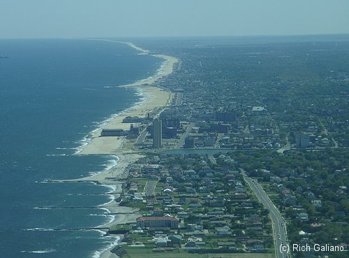
The New Jersey shore - looking south over Deal ( no beach ) Allenhurst ( narrow beach ) to Asbury Park and south ( wide beach. ) Development is right up to the edge of the beach, with no dunes or buffer zone.
It is a fact that ocean levels are rising: estimates vary between 15mm and 15cm per year. In addition, in New Jersey, many coastal areas are subsiding (lowering) at about 3 mm per year. Sea level rise is due to the melting of the polar ice caps, but what is causing this is not so clear. It seems probable that we are currently in the middle of a global warming trend. Whether we caused this ourselves or it is just part of a long-term natural cycle that we can hardly be aware of is open to debate. Subsidence of the land is likely due to the lowering of the underground aquifers by agricultural irrigation.
This problem is by no means unique, nor does New Jersey have the worst example. In Nigeria (west Africa), some shorelines are retreating 5 miles per year - or 72 feet per day! Water levels on the Great Lakes have also been increasing steadily in recent times, resulting in similar problems in that region. In many places where there is adequate sediment being added to the system, sea-level rise is not a problem. Along the Gulf Coast, beaches continue to accrete thanks to the discharge of the Mississippi River. However, most of New Jersey is not so lucky.
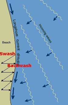
The New Jersey coastline is composed entirely of sand beaches. The location and shape of any soft, sandy, unconsolidated shoreline like this is determined by an equilibrium between erosion and deposition. The greatest force affecting this equilibrium is waves. Ocean waves are caused by the wind. Waves striking the shore will tend to redistribute the sediments there. If the waves strike at an angle, a current along the shore will develop. This will tend to transport suspended particles along the shoreline. Wind has a lesser effect, redistributing blown sand in the higher areas, where dunes act as reservoirs of sand during periods of erosion. Finer particles are more affected by wind than coarser ones.
At any location, these forces will tend to either remove or deposit material, often with a seasonal pattern. In New Jersey, large winter storm waves remove sand from the beaches to deeper waters, and smaller summer waves put it back. Sediments that are lost to waters beyond the reach of waves are replaced by new materials from the land, mainly in river flows.
The rising of the sea level changes this equilibrium. The generally accepted model for this change is depicted below. The point where Sea Level 1 meets Bottom Contour 1 determines the location of the beach. The lower limit of wave action is shown as the dotted line below each surface level. In this zone, waves will pick up and redistribute sediments from the shore. Larger waves reach deeper, but below some limiting depth wave action becomes negligible, and any sediment transported there will simply settle out of the system. Thus, in coastal areas there will tend to be a characteristic equilibrium depth, determined by the magnitude of wave action.
Beach Erosion due to Sea Level Rise: Bruun's theory
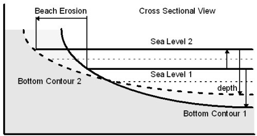
The depth to which wave action is a factor in sediment transport is shown by the thin dashed line below the surface line. As the sea level rises gradually from 1 to 2, sediments are shifted from the beach and shallow inshore areas to deeper waters offshore, where they settle permanently below the wave zone. Areas between the two bottom contours show loss of sediment on the left, and accumulation on the right. The offshore depth thus remains constant, and the beach erodes.
When the sea level rises ( not all at once, like the diagram, but gradually ) the loss of beach is not simply due to the water creeping up the slope. When the sea level rises, the offshore depth also increases. This makes room for more sediments offshore, below the wave zone. The result of this is that a proportionately greater amount of the sediment that is stirred up by the waves on the beach is deposited offshore. Thus the normal coastal processes result in a redistribution of sand from the beach to the seafloor. so that the beach is carved away while the equilibrium depth is maintained. There is actually an entire mathematical model which attempts to predict rates and amounts of loss, with generally little accuracy, but it is accepted in principle anyway.
Under natural conditions, one of two things will happen in these circumstances. Either new sediment brought into the system will make up the losses, or the entire beach system will slowly shift inland, converting the area from woodlands ( or whatever ) to dunes to beach to sea in a smooth process. The process for barrier islands is different - when they get low enough and thin enough, constant overtopping by waves will wash them into the mainland.
Most new sediment is brought into the coastal system by rivers. The major rivers affecting the New Jersey coast are the Hudson and the Delaware, and to a lesser extent the Raritan, but the amount of sediment from these sources is inadequate to maintain the present coastline, so it erodes.
Coastal Protection
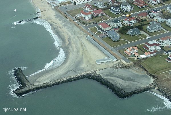
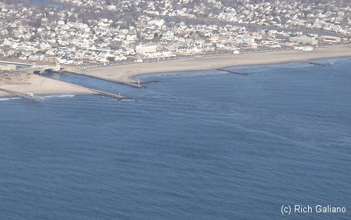
Allenhurst Jetty - Note the complete absence of beach in Deal on the right - the only town which did not take part in beach replenishment. Longshore drift is left to right here.
Most of the coastline of New Jersey has been developed at least to some extent, often on barrier islands. Atlantic City is one of the foremost examples of beachfront development in the world, a major city built entirely on a barrier island. Allowing the ocean to come in and reclaim these areas is simply not an option, the loss of billions of dollars in property and an entire economy would result. Even in less extreme examples, most of the backing dune areas have been built over, and development goes right up to the water. Thus we have drawn an immovable line in the sand.
In the past, the response to coastal erosion was to armor the shoreline where it was economically justifiable. These are the so-called "hard methods", and were first employed in New Jersey in the 1870s, initially near Sandy Hook / Sea Bright. These are depicted below. These structures are generally built of rock and concrete, sometimes of heavy timbers.
Hard Shoreline Protection Structures
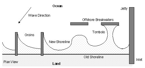
The hypothetical old shoreline is denoted by the straight heavy line. Various man-made structures are shown schematically in gray, along with their effect on the shoreline - the thin curved line. Groins are structures built out from the shoreline to trap sand in the longshore drift. Breakwaters are built offshore, parallel to the coast. The purpose of a breakwater is to lessen the impact of waves on the shore, much like a natural reef, and it need not protrude from the water to do so. A tombolo is a sand spit that forms between the beach and a breakwater. A groin and a breakwater are sometimes combined into a T-shaped structure. A jetty is much larger than a groin, and is built to stabilize an inlet or other coastal feature rather than to capture sand.
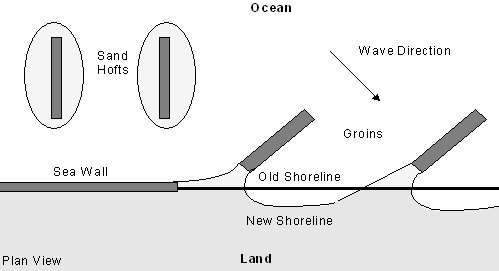
A sand hoft is an offshore island created by the accumulation of sand around an old jetty that is no longer attached to the land due to shoreline retreat. These can have a stabilizing effect on the beach in much the same way as breakwaters and natural barrier islands. A seawall is an onshore construction used when erosion is so great that there is no beach left. Seawalls are large heavy structures that face the sea, while bulkheads are lighter structures built in protected areas. Finally, groins need not be built perpendicular to the shore to be effective.
The most obvious method of shoreline protection is to simply build a wall against the sea. This is a difficult and expensive undertaking and is often a last-ditch solution. The main problem with this is that the sea will continue to erode the area in front of the wall until there is nothing left. If the foundations of the wall are not deep enough, then in time sea will erode away beneath the base of the wall, and it will collapse. If the wall is not tall enough, it will be overtopped by storms, and destruction will result. In any case, the constant beating of waves requires maintenance throughout the life of the structure. Light duty seawalls, or bulkheads, are used in harbors and protected areas, where their function is more to keep the land from sliding into the water than to stop active erosion.
A less obvious method of coastal protection is to build a wall in the sea. This is called a breakwater. Its purpose is to break the force of incoming waves before they strike the beach. It may or may not protrude from the water. In either case, it is a navigation hazard. Breakwaters must be tall enough that a storm surge will not reduce their effectiveness. If it is too short, it can actually have a negative effect - allowing large destructive waves in, but blocking smaller beneficial ones. The figure above shows a typical configuration of short breakwaters and gaps, along with the resulting beach shapes that develop behind them. Breakwaters are common around the Pacific ( California, Japan ), probably because the waves are so large. I don't think there are any breakwaters in New Jersey.
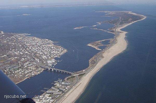
Interestingly, government and insurance company predictions of storm damage for areas like Sea Bright are all based on the wall holding, they don't even want to think about what would happen otherwise. Apparently, Sandy Hook connected to the mainland in the 1830s, prior to which the Navesink river discharged straight out into the ocean, as did the Shrewsbury. The river cut through again, but the connection was rebuilt in the 1850s for a railroad. This washed out in the 1890s and was "permanently" closed in 1901.
A variation on the breakwater is the floating breakwater. This is a flexible structure that is anchored offshore and serves to dissipate wave energy before it strikes the shore. The kelp beds in California are natural breakwaters. Attempts to construct similar breakwaters of artificial seaweed have been made, some even here in New Jersey. These have all failed, in part because the plastic seaweed gets weighted down by the real kind and sinks. Another type of floating breakwater is constructed of old car tires tied together with steel cables. These are effective, but not suitable for high energy areas.
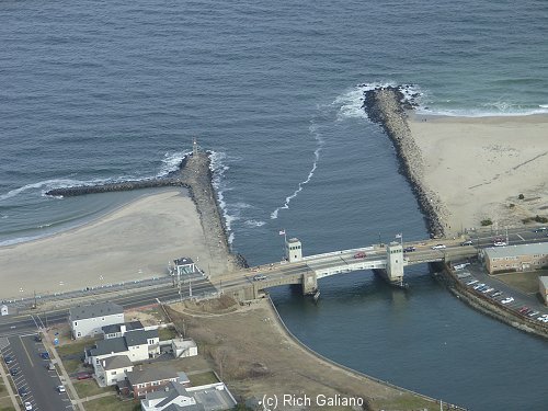
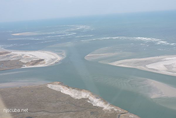
The final hard method of shoreline protection is to construct a wall into the sea. These are known variously as jetties or groins, depending on their purpose. A jetty is a structure built perpendicular to the shore at an inlet or river mouth. Its purpose is to prevent the channel from either closing or shifting is position. This sort of behavior is unacceptable in developed areas, with bridges and harbors and other man made structures in place. Most of the open inlets in the state are maintained in this manner, including both the Shark River and Manasquan River. Egg Harbor inlet is not stabilized and shifts continuously. The Metedeconk River once emptied into the sea but closed naturally in 1755. The mouth of Cheesequake Creek in Laurence Harbor is also stabilized by jetties.
A groin is similar in construction to a jetty but serves a different purpose. Its purpose is to trap sand from the longshore drift and retain it locally. Groins are usually built in series, or "groin fields", and these or other hard structures extend over almost half of the ocean coast of New Jersey. For a groin to be effective, there must still be some sand present. In trapping sand from the longshore drift, a groin or jetty will cause sand starvation downstream of itself. Thus, although local erosion is reduced, erosion elsewhere is increased.
In New Jersey, towns along the shore have historically built groins which basically steal sand from the next town down-drift, which is then forced to build its own groins or lose its beach. Thus, groins have propagated along almost the entire coast, until eventually a sort of equilibrium was achieved which resulted in a saw-tooth coastline rather than a straight one, with beaches that are on average no wider than they would be with no groins. Today it is recognized that groins are ineffective for long-term coastal protection.
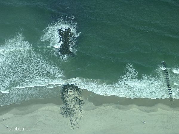
If the beach is allowed to erode around and behind the groin, it will become a detached sand hoft. This process was well into development in many areas on the New Jersey shore before steps were taken to repair the beaches. However, even in this state, some sand will be retained, and there is still a stabilizing effect on the beach behind, like a small barrier island. Groins are not always built perpendicular to the shore. Sometimes they are built perpendicular to the direction of the incoming waves. Groins and jetties are sometimes capped with a breakwater, as is the case at Belmar ( north jetty. ) All of these structures have a design life of about 50 years, with periodic maintenance.
Environmental Impacts of Hard Structures
Seawalls are generally only constructed in highly developed areas that have already been affected greatly by prior construction and erosion. The change to the local ecosystem is usually minor, since it is generally highly disturbed to begin with. Most of the construction can be done from the landward side, further minimizing environmental impacts.
Groin construction involves trucking heavy materials across the dunes and beach. To avoid disturbing colonial nesting birds, construction should take place during fall and winter. Burial of sandy substrate is of minor significance, since the area of the groin is small compared to the entire beach. Redistribution of sand around the groin occurs at a slow enough rate that most organisms are able to cope with it. Once it is constructed, a groin or jetty provides a hard substrate to which many fish and invertebrates are attracted.
Beach Replenishment
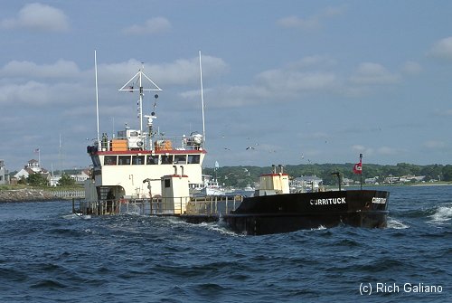
While the methods outlined above have been of use in the past, modern technology has made better methods possible. These are the so-called soft methods: beach nourishment or beach replenishment, which consists of replacing lost sand with material taken from elsewhere. The first example of such a method being successfully used was in 1920, at Santa Barbara California. These methods require a great deal of energy to move enormous amounts of sand. A single such project in Atlantic City was likened to placing 175 football fields piled 25 feet high, or about 20 supertankers of sand, and until relatively recently this was simply not possible.
Beach Restoration by Offshore Berm and Artificial Fill
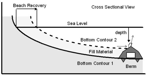
An offshore berm is built below the surface of the water from coarse materials. Sediment accumulates on the shoreward side of the berm, either by natural or artificial means, resulting in a new bottom contour. The berm shown here is constructed from concrete and is in use in several places off the coast in New Jersey. The flume at the top redirects back-flowing water upwards to retard waves during a storm.
The figure above shows one possible scenario for beach replenishment. First, an offshore berm or reef is constructed from some materials resistant to wave action. In some areas, sand will accumulate naturally inside the berm, replenishing the beach, while in others sand must be brought in by artificial means. Sometimes this is done without the use of a retaining structure. In any case, materials artificially brought in will in time be removed by natural processes. Most such endeavors have a design life of about one to five years. This is what is being done along much of the north New Jersey shoreline.
The major problems of this method are finding suitable fill material, and transporting it. The fill material must be of the same or larger grain size as the original material, or it will be swept away. Almost any offshore source will contain some of the correct grain size, but some sites are better than others. This leads to the idea of fill factor, which is a number, always greater than one, which represents the ratio of sediment placed to the actual increase in sediment measured after some time interval. The renourishment factor takes into account the natural rate of erosion at the site to estimate maintenance requirements.
This sort of beach replenishment works well with existing groins, where it is known as "filling the groins." Sometimes existing groins are notched or removed entirely to allow the natural processes to distribute the sand once more. An interesting variation of this is used on the North Sea beaches in Germany. A jetty is built out from the shoreline entirely from sand. It is then allowed to erode onto the beaches downstream, both replenishing and protecting them. When the jetty is worn down, it is rebuilt.
The location of the sand source is a major consideration. Taking fill from sources on land is generally an environmental nightmare, especially in New Jersey. Taking it from offshore too close to the beach increases the offshore depth thereby increasing the rate of erosion, and can be self-defeating. Another consideration is pollution, as many harbor sediments are far too polluted to place on a beach. High transportation costs are another factor. Up to 3/4 of all dredgings from navigational projects are unsuitable as beach fill for these reasons.
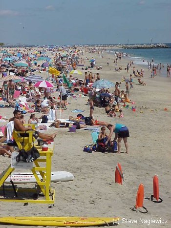
It has been suggested that if one wished to make the long-term expenditure, beaches could be maintained or increased by this method indefinitely, even with rising ocean levels. The economic analysis is not complicated: doubling the width of the beach doubles the number of people ( tourists ) that can use it. Twice as many people will pump twice as much money into the local economy, not just beach badges, but hotels, restaurants, gas stations, etc, increasing tax revenues and easily making up the cost of pumping sand to maintain the beach.
Overall trends in waterfront management nowadays are away from use of hard structures and toward use of soft structures, which are both cheaper and more aesthetically pleasing. Four states, New Jersey, Maine, North Carolina, and South Carolina, have already taken steps toward banning any new construction of hard structures. Another trend is toward abandonment of threatened areas, although as mentioned earlier, not all areas may be abandoned ( such as Atlantic City. ) Changing laws to prevent construction in beachfront and dune areas, as well as changes in the government insurance policies all contribute to more intelligent management, i.e., allowing natural processes to take place.
Environmental Impacts of Beach Replenishment
The state plan on shoreline protection states that beach nourishment programs have the most significant impact on the natural environment of the various methods available, but this is of minor concern due to the short-term duration and highly localized impact. Offshore dredging likewise has little significant adverse impacts as long as productive shellfish beds are avoided. During both operations, the short-term local impacts include increases in turbidity, habitat disturbance, and air and water quality degradation.
The periodic placement of large quantities of sand on the beach would bury the organisms of the upper, middle, and lower beach zones. The larger and more active of these would be able to escape the impact of burial, either by fleeing, or by digging themselves out. Surf clams have been shown to be able to dig their way out from under up to two feet of sand. Smaller less active species would no doubt be killed, but colonization by planktonic larvae from adjacent unaffected areas is rapid, and the long-term effect is small.
After placement, finer particles are washed out of the sand and form a plume down-drift of the site. This is not thought to affect organisms inhabiting the surf and near-shore areas, as they must be able to cope with similar conditions during storms, etc ( runoff from the land. ) If the sediments are polluted, that's a different story, but most of the desirable, coarser grained sediments that are dredged offshore are not contaminated.
Dredging operations have short-term negative impacts on the benthic community - essentially everything is killed. Recolonization is expected to begin within two weeks, although it could take up to a year. The most important thing seems to be careful selection of the dredge site, away from shellfish beds, reefs, and other concentrations of life.
This does not all just seem to be the government whitewashing what they planned to do anyway. The few sources on the subject all say that the long-term biotic impacts of beach nourishment are negligible. Some projects have been monitored for over thirty years. Original fauna is destroyed, but new fauna develops in its place. Surprisingly, although one would expect changes in the species composition after such a disturbance, such as a large increase in the numbers of opportunistic species, this usually does not occur. Other studies indicate that mobile species flee the disturbance, while infaunal organisms are killed, but within a year are replaced by more of the same from other areas.
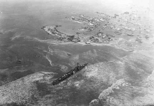
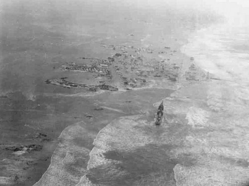
Actually, this is not all so surprising. If these creatures can survive a hurricane destroying their habitat for perhaps hundreds of miles, they should take our puny efforts in stride. Below are images of Long Beach Island after the March storm of 1962. The island is practically gone.
-- based on a paper I wrote in college

