SW Mohawk "Coffee"

- Type:
- shipwreck, sailing ship
- Depth:
- 75 ft
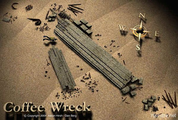
The "Southwest Mohawk" or "Coffee Wreck" is nothing like its namesake. Artifacts found on the wreck indicated that it was a late eighteenth-century sailing ship and not a barge.
An assembly of fairly large timbers forms a low solid deck over most of the wreck, with bundles of iron pipes and stone ballast blocks scattered around. The bottom is clean, white, almost Caribbean sand. Visibility tends to be relatively good, and it is very easy to follow around the edges of the wreck or explore over the top without getting lost. Caverns and gaps around the edges of the wreckage provide homes for swarms of Sea Bass, some of them huge, and a few Tautogs.
Captain John Bogan recounts the naming of the wreck:
My dad ran the Shamrock out of Broadway (Point Pleasant), where the Dauntless is today. My brother Bob was first and sometimes second mate. He used to drive my father crazy when he'd ask, "What spot is this, what spot are we going to?" Dad had been fishing the Mohawk and was heading towards Hankins. A commercial fisherman/friend held up 2 giant blackfish when he was going by. Dad slowed, and just off the buoys drifted over and found the wreck. My brother, as usual, was giving him the third degree. So dad said, "This is the Coffee Ground spot."
Drawing courtesy of Aaron Hirsh


Questions or Inquiries?
Just want to say Hello? Sign the .