Visibility
I have found no correlation between good visibility and anything else at all. Calm seas certainly don't hurt, but the worst visibility I have ever been in was with a 1-foot surf on the beach. There is however a very good correlation between bad visibility and storms, which is why a single hurricane can end the season.
Other factors which influence visibility are: algae blooms, spawning seasons of some invertebrates, which can fill the water with tiny swimmers, jellyfish ( yes, so many you can't see through them, luckily they don't sting, ) other divers churning up the bottom, and just plain gunk in the water. I don't know how to predict most of these, except to say that if you dive a lot, sooner or later you will see some good visibility. Sometimes in the ocean, the visibility will be different in different depth layers. I have seen the viz go from 3 ft on the way down the anchor line to 20 ft on the wreck.
Visibility does tend to get better and more reliable the further out you go from the shore, but that's not a rule either. There is also a tendency for improved visibility as you go south ( and east, for Long Islanders ) away from the turbid outflow of the Hudson River. With rare exceptions, pollution is one thing that is not a problem.
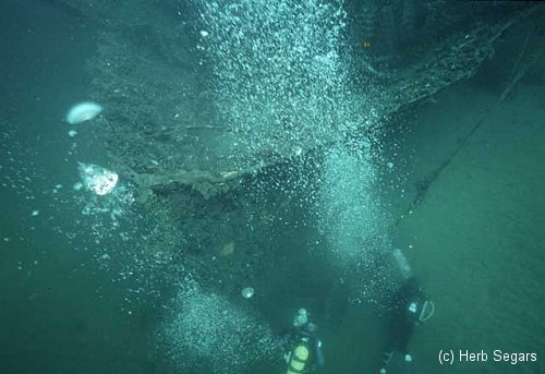
By the way, just what is the definition of good visibility in New Jersey waters? I'd say 6-8 ft in the inlets, and anything over 12 ft at sea. That's what makes me happy, but I have willingly dived in less, a lot less. The best I have seen yet was about 40-50 feet, not even far offshore.
Note: If you are claustrophobic, or uncomfortable with the idea of sharing your pool with about a zillion tiny wigglers that you don't even know a name for, then you should think twice before diving these waters.